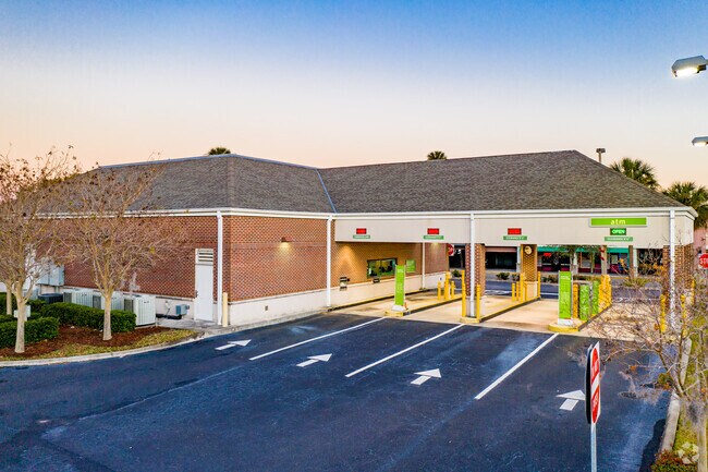
Property Record
11883 Indian Rocks Rd, Largo, FL 33774


NEARBY LISTINGS FOR SALE OR LEASE
Property Detail
11883 Indian Rocks Rd
Tampa-St. Petersburg-Clearwater, FL
Beg 228.35Ft N & 47.31Ft E
07-30-15-00000-440-1300
BEG 228.35FT N & 47.31FT E OF SW COR OF SE 1/4 OF SE 1/4 RUN N 128.02FT TH W 14.17FT TH N 26.23FT TH E 227FT TH S 128.3FT TH E 10.15FT TH S 25.41FT TH W 223.06FT TO POB
Financialbuilding
Pinellas
X
Florida
12103C0114H
1300
2024
0.77 AC
2025
Mid-Pinellas
025209
Tampa/St Petersburg
5,402 SF
DEMOGRAPHICS near 11883 Indian Rocks Rd
1 Mile
3 Mile
5 Mile
2024 Total Population
11,959
72,311
161,631
2029 Population
12,152
72,975
163,540
Pop Growth 2024-2029
+ 1.61%
+ 0.92%
+ 1.18%
Average Age
50
48
49
2024 Total Households
5,834
32,956
76,023
HH Growth 2024-2029
+ 1.59%
+ 1.04%
+ 1.23%
Median Household Inc
$65,030
$72,734
$65,620
Avg Household Size
2.00
2.10
2.10
2024 Avg HH Vehicles
2.00
2.00
2.00
Median Home Value
$327,523
$343,636
$314,765
Median Year Built
1975
1975
1975
Nearby Places
Map Layers
Map Styles
 Street
 Aerial
- Restaurants
- Banks
- Shops
- Fitness
- Groceries
PUBLIC TRANSPORTATION
AIRPORT
St Pete-Clearwater International
DRIVE
WALK
Distance
St Pete-Clearwater International
27 min
12.3 mi
Tampa International
DRIVE
WALK
Distance
Tampa International
40 min
23.0 mi
Nearby Properties
Address
Land Use
TOTAL SIZE
Lot Size
Zoning
Address
Land Use
TOTAL SIZE
Lot Size
Zoning
537,958 SF
41.61 AC
C2
Address
Land Use
TOTAL SIZE
Lot Size
Zoning
367,081 SF
13.80 AC
Address
Land Use
TOTAL SIZE
Lot Size
Zoning
223,748 SF
100.32 AC
R3
Address
Land Use
TOTAL SIZE
Lot Size
Zoning
333,425 SF
33.66 AC
Address
Land Use
TOTAL SIZE
Lot Size
Zoning
318,185 SF
38.78 AC
C2
Address
Land Use
TOTAL SIZE
Lot Size
Zoning
509,129 SF
18.74 AC
Address
Land Use
TOTAL SIZE
Lot Size
Zoning
545,062 SF
8.37 AC
Address
Land Use
TOTAL SIZE
Lot Size
Zoning
294,101 SF
22.55 AC
Address
Land Use
TOTAL SIZE
Lot Size
Zoning
129,600 SF
7.09 AC
Address
Land Use
TOTAL SIZE
Lot Size
Zoning
267,730 SF
35.84 AC
AE
Address
Land Use
TOTAL SIZE
Lot Size
Zoning
6,098 SF
374.66 AC
AE
Address
Land Use
TOTAL SIZE
Lot Size
Zoning
157,904 SF
0.57 AC
Address
Land Use
TOTAL SIZE
Lot Size
Zoning
186,391 SF
11.86 AC
Address
Land Use
TOTAL SIZE
Lot Size
Zoning
157,769 SF
4.47 AC
Address
Land Use
TOTAL SIZE
Lot Size
Zoning
152,088 SF
92.28 AC
PC
Address
Land Use
TOTAL SIZE
Lot Size
Zoning
133,440 SF
6.85 AC
RM15
Address
Land Use
TOTAL SIZE
Lot Size
Zoning
102,073 SF
9.07 AC
Address
Land Use
TOTAL SIZE
Lot Size
Zoning
160,134 SF
18.61 AC
R2
Address
Land Use
TOTAL SIZE
Lot Size
Zoning
95,997 SF
13.61 AC
RM15
Address
Land Use
TOTAL SIZE
Lot Size
Zoning
167,424 SF
17.30 AC
RM1
Address
Land Use
TOTAL SIZE
Lot Size
Zoning
110,192 SF
4.58 AC
Address
Land Use
TOTAL SIZE
Lot Size
Zoning
36,102 SF
2.32 AC
Address
Land Use
TOTAL SIZE
Lot Size
Zoning
120,041 SF
9.66 AC
Address
Land Use
TOTAL SIZE
Lot Size
Zoning
90,234 SF
9.82 AC
R2
Address
Land Use
TOTAL SIZE
Lot Size
Zoning
213,218 SF
15.26 AC
Address
Land Use
TOTAL SIZE
Lot Size
Zoning
80,296 SF
19.86 AC
R2
Address
Land Use
TOTAL SIZE
Lot Size
Zoning
65,069 SF
7.64 AC
R3
Address
Land Use
TOTAL SIZE
Lot Size
Zoning
Address
Land Use
TOTAL SIZE
Lot Size
Zoning
56,655 SF
5.98 AC
R3
Address
Land Use
TOTAL SIZE
Lot Size
Zoning
9.55 AC
The World's #1 Commercial Real Estate Marketplace
Connect with us
© 2026 CoStar Group
The information above has been obtained from sources believed reliable. While we do not doubt its accuracy we have not verified it and make no guarantee, warranty or representation about it. It is your responsibility to independently confirm its accuracy and completeness. Any projections, opinions, assumptions, or estimates used are for example only and do not represent the current or future performance of the property. The value of this transaction to you depends on tax and other factors which should be evaluated by your tax, financial, and legal advisors. You and your advisors should conduct a careful, independent investigation of the property to determine to your satisfaction the suitability of the property for your needs.