Property Record
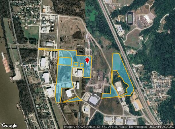
1189 Twp Rd, South Point, OH 45680

NEARBY LISTINGS FOR SALE OR LEASE
Property Detail
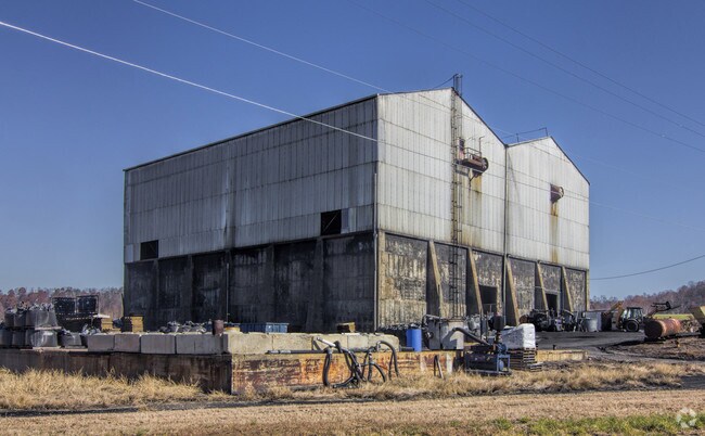
1189 Twp Rd
39-001-0300-000
L Sd
Warehouse
17-2-31/32 L SD L LESS 55.86, 4.00,10.10, 5, 6.04,6.50, 4.90, 6.80, 5.77, .57, 2.23, 5.00, 3.31, 1.13, 4.34 , 5.61 BAL 49.05AC
A
Lawrence
54099C0015D
Ohio
2024
49.05 AC
2025
Lawrence County
051100
Huntington/Ashland
19,988 SF
Huntington-Ashland, WV-KY-OH
DEMOGRAPHICS near 1189 Twp Rd
1 mile
3 mile
5 mile
2024 Total Population
2,421
19,747
46,829
2029 Population
2,341
19,332
45,924
Pop Growth 2024-2029
(3.30%)
(2.10%)
(1.93%)
Average Age
41
41
42
2024 Total Households
1,009
8,253
19,704
HH Growth 2024-2029
(3.17%)
(1.99%)
(1.84%)
Median Household Inc
$41,513
$45,207
$47,741
Avg Household Size
2.40
2.30
2.30
2024 Avg HH Vehicles
2.00
2.00
2.00
Median Home Value
$113,636
$115,892
$121,011
Median Year Built
1975
1968
1966
Nearby Places
Map Layers
Map Styles
 Street
 Aerial
Transit
 Traffic
 Biking
Places
Listings with unknown addresses are not visible on the map
- Restaurants
- Banks
- Shops
- Fitness
- Groceries
PUBLIC TRANSPORTATION
COMMUTER RAIL
Ashland Amtrak Station (Cardinal - Amtrak)
Drive
Walk
Distance
Ashland Amtrak Station (Cardinal - Amtrak)
12 min
6.4 mi
AIRPORT
Tri-State/Milton J Ferguson Field
Drive
Walk
Distance
Tri-State/Milton J Ferguson Field
28 min
17.2 mi
Freight Ports
Port of Toledo
Drive
Walk
Distance
Port of Toledo
342 min
262.3 mi
Nearby Properties
Address
Land Use
TOTAL SIZE
Lot Size
Zoning
Address
Land Use
TOTAL SIZE
Lot Size
Zoning
116,640 SF
0.97 AC
COMMERCIAL
Address
Land Use
TOTAL SIZE
Lot Size
Zoning
123,920 SF
6.81 AC
Address
Land Use
TOTAL SIZE
Lot Size
Zoning
2.83 AC
Address
Land Use
TOTAL SIZE
Lot Size
Zoning
0.10 AC
OTHER
Address
Land Use
TOTAL SIZE
Lot Size
Zoning
141 AC
COMMERCIAL
Address
Land Use
TOTAL SIZE
Lot Size
Zoning
47,107 SF
4.67 AC
Address
Land Use
TOTAL SIZE
Lot Size
Zoning
8,364 SF
3 AC
Z02
Address
Land Use
TOTAL SIZE
Lot Size
Zoning
1.46 AC
COMMERCIAL
Address
Land Use
TOTAL SIZE
Lot Size
Zoning
1,920 SF
33.30 AC
Z03
Address
Land Use
TOTAL SIZE
Lot Size
Zoning
126,716 SF
10.60 AC
Address
Land Use
TOTAL SIZE
Lot Size
Zoning
54.65 AC
Address
Land Use
TOTAL SIZE
Lot Size
Zoning
1.60 AC
COMMERCIAL
Address
Land Use
TOTAL SIZE
Lot Size
Zoning
65,904 SF
6.10 AC
Address
Land Use
TOTAL SIZE
Lot Size
Zoning
27,084 SF
3.73 AC
Address
Land Use
TOTAL SIZE
Lot Size
Zoning
68,160 SF
0.87 AC
Z01
Address
Land Use
TOTAL SIZE
Lot Size
Zoning
3.85 AC
OTHER
Address
Land Use
TOTAL SIZE
Lot Size
Zoning
43.18 AC
COMMERCIAL
Address
Land Use
TOTAL SIZE
Lot Size
Zoning
0.87 AC
RESIDENTIA
Address
Land Use
TOTAL SIZE
Lot Size
Zoning
12,824 SF
5 AC
COMMERCIAL
Address
Land Use
TOTAL SIZE
Lot Size
Zoning
75,900 SF
6.04 AC
Address
Land Use
TOTAL SIZE
Lot Size
Zoning
0.27 AC
Z02
Address
Land Use
TOTAL SIZE
Lot Size
Zoning
17,664 SF
1.52 AC
Address
Land Use
TOTAL SIZE
Lot Size
Zoning
4.55 AC
COMMERCIAL
Address
Land Use
TOTAL SIZE
Lot Size
Zoning
2.78 AC
Z01
Address
Land Use
TOTAL SIZE
Lot Size
Zoning
87,560 SF
6.50 AC
Address
Land Use
TOTAL SIZE
Lot Size
Zoning
18.70 AC
RESIDENTIA
Address
Land Use
TOTAL SIZE
Lot Size
Zoning
0.82 AC
COMMERCIAL
Address
Land Use
TOTAL SIZE
Lot Size
Zoning
1.80 AC
Address
Land Use
TOTAL SIZE
Lot Size
Zoning
0.33 AC
OTHER
Address
Land Use
TOTAL SIZE
Lot Size
Zoning
10.97 AC
RESIDENTIA
The World's #1 Commercial Real Estate Marketplace
Connect with us
© 2026 CoStar Group
The information above has been obtained from sources believed reliable. While we do not doubt its accuracy we have not verified it and make no guarantee, warranty or representation about it. It is your responsibility to independently confirm its accuracy and completeness. Any projections, opinions, assumptions, or estimates used are for example only and do not represent the current or future performance of the property. The value of this transaction to you depends on tax and other factors which should be evaluated by your tax, financial, and legal advisors. You and your advisors should conduct a careful, independent investigation of the property to determine to your satisfaction the suitability of the property for your needs.