Property Record
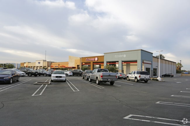
139 N Grand Ave, Covina, CA 91724

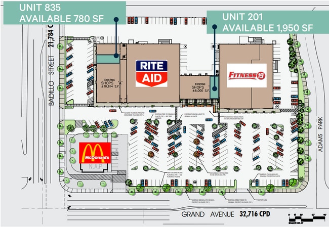
Current Lease Availabilities
NEARBY LISTINGS FOR SALE OR LEASE
Property Detail
139 N Grand Ave
8429-015-028
21226
Regionalshoppingcenterormallwithanchorstore
LOT COM AT INTERSECTION OF E LINE OF TR NO 21226 WITH N LINE OF BADILLO ST TH N ON SD E LINE TO S LINE OF ADAMS PARK DR TH E THEREON AND S ON W LINE OF GRAND SEE ASSESSOR MAPBOOK FOR MISSING PORTIONNO 1089 AND PART OF RANCHO LA PUENTE
X
Los Angeles
06071C8600J
California
2024
5.18 AC
2025
Eastern SGV
403722
Los Angeles
50,268 SF
Los Angeles-Long Beach-Glendale, CA
DEMOGRAPHICS near 139 N Grand Ave
1 Mile
3 Mile
5 Mile
2024 Total Population
23,493
161,759
377,094
2029 Population
22,712
155,901
363,651
Pop Growth 2024-2029
(3.32%)
(3.62%)
(3.56%)
Average Age
39
40
40
2024 Total Households
7,857
50,401
114,305
HH Growth 2024-2029
(3.58%)
(3.89%)
(3.83%)
Median Household Inc
$81,290
$88,828
$90,990
Avg Household Size
3.00
3.10
3.20
2024 Avg HH Vehicles
2.00
2.00
2.00
Median Home Value
$713,943
$708,975
$716,552
Median Year Built
1961
1962
1966
Nearby Places
Map Layers
Map Styles
 Street
 Aerial
- Restaurants
- Banks
- Shops
- Fitness
- Groceries
PUBLIC TRANSPORTATION
COMMUTER RAIL
Covina (San Bernardino Line - Southern California Regional Rail Authority (Metrolink))
DRIVE
WALK
Distance
Covina (San Bernardino Line - Southern California Regional Rail Authority (Metrolink))
3 min
1.5 mi
Baldwin Park (San Bernardino Line - Southern California Regional Rail Authority (Metrolink))
DRIVE
WALK
Distance
Baldwin Park (San Bernardino Line - Southern California Regional Rail Authority (Metrolink))
8 min
5.0 mi
AIRPORT
Ontario International
DRIVE
WALK
Distance
Ontario International
25 min
18.5 mi
Long Beach (Daugherty Field)
DRIVE
WALK
Distance
Long Beach (Daugherty Field)
42 min
31.9 mi
John Wayne/Orange County
DRIVE
WALK
Distance
John Wayne/Orange County
43 min
33.2 mi
Freight Ports
Port of Long Beach
DRIVE
WALK
Distance
Port of Long Beach
48 min
37.6 mi
Nearby Properties
Address
Land Use
TOTAL SIZE
Lot Size
Zoning
Address
Land Use
TOTAL SIZE
Lot Size
Zoning
83,337 SF
38.49 AC
WCCR*
Address
Land Use
TOTAL SIZE
Lot Size
Zoning
533,650 SF
5.27 AC
GDCM
Address
Land Use
TOTAL SIZE
Lot Size
Zoning
190,824 SF
8.21 AC
WCR3-MF20*
Address
Land Use
TOTAL SIZE
Lot Size
Zoning
748,778 SF
11.48 AC
CVC3A*
Address
Land Use
TOTAL SIZE
Lot Size
Zoning
862,213 SF
21.22 AC
WCSP
Address
Land Use
TOTAL SIZE
Lot Size
Zoning
110,640 SF
2.94 AC
GDMS
Address
Land Use
TOTAL SIZE
Lot Size
Zoning
63,919 SF
2.97 AC
CVCP*
Address
Land Use
TOTAL SIZE
Lot Size
Zoning
141,780 SF
7.76 AC
CVRD
Address
Land Use
TOTAL SIZE
Lot Size
Zoning
154,820 SF
3.68 AC
WCRA
Address
Land Use
TOTAL SIZE
Lot Size
Zoning
459,461 SF
1.40 AC
WCCR*
Address
Land Use
TOTAL SIZE
Lot Size
Zoning
294,391 SF
16.90 AC
WCC5*
Address
Land Use
TOTAL SIZE
Lot Size
Zoning
108,544 SF
6.24 AC
LCC4*
Address
Land Use
TOTAL SIZE
Lot Size
Zoning
104,253 SF
2.88 AC
CVRD2000*
Address
Land Use
TOTAL SIZE
Lot Size
Zoning
184,800 SF
4.73 AC
CVTCP*
Address
Land Use
TOTAL SIZE
Lot Size
Zoning
105,936 SF
5.24 AC
WCR3-MF20*
Address
Land Use
TOTAL SIZE
Lot Size
Zoning
90,786 SF
1.66 AC
CVE5 & PCD
Address
Land Use
TOTAL SIZE
Lot Size
Zoning
110,364 SF
6.48 AC
GDC3
Address
Land Use
TOTAL SIZE
Lot Size
Zoning
66,831 SF
6.01 AC
GDC_RT66SP
Address
Land Use
TOTAL SIZE
Lot Size
Zoning
155,907 SF
4.38 AC
CVR3-RD150
Address
Land Use
TOTAL SIZE
Lot Size
Zoning
117,847 SF
10 AC
CVC3AY
Address
Land Use
TOTAL SIZE
Lot Size
Zoning
94,446 SF
4.97 AC
CVA1PCD*
Address
Land Use
TOTAL SIZE
Lot Size
Zoning
224,675 SF
3.50 AC
WCCS*
Address
Land Use
TOTAL SIZE
Lot Size
Zoning
76,220 SF
2.85 AC
AZR3B*
Address
Land Use
TOTAL SIZE
Lot Size
Zoning
160,160 SF
8.32 AC
GDR3
Address
Land Use
TOTAL SIZE
Lot Size
Zoning
63,600 SF
4.58 AC
CVC3A*
Address
Land Use
TOTAL SIZE
Lot Size
Zoning
78,852 SF
2.28 AC
WCR3-MF20*
Address
Land Use
TOTAL SIZE
Lot Size
Zoning
106,660 SF
3.75 AC
CVR3-RD150
Address
Land Use
TOTAL SIZE
Lot Size
Zoning
66,948 SF
2.37 AC
WCR3-MF20*
Address
Land Use
TOTAL SIZE
Lot Size
Zoning
119,787 SF
3.17 AC
CVR3-RD125
Address
Land Use
TOTAL SIZE
Lot Size
Zoning
67,160 SF
3.34 AC
AZR3A*
The World's #1 Commercial Real Estate Marketplace
Connect with us
© 2026 CoStar Group
The information above has been obtained from sources believed reliable. While we do not doubt its accuracy we have not verified it and make no guarantee, warranty or representation about it. It is your responsibility to independently confirm its accuracy and completeness. Any projections, opinions, assumptions, or estimates used are for example only and do not represent the current or future performance of the property. The value of this transaction to you depends on tax and other factors which should be evaluated by your tax, financial, and legal advisors. You and your advisors should conduct a careful, independent investigation of the property to determine to your satisfaction the suitability of the property for your needs.