Property Record
119 Buick St, Lafayette, LA 70501
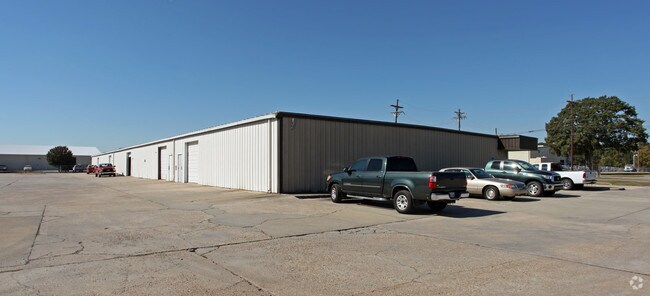


Property Detail
119 Buick St
6020532
SEC 98 T10S R5E (4.309 AC) (408X460)
Warehouse
LAFAYETTE
B and X Area of moderate flood hazard, usually the area between the limits of the 100-year and 500-year floods.
Louisiana
2025
4.31 AC
2025
Greater Lafayette
001100
Lafayette
78,000 SF
Lafayette, LA
NEARBY LISTINGS FOR SALE OR LEASE
DEMOGRAPHICS near 119 Buick St
1 mile
3 mile
5 mile
2025 Total Population
1,552
29,803
93,586
2030 Population
1,656
31,194
97,790
Pop Growth 2025-2030
+ 6.70%
+ 4.67%
+ 4.49%
Average Age
39
39
39
2025 Total Households
625
12,554
39,307
HH Growth 2025-2030
+ 6.88%
+ 4.83%
+ 4.63%
Median Household Inc
$42,999
$68,284
$74,099
Avg Household Size
2.40
2.30
2.30
2025 Avg HH Vehicles
2.00
2.00
2.00
Median Home Value
$202,885
$269,612
$294,175
Median Year Built
1996
1992
1990
Nearby Places
Map Layers
Map Styles
 Street
 Aerial
Layers
 Traffic
 Biking
Places
Listings with unknown addresses are not visible on the map
- Restaurants
- Banks
- Shops
- Fitness
- Groceries
PUBLIC TRANSPORTATION
COMMUTER RAIL
Lafayette Amtrak Station (Sunset Limited - Amtrak)
Drive
Walk
Distance
Lafayette Amtrak Station (Sunset Limited - Amtrak)
9 min
5.4 mi
AIRPORT
Lafayette Regional/Paul Fournet Field
Drive
Walk
Distance
Lafayette Regional/Paul Fournet Field
8 min
4.4 mi
Freight Ports
Port of Iberia
Drive
Walk
Distance
Port of Iberia
25 min
18.8 mi
Nearby Properties
Address
Land Use
TOTAL SIZE
Lot Size
Zoning
Address
Land Use
TOTAL SIZE
Lot Size
Zoning
273,165 SF
15.14 AC
Address
Land Use
TOTAL SIZE
Lot Size
Zoning
20,775 SF
11.04 AC
Address
Land Use
TOTAL SIZE
Lot Size
Zoning
158,272 SF
Address
Land Use
TOTAL SIZE
Lot Size
Zoning
145,412 SF
0.01 AC
Address
Land Use
TOTAL SIZE
Lot Size
Zoning
11,778 SF
15.25 AC
Address
Land Use
TOTAL SIZE
Lot Size
Zoning
98,973 SF
9.91 AC
Address
Land Use
TOTAL SIZE
Lot Size
Zoning
900 SF
12.41 AC
Address
Land Use
TOTAL SIZE
Lot Size
Zoning
210,169 SF
20.75 AC
Address
Land Use
TOTAL SIZE
Lot Size
Zoning
1,760 SF
13.87 AC
Address
Land Use
TOTAL SIZE
Lot Size
Zoning
194,912 SF
13.73 AC
Address
Land Use
TOTAL SIZE
Lot Size
Zoning
205,096 SF
21.71 AC
Address
Land Use
TOTAL SIZE
Lot Size
Zoning
Address
Land Use
TOTAL SIZE
Lot Size
Zoning
200,194 SF
30.80 AC
Address
Land Use
TOTAL SIZE
Lot Size
Zoning
9.02 AC
Address
Land Use
TOTAL SIZE
Lot Size
Zoning
5,625 SF
25.86 AC
Address
Land Use
TOTAL SIZE
Lot Size
Zoning
19,424 SF
8.82 AC
Address
Land Use
TOTAL SIZE
Lot Size
Zoning
141,600 SF
24.31 AC
Address
Land Use
TOTAL SIZE
Lot Size
Zoning
122,362 SF
4.28 AC
Address
Land Use
TOTAL SIZE
Lot Size
Zoning
91,619 SF
5.48 AC
Address
Land Use
TOTAL SIZE
Lot Size
Zoning
21,232 SF
6.63 AC
Address
Land Use
TOTAL SIZE
Lot Size
Zoning
69,328 SF
27.85 AC
Address
Land Use
TOTAL SIZE
Lot Size
Zoning
7,020 SF
222.16 AC
Address
Land Use
TOTAL SIZE
Lot Size
Zoning
25,886 SF
8.39 AC
Address
Land Use
TOTAL SIZE
Lot Size
Zoning
22,489 SF
6.52 AC
Address
Land Use
TOTAL SIZE
Lot Size
Zoning
107,705 SF
3.77 AC
Address
Land Use
TOTAL SIZE
Lot Size
Zoning
50,093 SF
1.87 AC
Address
Land Use
TOTAL SIZE
Lot Size
Zoning
92,336 SF
3.68 AC
Address
Land Use
TOTAL SIZE
Lot Size
Zoning
32,258 SF
7.18 AC
Address
Land Use
TOTAL SIZE
Lot Size
Zoning
283,435 SF
39.25 AC
Address
Land Use
TOTAL SIZE
Lot Size
Zoning
4,800 SF
17.84 AC
The World's #1 Commercial Real Estate Marketplace
Connect with us
© 2026 CoStar Group
The information above has been obtained from sources believed reliable. While we do not doubt its accuracy we have not verified it and make no guarantee, warranty or representation about it. It is your responsibility to independently confirm its accuracy and completeness. Any projections, opinions, assumptions, or estimates used are for example only and do not represent the current or future performance of the property. The value of this transaction to you depends on tax and other factors which should be evaluated by your tax, financial, and legal advisors. You and your advisors should conduct a careful, independent investigation of the property to determine to your satisfaction the suitability of the property for your needs.