No Photo
Property Record
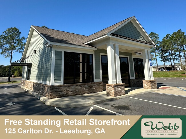
119 Carlton Dr, Leesburg, GA 31763
NEARBY LISTINGS FOR SALE OR LEASE
Property Detail
119 Carlton Dr
Albany, GA
Oakland Parkway Comm S/D
018C-498
LOT 18 OAKLAND PARKWAY COMM S/D
Medicalbuilding
Lee
X
Georgia
13177C0237D
18
2024
1.61 AC
2024
Albany/Southwest
020405
Other Market Areas
6,091 SF
DEMOGRAPHICS near 119 Carlton Dr
1 Mile
3 Mile
5 Mile
2024 Total Population
2,679
15,773
42,190
2029 Population
2,808
15,686
41,312
Pop Growth 2024-2029
+ 4.82%
(0.55%)
(2.08%)
Average Age
41
42
39
2024 Total Households
1,019
6,346
17,373
HH Growth 2024-2029
+ 5.00%
(1.01%)
(2.51%)
Median Household Inc
$99,272
$87,627
$67,737
Avg Household Size
2.50
2.40
2.40
2024 Avg HH Vehicles
2.00
2.00
2.00
Median Home Value
$242,277
$238,933
$191,765
Median Year Built
2000
1990
1987
Nearby Places
Map Layers
Map Styles
 Street
 Aerial
- Restaurants
- Banks
- Shops
- Fitness
- Groceries
PUBLIC TRANSPORTATION
AIRPORT
Southwest Georgia Regional
DRIVE
WALK
Distance
Southwest Georgia Regional
18 min
9.5 mi
Freight Ports
Port of Panama City
DRIVE
WALK
Distance
Port of Panama City
238 min
162.6 mi
SALE & LEASE HISTORY
LISTING DATE
SALE/LEASE

Jun 07, 2024
For Sale
Nearby Properties
Address
Land Use
TOTAL SIZE
Lot Size
Zoning
Address
Land Use
TOTAL SIZE
Lot Size
Zoning
126,650 SF
19.41 AC
C2
Address
Land Use
TOTAL SIZE
Lot Size
Zoning
2,659 SF
42.40 AC
COMMERCIAL
Address
Land Use
TOTAL SIZE
Lot Size
Zoning
42,880 SF
31.25 AC
R6
Address
Land Use
TOTAL SIZE
Lot Size
Zoning
186,956 SF
29.23 AC
R6
Address
Land Use
TOTAL SIZE
Lot Size
Zoning
147,258 SF
36.94 AC
C7
Address
Land Use
TOTAL SIZE
Lot Size
Zoning
224,080 SF
21.72 AC
COMMERCIAL
Address
Land Use
TOTAL SIZE
Lot Size
Zoning
131,385 SF
21.89 AC
C3
Address
Land Use
TOTAL SIZE
Lot Size
Zoning
125,299 SF
14.05 AC
C7
Address
Land Use
TOTAL SIZE
Lot Size
Zoning
88,144 SF
12.47 AC
C2
Address
Land Use
TOTAL SIZE
Lot Size
Zoning
95,923 SF
8.53 AC
C2
Address
Land Use
TOTAL SIZE
Lot Size
Zoning
107,500 SF
11.27 AC
C2
Address
Land Use
TOTAL SIZE
Lot Size
Zoning
156,000 SF
24.96 AC
INDUSTRIAL
Address
Land Use
TOTAL SIZE
Lot Size
Zoning
129,973 SF
21.89 AC
C3
Address
Land Use
TOTAL SIZE
Lot Size
Zoning
35,650 SF
3.73 AC
C5
Address
Land Use
TOTAL SIZE
Lot Size
Zoning
44,671 SF
4 AC
C2
Address
Land Use
TOTAL SIZE
Lot Size
Zoning
3,002 SF
9.64 AC
COMMERCIAL
Address
Land Use
TOTAL SIZE
Lot Size
Zoning
31,835 SF
30 AC
COMMERCIAL
Address
Land Use
TOTAL SIZE
Lot Size
Zoning
5,768 SF
16.40 AC
R6
Address
Land Use
TOTAL SIZE
Lot Size
Zoning
32,000 SF
14.19 AC
R1A
Address
Land Use
TOTAL SIZE
Lot Size
Zoning
73,610 SF
7.34 AC
C2
Address
Land Use
TOTAL SIZE
Lot Size
Zoning
56,014 SF
8.56 AC
C7
Address
Land Use
TOTAL SIZE
Lot Size
Zoning
126,650 SF
0.96 AC
C2
Address
Land Use
TOTAL SIZE
Lot Size
Zoning
60,780 SF
2.18 AC
C2
Address
Land Use
TOTAL SIZE
Lot Size
Zoning
45,440 SF
4.42 AC
C7
Address
Land Use
TOTAL SIZE
Lot Size
Zoning
12,462 SF
10.53 AC
RESIDENTIA
Address
Land Use
TOTAL SIZE
Lot Size
Zoning
97,028 SF
7.86 AC
C7
Address
Land Use
TOTAL SIZE
Lot Size
Zoning
23,800 SF
4.79 AC
C2
Address
Land Use
TOTAL SIZE
Lot Size
Zoning
100,392 SF
11.25 AC
C3
Address
Land Use
TOTAL SIZE
Lot Size
Zoning
68,592 SF
6.80 AC
C2
Address
Land Use
TOTAL SIZE
Lot Size
Zoning
18,530 SF
33.51 AC
COMMERCIAL
The World's #1 Commercial Real Estate Marketplace
Connect with us
© 2026 CoStar Group
The information above has been obtained from sources believed reliable. While we do not doubt its accuracy we have not verified it and make no guarantee, warranty or representation about it. It is your responsibility to independently confirm its accuracy and completeness. Any projections, opinions, assumptions, or estimates used are for example only and do not represent the current or future performance of the property. The value of this transaction to you depends on tax and other factors which should be evaluated by your tax, financial, and legal advisors. You and your advisors should conduct a careful, independent investigation of the property to determine to your satisfaction the suitability of the property for your needs.