Property Record
119 Commonwealth Dr, Warrendale, PA 15086


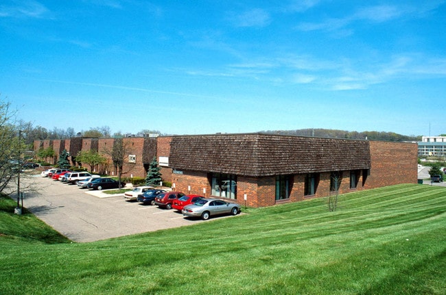

Property Detail
119 Commonwealth Dr
Pittsburgh, PA
THORNHILL INDUSTRIAL PARK 5TH ADDN TO 1ST PLAN PARCEL #4-A = 474X300X463.94 (3.771 ALD) THORNHILL INDUSTRIAL PARK 5TH ADDN TO 1ST
2371-M-00001-0000-00
Allegheny
Warehouse
Pennsylvania
AE The base floodplain where base flood elevations are provided. AE Zones are now used on new format FIRMs instead of A1-A30 Zones.
1
2024
11.95 AC
2025
North Pittsburgh
411001
Pittsburgh
NEARBY LISTINGS FOR SALE OR LEASE
DEMOGRAPHICS near 119 Commonwealth Dr
1 mile
3 mile
5 mile
2024 Total Population
2,442
36,318
79,625
2029 Population
2,464
36,561
79,696
Pop Growth 2024-2029
+ 0.90%
+ 0.67%
+ 0.09%
Average Age
40
41
41
2024 Total Households
947
14,130
30,170
HH Growth 2024-2029
+ 1.06%
+ 0.91%
+ 0.22%
Median Household Inc
$132,115
$124,230
$134,571
Avg Household Size
2.50
2.50
2.60
2024 Avg HH Vehicles
2.00
2.00
2.00
Median Home Value
$497,871
$420,494
$440,986
Median Year Built
2005
1994
1995
Nearby Places
Map Layers
Map Styles
 Street
 Aerial
Transit
 Traffic
 Biking
Places
Listings with unknown addresses are not visible on the map
- Restaurants
- Banks
- Shops
- Fitness
- Groceries
PUBLIC TRANSPORTATION
AIRPORT
Pittsburgh International
Drive
Walk
Distance
Pittsburgh International
37 min
19.4 mi
SALE & LEASE HISTORY
LISTING DATE
SALE/LEASE

Jul 27, 2022
For Lease
Nearby Properties
Address
Land Use
TOTAL SIZE
Lot Size
Zoning
Address
Land Use
TOTAL SIZE
Lot Size
Zoning
80.58 AC
Address
Land Use
TOTAL SIZE
Lot Size
Zoning
30.03 AC
Address
Land Use
TOTAL SIZE
Lot Size
Zoning
101.14 AC
Address
Land Use
TOTAL SIZE
Lot Size
Zoning
47,000 SF
52.99 AC
Address
Land Use
TOTAL SIZE
Lot Size
Zoning
18.78 AC
Address
Land Use
TOTAL SIZE
Lot Size
Zoning
23.48 AC
Address
Land Use
TOTAL SIZE
Lot Size
Zoning
10.62 AC
Address
Land Use
TOTAL SIZE
Lot Size
Zoning
16.90 AC
Address
Land Use
TOTAL SIZE
Lot Size
Zoning
Address
Land Use
TOTAL SIZE
Lot Size
Zoning
10.62 AC
Address
Land Use
TOTAL SIZE
Lot Size
Zoning
Address
Land Use
TOTAL SIZE
Lot Size
Zoning
12.44 AC
Address
Land Use
TOTAL SIZE
Lot Size
Zoning
9.04 AC
Address
Land Use
TOTAL SIZE
Lot Size
Zoning
7.58 AC
Address
Land Use
TOTAL SIZE
Lot Size
Zoning
1.59 AC
Address
Land Use
TOTAL SIZE
Lot Size
Zoning
20.84 AC
Address
Land Use
TOTAL SIZE
Lot Size
Zoning
13.59 AC
Address
Land Use
TOTAL SIZE
Lot Size
Zoning
814 SF
10.79 AC
Address
Land Use
TOTAL SIZE
Lot Size
Zoning
6,240 SF
40.21 AC
Address
Land Use
TOTAL SIZE
Lot Size
Zoning
1,980 SF
2.97 AC
Address
Land Use
TOTAL SIZE
Lot Size
Zoning
32.41 AC
Address
Land Use
TOTAL SIZE
Lot Size
Zoning
Address
Land Use
TOTAL SIZE
Lot Size
Zoning
1,431 SF
40.30 AC
Address
Land Use
TOTAL SIZE
Lot Size
Zoning
88,000 SF
19.74 AC
Address
Land Use
TOTAL SIZE
Lot Size
Zoning
5.34 AC
Address
Land Use
TOTAL SIZE
Lot Size
Zoning
8.26 AC
Address
Land Use
TOTAL SIZE
Lot Size
Zoning
13.10 AC
Address
Land Use
TOTAL SIZE
Lot Size
Zoning
2,350 SF
11.04 AC
Address
Land Use
TOTAL SIZE
Lot Size
Zoning
The World's #1 Commercial Real Estate Marketplace
Connect with us
© 2026 CoStar Group
The information above has been obtained from sources believed reliable. While we do not doubt its accuracy we have not verified it and make no guarantee, warranty or representation about it. It is your responsibility to independently confirm its accuracy and completeness. Any projections, opinions, assumptions, or estimates used are for example only and do not represent the current or future performance of the property. The value of this transaction to you depends on tax and other factors which should be evaluated by your tax, financial, and legal advisors. You and your advisors should conduct a careful, independent investigation of the property to determine to your satisfaction the suitability of the property for your needs.