Property Record
119 E 22Nd Ave, Homestead, PA 15120


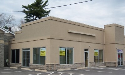
Property Detail
119 E 22Nd Ave
Pittsburgh, PA
WEST PLAN PTS 173-174-175 LOT 180X110 IN ALL 22 ND AVE 1 STY CONV STORE
0131-M-00133-0000-00
ALLEGHENY
Storebuilding
Pennsylvania
B and X Area of moderate flood hazard, usually the area between the limits of the 100-year and 500-year floods.
133
2024
0.46 AC
2025
South Pittsburgh/Rte 51
484600
Pittsburgh
NEARBY LISTINGS FOR SALE OR LEASE
DEMOGRAPHICS near 119 E 22Nd Ave
1 mile
3 mile
5 mile
2025 Total Population
14,424
89,277
314,903
2030 Population
14,454
88,479
314,170
Pop Growth 2025-2030
+ 0.21%
(0.89%)
(0.23%)
Average Age
43
42
40
2025 Total Households
6,858
42,086
143,285
HH Growth 2025-2030
+ 0.23%
(0.94%)
(0.37%)
Median Household Inc
$56,851
$64,696
$57,152
Avg Household Size
2.10
2.10
2.00
2025 Avg HH Vehicles
1.00
1.00
1.00
Median Home Value
$120,413
$176,830
$170,146
Median Year Built
1951
1949
1950
Nearby Places
Map Layers
Map Styles
 Street
 Aerial
Layers
 Traffic
 Biking
Places
Listings with unknown addresses are not visible on the map
- Restaurants
- Banks
- Shops
- Fitness
- Groceries
PUBLIC TRANSPORTATION
COMMUTER RAIL
Drive
Walk
Distance
17 min
7.4 mi
AIRPORT
Pittsburgh International
Drive
Walk
Distance
Pittsburgh International
42 min
23.9 mi
Arnold Palmer Regional
Drive
Walk
Distance
Arnold Palmer Regional
63 min
33.3 mi
Nearby Properties
Address
Land Use
TOTAL SIZE
Lot Size
Zoning
Address
Land Use
TOTAL SIZE
Lot Size
Zoning
Address
Land Use
TOTAL SIZE
Lot Size
Zoning
18.66 AC
Address
Land Use
TOTAL SIZE
Lot Size
Zoning
Address
Land Use
TOTAL SIZE
Lot Size
Zoning
7.79 AC
Address
Land Use
TOTAL SIZE
Lot Size
Zoning
15.90 AC
Address
Land Use
TOTAL SIZE
Lot Size
Zoning
Address
Land Use
TOTAL SIZE
Lot Size
Zoning
9.69 AC
Address
Land Use
TOTAL SIZE
Lot Size
Zoning
23.87 AC
Address
Land Use
TOTAL SIZE
Lot Size
Zoning
Address
Land Use
TOTAL SIZE
Lot Size
Zoning
1.39 AC
Address
Land Use
TOTAL SIZE
Lot Size
Zoning
162.82 AC
Address
Land Use
TOTAL SIZE
Lot Size
Zoning
2.92 AC
Address
Land Use
TOTAL SIZE
Lot Size
Zoning
0.93 AC
Address
Land Use
TOTAL SIZE
Lot Size
Zoning
10.86 AC
Address
Land Use
TOTAL SIZE
Lot Size
Zoning
19.85 AC
Address
Land Use
TOTAL SIZE
Lot Size
Zoning
121.64 AC
Address
Land Use
TOTAL SIZE
Lot Size
Zoning
Address
Land Use
TOTAL SIZE
Lot Size
Zoning
Address
Land Use
TOTAL SIZE
Lot Size
Zoning
14.79 AC
Address
Land Use
TOTAL SIZE
Lot Size
Zoning
12.51 AC
Address
Land Use
TOTAL SIZE
Lot Size
Zoning
Address
Land Use
TOTAL SIZE
Lot Size
Zoning
17.52 AC
Address
Land Use
TOTAL SIZE
Lot Size
Zoning
19.54 AC
Address
Land Use
TOTAL SIZE
Lot Size
Zoning
Address
Land Use
TOTAL SIZE
Lot Size
Zoning
48.07 AC
Address
Land Use
TOTAL SIZE
Lot Size
Zoning
3.54 AC
Address
Land Use
TOTAL SIZE
Lot Size
Zoning
Address
Land Use
TOTAL SIZE
Lot Size
Zoning
Address
Land Use
TOTAL SIZE
Lot Size
Zoning
Address
Land Use
TOTAL SIZE
Lot Size
Zoning
18.09 AC
The World's #1 Commercial Real Estate Marketplace
Connect with us
© 2026 CoStar Group
The information above has been obtained from sources believed reliable. While we do not doubt its accuracy we have not verified it and make no guarantee, warranty or representation about it. It is your responsibility to independently confirm its accuracy and completeness. Any projections, opinions, assumptions, or estimates used are for example only and do not represent the current or future performance of the property. The value of this transaction to you depends on tax and other factors which should be evaluated by your tax, financial, and legal advisors. You and your advisors should conduct a careful, independent investigation of the property to determine to your satisfaction the suitability of the property for your needs.