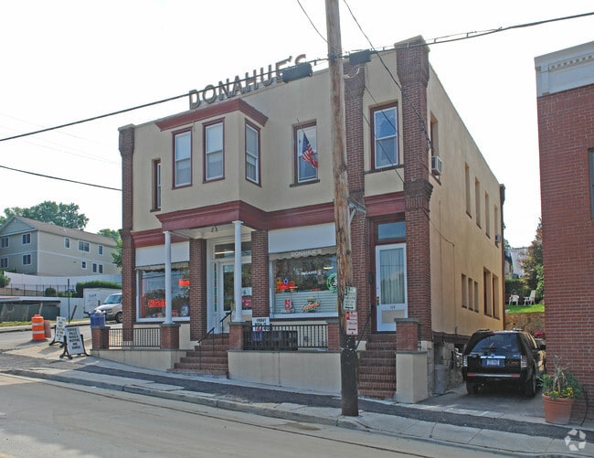
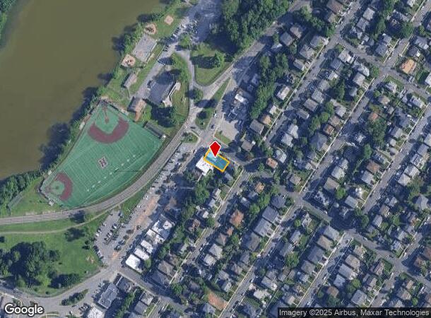
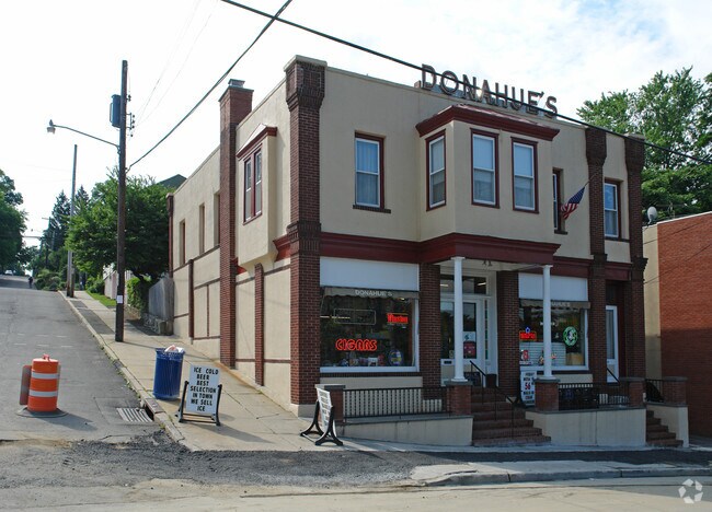
Property Record
119 Lake St, West Harrison, NY 10604
NEARBY LISTINGS FOR SALE OR LEASE
Property Detail
119 Lake St
2801-000-871-00000-000-0003
Map #1 Silver Lake Park
Commercialbuilding
Westchester
X
New York
36119C0286F
3
2025
0.11 AC
2024
East I-287 Corridor
008700
Westchester/So Connecticut
3,687 SF
New York-Jersey City-White Plains, NY-NJ
DEMOGRAPHICS near 119 Lake St
1 Mile
3 Mile
5 Mile
2024 Total Population
13,535
92,881
187,351
2029 Population
13,081
91,862
184,220
Pop Growth 2024-2029
(3.35%)
(1.10%)
(1.67%)
Average Age
41
42
42
2024 Total Households
5,362
36,157
68,573
HH Growth 2024-2029
(3.41%)
(1.08%)
(1.67%)
Median Household Inc
$109,357
$120,013
$136,806
Avg Household Size
2.40
2.40
2.60
2024 Avg HH Vehicles
2.00
2.00
2.00
Median Home Value
$645,464
$640,255
$735,294
Median Year Built
1957
1962
1960
Nearby Places
- Restaurants
- Banks
- Shops
- Fitness
- Groceries
PUBLIC TRANSPORTATION
COMMUTER RAIL
White Plains Station (Harlem Line - Metro-North Commuter Railroad Company (Metro-North))
DRIVE
WALK
Distance
White Plains Station (Harlem Line - Metro-North Commuter Railroad Company (Metro-North))
4 min
1.9 mi
North White Plains Station (Harlem Line - Metro-North Commuter Railroad Company (Metro-North))
DRIVE
WALK
Distance
North White Plains Station (Harlem Line - Metro-North Commuter Railroad Company (Metro-North))
4 min
2.3 mi
AIRPORT
Westchester County
DRIVE
WALK
Distance
Westchester County
9 min
4.6 mi
LaGuardia
DRIVE
WALK
Distance
LaGuardia
43 min
25.9 mi
John F Kennedy International
DRIVE
WALK
Distance
John F Kennedy International
49 min
33.5 mi
Freight Ports
NY - Red Hook Container Terminal
DRIVE
WALK
Distance
NY - Red Hook Container Terminal
57 min
38.6 mi
Nearby Properties
Address
Land Use
TOTAL SIZE
Lot Size
Zoning
Address
Land Use
TOTAL SIZE
Lot Size
Zoning
358.83 AC
Address
Land Use
TOTAL SIZE
Lot Size
Zoning
75.87 AC
R-20
Address
Land Use
TOTAL SIZE
Lot Size
Zoning
16.22 AC
UR
Address
Land Use
TOTAL SIZE
Lot Size
Zoning
113.12 AC
OB-1 OFFC
Address
Land Use
TOTAL SIZE
Lot Size
Zoning
7.98 AC
CA
Address
Land Use
TOTAL SIZE
Lot Size
Zoning
1,975 SF
13.80 AC
CA
Address
Land Use
TOTAL SIZE
Lot Size
Zoning
164,312 SF
4.92 AC
Z-4 AIRPRT
Address
Land Use
TOTAL SIZE
Lot Size
Zoning
29.42 AC
PUD
Address
Land Use
TOTAL SIZE
Lot Size
Zoning
10.90 AC
UR
Address
Land Use
TOTAL SIZE
Lot Size
Zoning
477.23 AC
Address
Land Use
TOTAL SIZE
Lot Size
Zoning
7.98 AC
M-14
Address
Land Use
TOTAL SIZE
Lot Size
Zoning
343,295 SF
3.68 AC
OB-1 OFFC
Address
Land Use
TOTAL SIZE
Lot Size
Zoning
5.43 AC
R-40
Address
Land Use
TOTAL SIZE
Lot Size
Zoning
320 SF
5.38 AC
LI
Address
Land Use
TOTAL SIZE
Lot Size
Zoning
1,348 SF
5.67 AC
CA
Address
Land Use
TOTAL SIZE
Lot Size
Zoning
6.09 AC
DS
Address
Land Use
TOTAL SIZE
Lot Size
Zoning
1,630 SF
2.64 AC
LOB
Address
Land Use
TOTAL SIZE
Lot Size
Zoning
88,129 SF
18.68 AC
OB-1 OFFC
Address
Land Use
TOTAL SIZE
Lot Size
Zoning
5.37 AC
R-20
Address
Land Use
TOTAL SIZE
Lot Size
Zoning
9.73 AC
OB-1
Address
Land Use
TOTAL SIZE
Lot Size
Zoning
1.21 AC
B
Address
Land Use
TOTAL SIZE
Lot Size
Zoning
8.36 AC
Address
Land Use
TOTAL SIZE
Lot Size
Zoning
39,572 SF
9.49 AC
OB-3 OFFC
Address
Land Use
TOTAL SIZE
Lot Size
Zoning
3.12 AC
LI
Address
Land Use
TOTAL SIZE
Lot Size
Zoning
3.96 AC
LI
Address
Land Use
TOTAL SIZE
Lot Size
Zoning
1,338 SF
51.60 AC
R-20
Address
Land Use
TOTAL SIZE
Lot Size
Zoning
8 AC
M-10
Address
Land Use
TOTAL SIZE
Lot Size
Zoning
45,648 SF
0.93 AC
OB-1 OFFC
Address
Land Use
TOTAL SIZE
Lot Size
Zoning
2,365 SF
3.02 AC
CA
Address
Land Use
TOTAL SIZE
Lot Size
Zoning
1,836 SF
4.39 AC
The World's #1 Commercial Real Estate Marketplace
Connect with us
© 2025 CoStar Group
The information above has been obtained from sources believed reliable. While we do not doubt its accuracy we have not verified it and make no guarantee, warranty or representation about it. It is your responsibility to independently confirm its accuracy and completeness. Any projections, opinions, assumptions, or estimates used are for example only and do not represent the current or future performance of the property. The value of this transaction to you depends on tax and other factors which should be evaluated by your tax, financial, and legal advisors. You and your advisors should conduct a careful, independent investigation of the property to determine to your satisfaction the suitability of the property for your needs.