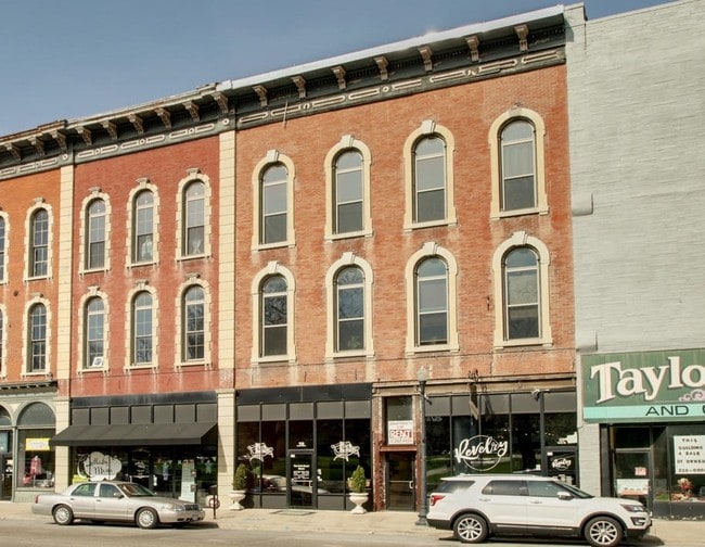
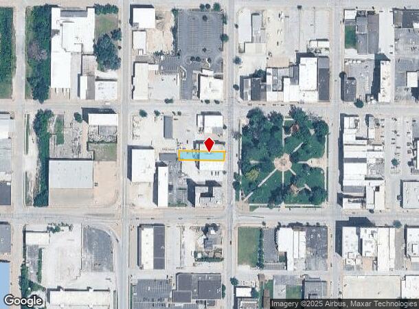
Property Record
119 N 4Th St, Quincy, IL 62301
NEARBY LISTINGS FOR SALE OR LEASE
Property Detail
119 N 4Th St
Quincy, IL-MO
Original Survey And Plat Of The City Of
23-1-0254-000-00
LOT 8 BLK 13 QUINCY SURVEY -EX S 10.33FT- S 1/2 LOT 8
Commercialnec
Adams
X
Illinois
17001C0316E
8
2024
0.18 AC
2024
Effingham/Central Illinois Area
000700
Other Market Areas
DEMOGRAPHICS near 119 N 4Th St
1 Mile
3 Mile
5 Mile
2024 Total Population
8,628
38,493
47,578
2029 Population
8,729
38,249
47,158
Pop Growth 2024-2029
+ 1.17%
(0.63%)
(0.88%)
Average Age
39
41
42
2024 Total Households
4,048
16,388
20,220
HH Growth 2024-2029
+ 0.82%
(0.74%)
(0.98%)
Median Household Inc
$33,353
$50,986
$55,574
Avg Household Size
2.00
2.20
2.20
2024 Avg HH Vehicles
1.00
2.00
2.00
Median Home Value
$73,378
$129,844
$145,133
Median Year Built
1948
1956
1962
Nearby Places
Map Layers
Map Styles
 Street
 Aerial
- Restaurants
- Banks
- Shops
- Fitness
- Groceries
PUBLIC TRANSPORTATION
COMMUTER RAIL
Quincy Amtrak Station (Carl Sandburg - Amtrak, Illinois Zephyr - Amtrak)
DRIVE
WALK
Distance
Quincy Amtrak Station (Carl Sandburg - Amtrak, Illinois Zephyr - Amtrak)
7 min
3.9 mi
Freight Ports
Port Milwaukee
DRIVE
WALK
Distance
Port Milwaukee
404 min
353.6 mi
SALE & LEASE HISTORY
LISTING DATE
SALE/LEASE

Nov 09, 2018
For Sale
Jun 15, 2018
For Sale
Nearby Properties
Address
Land Use
TOTAL SIZE
Lot Size
Zoning
Address
Land Use
TOTAL SIZE
Lot Size
Zoning
39.60 AC
Address
Land Use
TOTAL SIZE
Lot Size
Zoning
0.49 AC
Address
Land Use
TOTAL SIZE
Lot Size
Zoning
0.79 AC
Address
Land Use
TOTAL SIZE
Lot Size
Zoning
14.91 AC
Address
Land Use
TOTAL SIZE
Lot Size
Zoning
1.04 AC
Address
Land Use
TOTAL SIZE
Lot Size
Zoning
1.65 AC
Address
Land Use
TOTAL SIZE
Lot Size
Zoning
9.67 AC
Address
Land Use
TOTAL SIZE
Lot Size
Zoning
0.23 AC
Address
Land Use
TOTAL SIZE
Lot Size
Zoning
15.46 AC
Address
Land Use
TOTAL SIZE
Lot Size
Zoning
1.78 AC
Address
Land Use
TOTAL SIZE
Lot Size
Zoning
41.26 AC
Address
Land Use
TOTAL SIZE
Lot Size
Zoning
7.35 AC
Address
Land Use
TOTAL SIZE
Lot Size
Zoning
16.50 AC
Address
Land Use
TOTAL SIZE
Lot Size
Zoning
8.74 AC
Address
Land Use
TOTAL SIZE
Lot Size
Zoning
9.67 AC
Address
Land Use
TOTAL SIZE
Lot Size
Zoning
13.85 AC
Address
Land Use
TOTAL SIZE
Lot Size
Zoning
0.07 AC
Address
Land Use
TOTAL SIZE
Lot Size
Zoning
9.09 AC
Address
Land Use
TOTAL SIZE
Lot Size
Zoning
32.12 AC
Address
Land Use
TOTAL SIZE
Lot Size
Zoning
8.10 AC
Address
Land Use
TOTAL SIZE
Lot Size
Zoning
39.97 AC
Address
Land Use
TOTAL SIZE
Lot Size
Zoning
23.26 AC
Address
Land Use
TOTAL SIZE
Lot Size
Zoning
16.65 AC
Address
Land Use
TOTAL SIZE
Lot Size
Zoning
12.69 AC
Address
Land Use
TOTAL SIZE
Lot Size
Zoning
9.68 AC
Address
Land Use
TOTAL SIZE
Lot Size
Zoning
1.65 AC
Address
Land Use
TOTAL SIZE
Lot Size
Zoning
3.58 AC
Address
Land Use
TOTAL SIZE
Lot Size
Zoning
0.69 AC
Address
Land Use
TOTAL SIZE
Lot Size
Zoning
8.67 AC
Address
Land Use
TOTAL SIZE
Lot Size
Zoning
2.79 AC
The World's #1 Commercial Real Estate Marketplace
Connect with us
© 2025 CoStar Group
The information above has been obtained from sources believed reliable. While we do not doubt its accuracy we have not verified it and make no guarantee, warranty or representation about it. It is your responsibility to independently confirm its accuracy and completeness. Any projections, opinions, assumptions, or estimates used are for example only and do not represent the current or future performance of the property. The value of this transaction to you depends on tax and other factors which should be evaluated by your tax, financial, and legal advisors. You and your advisors should conduct a careful, independent investigation of the property to determine to your satisfaction the suitability of the property for your needs.