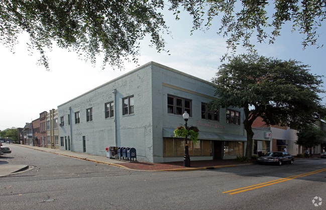
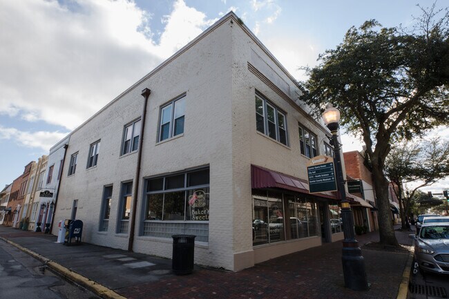
Property Record
119 N Main St, Sumter, SC 29150

Property Detail
119 N Main St
249-09-01-014
G5-68 0.16 AC
Commercialnec
Sumter
B and X Area of moderate flood hazard, usually the area between the limits of the 100-year and 500-year floods.
South Carolina
2023
0.16 AC
2025
Orangeburg/Sumter
001300
Other Market Areas
5,429 SF
Sumter, SC
NEARBY LISTINGS FOR SALE OR LEASE
DEMOGRAPHICS near 119 N Main St
1 mile
3 mile
5 mile
2025 Total Population
5,870
34,106
55,018
2030 Population
5,900
34,081
54,656
Pop Growth 2025-2030
+ 0.51%
(0.07%)
(0.66%)
Average Age
41
40
40
2025 Total Households
2,565
14,085
22,433
HH Growth 2025-2030
+ 0.58%
(0.01%)
(0.56%)
Median Household Inc
$30,393
$44,012
$54,569
Avg Household Size
2.10
2.30
2.40
2025 Avg HH Vehicles
1.00
2.00
2.00
Median Home Value
$120,736
$150,000
$190,620
Median Year Built
1970
1977
1981
Nearby Places
Map Layers
Map Styles
 Street
 Aerial
Transit
 Traffic
 Biking
Places
Listings with unknown addresses are not visible on the map
- Restaurants
- Banks
- Shops
- Fitness
- Groceries
SALE & LEASE HISTORY
LISTING DATE
SALE/LEASE

Feb 04, 2019
For Lease
Feb 01, 2019
For Lease
Aug 07, 2017
For Lease
Apr 03, 2017
For Lease
Nearby Properties
Address
Land Use
TOTAL SIZE
Lot Size
Zoning
Address
Land Use
TOTAL SIZE
Lot Size
Zoning
65,367 SF
11.59 AC
COMM
Address
Land Use
TOTAL SIZE
Lot Size
Zoning
128,942 SF
160.10 AC
Address
Land Use
TOTAL SIZE
Lot Size
Zoning
172,485 SF
29.12 AC
COMM
Address
Land Use
TOTAL SIZE
Lot Size
Zoning
54,133 SF
8.72 AC
Address
Land Use
TOTAL SIZE
Lot Size
Zoning
29,235 SF
21.18 AC
G-C
Address
Land Use
TOTAL SIZE
Lot Size
Zoning
121,695 SF
14.82 AC
COMM
Address
Land Use
TOTAL SIZE
Lot Size
Zoning
27,515 SF
8.57 AC
R
Address
Land Use
TOTAL SIZE
Lot Size
Zoning
85,300 SF
8.25 AC
Address
Land Use
TOTAL SIZE
Lot Size
Zoning
39,234 SF
9.40 AC
G-C
Address
Land Use
TOTAL SIZE
Lot Size
Zoning
82,571 SF
18 AC
Address
Land Use
TOTAL SIZE
Lot Size
Zoning
129,767 SF
28 AC
Address
Land Use
TOTAL SIZE
Lot Size
Zoning
75,615 SF
15 AC
R
Address
Land Use
TOTAL SIZE
Lot Size
Zoning
1 SF
8.72 AC
MFR
Address
Land Use
TOTAL SIZE
Lot Size
Zoning
98,134 SF
57.70 AC
I-1
Address
Land Use
TOTAL SIZE
Lot Size
Zoning
46,959 SF
4.43 AC
G-C
Address
Land Use
TOTAL SIZE
Lot Size
Zoning
6.54 AC
I-1
Address
Land Use
TOTAL SIZE
Lot Size
Zoning
49,894 SF
5.01 AC
Address
Land Use
TOTAL SIZE
Lot Size
Zoning
56,294 SF
31.71 AC
R-6
Address
Land Use
TOTAL SIZE
Lot Size
Zoning
15,666 SF
2.80 AC
COMM
Address
Land Use
TOTAL SIZE
Lot Size
Zoning
29,454 SF
4.62 AC
R
Address
Land Use
TOTAL SIZE
Lot Size
Zoning
9,896 SF
1.66 AC
COMM
Address
Land Use
TOTAL SIZE
Lot Size
Zoning
25,333 SF
3.72 AC
COMM
Address
Land Use
TOTAL SIZE
Lot Size
Zoning
73,036 SF
10.59 AC
Address
Land Use
TOTAL SIZE
Lot Size
Zoning
61,285 SF
6.60 AC
Address
Land Use
TOTAL SIZE
Lot Size
Zoning
1 SF
2.17 AC
CBD
Address
Land Use
TOTAL SIZE
Lot Size
Zoning
35,631 SF
5 AC
Address
Land Use
TOTAL SIZE
Lot Size
Zoning
29,920 SF
5 AC
R
Address
Land Use
TOTAL SIZE
Lot Size
Zoning
1 SF
10.81 AC
I-1
Address
Land Use
TOTAL SIZE
Lot Size
Zoning
46,432 SF
7.59 AC
GC
Address
Land Use
TOTAL SIZE
Lot Size
Zoning
31,703 SF
6.18 AC
The World's #1 Commercial Real Estate Marketplace
Connect with us
© 2026 CoStar Group
The information above has been obtained from sources believed reliable. While we do not doubt its accuracy we have not verified it and make no guarantee, warranty or representation about it. It is your responsibility to independently confirm its accuracy and completeness. Any projections, opinions, assumptions, or estimates used are for example only and do not represent the current or future performance of the property. The value of this transaction to you depends on tax and other factors which should be evaluated by your tax, financial, and legal advisors. You and your advisors should conduct a careful, independent investigation of the property to determine to your satisfaction the suitability of the property for your needs.