Property Record
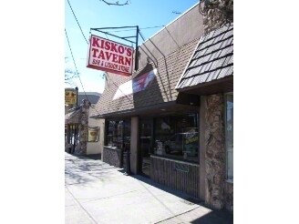
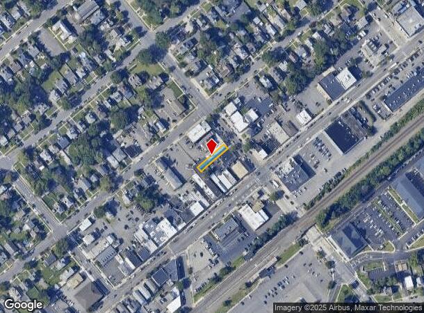
119 N Washington Ave, Dunellen, NJ 08812
NEARBY LISTINGS FOR SALE OR LEASE
Property Detail
119 N Washington Ave
New York-Jersey City-White Plains, NY-NJ
Dunellen
03-00032-0000-00003
25X150
Bartavern
Middlesex
X
New Jersey
34023C0029F
3
2024
0.09 AC
2025
Route 287 East
000300
Northern New Jersey
3,675 SF
DEMOGRAPHICS near 119 N Washington Ave
1 Mile
3 Mile
5 Mile
2024 Total Population
16,029
116,172
251,738
2029 Population
15,674
114,789
249,463
Pop Growth 2024-2029
(2.21%)
(1.19%)
(0.90%)
Average Age
39
39
39
2024 Total Households
5,179
38,129
82,649
HH Growth 2024-2029
(2.32%)
(1.13%)
(0.92%)
Median Household Inc
$86,970
$93,622
$102,759
Avg Household Size
3.10
3.00
2.90
2024 Avg HH Vehicles
2.00
2.00
2.00
Median Home Value
$344,771
$364,770
$398,873
Median Year Built
1953
1961
1964
Nearby Places
Map Layers
Map Styles
 Street
 Aerial
- Restaurants
- Banks
- Shops
- Fitness
- Groceries
PUBLIC TRANSPORTATION
COMMUTER RAIL
Dunellen (Raritan Valley Line - NJ Transit Commuter Rail (NJ Transit))
DRIVE
WALK
Distance
Dunellen (Raritan Valley Line - NJ Transit Commuter Rail (NJ Transit))
0 min
2 min
0.1 mi
Plainfield (Raritan Valley Line - NJ Transit Commuter Rail (NJ Transit))
DRIVE
WALK
Distance
Plainfield (Raritan Valley Line - NJ Transit Commuter Rail (NJ Transit))
8 min
3.0 mi
AIRPORT
Newark Liberty International
DRIVE
WALK
Distance
Newark Liberty International
34 min
23.8 mi
Trenton Mercer
DRIVE
WALK
Distance
Trenton Mercer
57 min
37.7 mi
Freight Ports
New York Container Terminal
DRIVE
WALK
Distance
New York Container Terminal
34 min
24.6 mi
Nearby Properties
Address
Land Use
TOTAL SIZE
Lot Size
Zoning
Address
Land Use
TOTAL SIZE
Lot Size
Zoning
27.46 AC
LI5
Address
Land Use
TOTAL SIZE
Lot Size
Zoning
31.49 AC
LI5
Address
Land Use
TOTAL SIZE
Lot Size
Zoning
24.62 AC
R20
Address
Land Use
TOTAL SIZE
Lot Size
Zoning
41.40 AC
LI5
Address
Land Use
TOTAL SIZE
Lot Size
Zoning
17.01 AC
RM
Address
Land Use
TOTAL SIZE
Lot Size
Zoning
64.99 AC
LI5
Address
Land Use
TOTAL SIZE
Lot Size
Zoning
17.64 AC
R10A
Address
Land Use
TOTAL SIZE
Lot Size
Zoning
27.51 AC
RM
Address
Land Use
TOTAL SIZE
Lot Size
Zoning
38.04 AC
RM
Address
Land Use
TOTAL SIZE
Lot Size
Zoning
12.57 AC
RM
Address
Land Use
TOTAL SIZE
Lot Size
Zoning
21.60 AC
LI5
Address
Land Use
TOTAL SIZE
Lot Size
Zoning
48.79 AC
SC
Address
Land Use
TOTAL SIZE
Lot Size
Zoning
10.09 AC
Address
Land Use
TOTAL SIZE
Lot Size
Zoning
27.70 AC
Address
Land Use
TOTAL SIZE
Lot Size
Zoning
230,022 SF
15.48 AC
LI5
Address
Land Use
TOTAL SIZE
Lot Size
Zoning
16.75 AC
LI5
Address
Land Use
TOTAL SIZE
Lot Size
Zoning
16.21 AC
RM
Address
Land Use
TOTAL SIZE
Lot Size
Zoning
63.87 AC
LI5
Address
Land Use
TOTAL SIZE
Lot Size
Zoning
19.90 AC
IND
Address
Land Use
TOTAL SIZE
Lot Size
Zoning
254,656 SF
16.53 AC
LI5
Address
Land Use
TOTAL SIZE
Lot Size
Zoning
214,683 SF
13.38 AC
LI5
Address
Land Use
TOTAL SIZE
Lot Size
Zoning
18.31 AC
LI5
Address
Land Use
TOTAL SIZE
Lot Size
Zoning
25.74 AC
LI5
Address
Land Use
TOTAL SIZE
Lot Size
Zoning
233,217 SF
36.91 AC
LI5
Address
Land Use
TOTAL SIZE
Lot Size
Zoning
11.83 AC
RM
Address
Land Use
TOTAL SIZE
Lot Size
Zoning
1,388 SF
3.99 AC
LI5
Address
Land Use
TOTAL SIZE
Lot Size
Zoning
96,102 SF
23.60 AC
ER
Address
Land Use
TOTAL SIZE
Lot Size
Zoning
10.50 AC
RM
Address
Land Use
TOTAL SIZE
Lot Size
Zoning
217,840 SF
10.89 AC
LI5
Address
Land Use
TOTAL SIZE
Lot Size
Zoning
9.05 AC
RM
The World's #1 Commercial Real Estate Marketplace
Connect with us
© 2025 CoStar Group
The information above has been obtained from sources believed reliable. While we do not doubt its accuracy we have not verified it and make no guarantee, warranty or representation about it. It is your responsibility to independently confirm its accuracy and completeness. Any projections, opinions, assumptions, or estimates used are for example only and do not represent the current or future performance of the property. The value of this transaction to you depends on tax and other factors which should be evaluated by your tax, financial, and legal advisors. You and your advisors should conduct a careful, independent investigation of the property to determine to your satisfaction the suitability of the property for your needs.