Property Record
119 Northeast Dr, Loveland, OH 45140
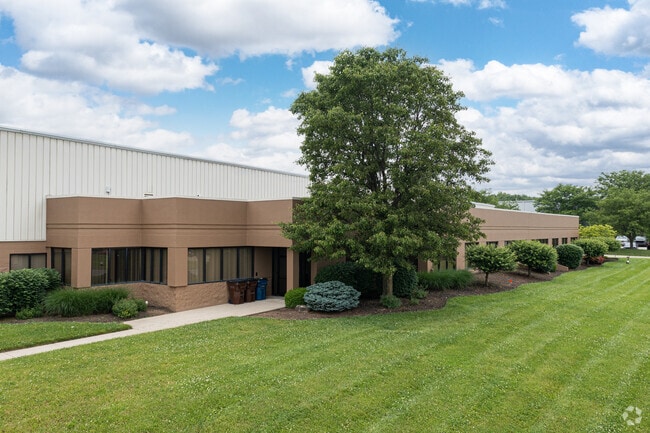


This Property Is For Sale
Current Lease Availabilities
NEARBY LISTINGS FOR SALE OR LEASE
Property Detail
119 Northeast Dr
Cincinnati, OH-KY-IN
Loveland Commerce Center
621-0016-0019
NORTHEAST DR 352.47 X 742.53 FT IRR LOT 6 LOVELAND COMMERCE
Warehouse
Hamilton
X
Ohio
39165C0220F
6
2024
9.99 AC
2024
I-71 Corridor
024324
Cincinnati/Dayton
DEMOGRAPHICS near 119 Northeast Dr
1 Mile
3 Mile
5 Mile
2024 Total Population
7,454
59,561
128,936
2029 Population
7,358
61,347
133,677
Pop Growth 2024-2029
(1.29%)
+ 3.00%
+ 3.68%
Average Age
42
40
41
2024 Total Households
2,995
23,263
49,262
HH Growth 2024-2029
(1.17%)
+ 3.07%
+ 3.70%
Median Household Inc
$99,888
$103,673
$108,271
Avg Household Size
2.40
2.50
2.60
2024 Avg HH Vehicles
2.00
2.00
2.00
Median Home Value
$286,792
$323,681
$318,254
Median Year Built
1987
1986
1987
Nearby Places
Map Layers
Map Styles
 Street
 Aerial
- Restaurants
- Banks
- Shops
- Fitness
- Groceries
PUBLIC TRANSPORTATION
AIRPORT
Cincinnati/Northern Kentucky International
DRIVE
WALK
Distance
Cincinnati/Northern Kentucky International
55 min
34.8 mi
Freight Ports
Port of Toledo
DRIVE
WALK
Distance
Port of Toledo
230 min
192.7 mi
Nearby Properties
Address
Land Use
TOTAL SIZE
Lot Size
Zoning
Address
Land Use
TOTAL SIZE
Lot Size
Zoning
232.72 AC
Address
Land Use
TOTAL SIZE
Lot Size
Zoning
232.72 AC
Address
Land Use
TOTAL SIZE
Lot Size
Zoning
274,436 SF
27.12 AC
Address
Land Use
TOTAL SIZE
Lot Size
Zoning
17,484 SF
35.55 AC
Address
Land Use
TOTAL SIZE
Lot Size
Zoning
80,767 SF
7.31 AC
Address
Land Use
TOTAL SIZE
Lot Size
Zoning
29.31 AC
DD
Address
Land Use
TOTAL SIZE
Lot Size
Zoning
47,424 SF
32.35 AC
Address
Land Use
TOTAL SIZE
Lot Size
Zoning
58.52 AC
Address
Land Use
TOTAL SIZE
Lot Size
Zoning
67,636 SF
8.74 AC
Address
Land Use
TOTAL SIZE
Lot Size
Zoning
71,866 SF
14.33 AC
Address
Land Use
TOTAL SIZE
Lot Size
Zoning
42,906 SF
23.76 AC
Address
Land Use
TOTAL SIZE
Lot Size
Zoning
140,876 SF
64.04 AC
Address
Land Use
TOTAL SIZE
Lot Size
Zoning
28.73 AC
DD
Address
Land Use
TOTAL SIZE
Lot Size
Zoning
25,339 SF
14.59 AC
Address
Land Use
TOTAL SIZE
Lot Size
Zoning
12,102 SF
8.17 AC
Address
Land Use
TOTAL SIZE
Lot Size
Zoning
211,734 SF
18.14 AC
Address
Land Use
TOTAL SIZE
Lot Size
Zoning
37,906 SF
8.94 AC
Address
Land Use
TOTAL SIZE
Lot Size
Zoning
45,435 SF
22.94 AC
Address
Land Use
TOTAL SIZE
Lot Size
Zoning
26.04 AC
DD
Address
Land Use
TOTAL SIZE
Lot Size
Zoning
19.25 AC
E
Address
Land Use
TOTAL SIZE
Lot Size
Zoning
116,775 SF
12.37 AC
Address
Land Use
TOTAL SIZE
Lot Size
Zoning
41,329 SF
22.94 AC
Address
Land Use
TOTAL SIZE
Lot Size
Zoning
2,173 SF
22 AC
E
Address
Land Use
TOTAL SIZE
Lot Size
Zoning
16.76 AC
EE
Address
Land Use
TOTAL SIZE
Lot Size
Zoning
85,759 SF
13.80 AC
Address
Land Use
TOTAL SIZE
Lot Size
Zoning
30,844 SF
15.87 AC
Address
Land Use
TOTAL SIZE
Lot Size
Zoning
11,880 SF
23.07 AC
DD
Address
Land Use
TOTAL SIZE
Lot Size
Zoning
46,424 SF
11.61 AC
Address
Land Use
TOTAL SIZE
Lot Size
Zoning
76,844 SF
18.74 AC
Address
Land Use
TOTAL SIZE
Lot Size
Zoning
132,558 SF
13.90 AC
The World's #1 Commercial Real Estate Marketplace
Connect with us
© 2026 CoStar Group
The information above has been obtained from sources believed reliable. While we do not doubt its accuracy we have not verified it and make no guarantee, warranty or representation about it. It is your responsibility to independently confirm its accuracy and completeness. Any projections, opinions, assumptions, or estimates used are for example only and do not represent the current or future performance of the property. The value of this transaction to you depends on tax and other factors which should be evaluated by your tax, financial, and legal advisors. You and your advisors should conduct a careful, independent investigation of the property to determine to your satisfaction the suitability of the property for your needs.