Property Record
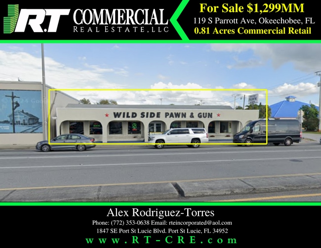
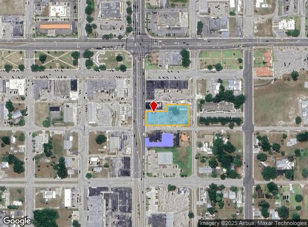
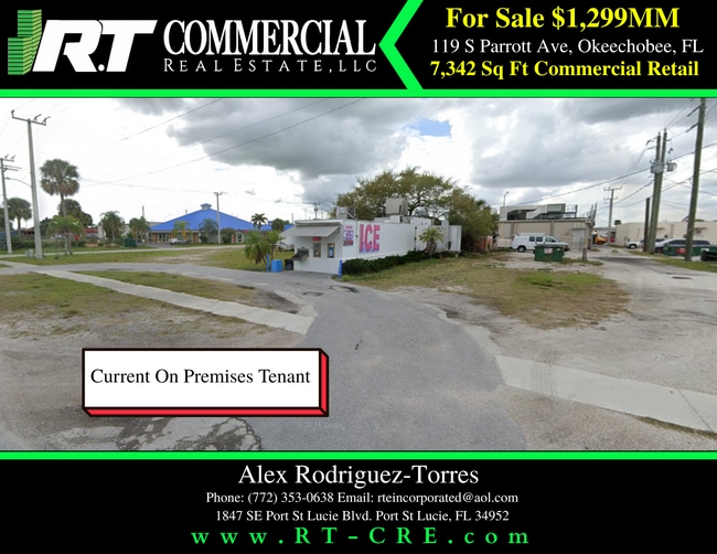
119 S Parrott Ave, Okeechobee, FL 34974
This Property Is For Sale
NEARBY LISTINGS FOR SALE OR LEASE
Property Detail
119 S Parrott Ave
Okeechobee, FL
City Of Okeechobee
R3-15-37-35-0010-01700-0080
CITY OF OKEECHOBEE (PLAT BOOK 1 PAGE 10 & PLAT BOOK 5 PAGE 5) LOTS 8 & 9 BLOCK 170 CITY OF OKEECHOBEE AND LOT 10 AND FRACTIONAL LOTS OF 11 AND 12, BLOCK 170, OKEECHOBEE, ACCORDING TO THE PLAT THEREOF RECORDED IN PLAT BOOK 5, PAGE 5, PUBLIC RECORDS OF
Storemultistory
Okeechobee
X
Florida
12043C0100D
8,9
2025
0.82 AC
2025
Florida Central South Area
910500
Other Market Areas
7,342 SF
DEMOGRAPHICS near 119 S Parrott Ave
1 Mile
3 Mile
5 Mile
2024 Total Population
4,196
20,760
27,529
2029 Population
4,460
22,172
29,249
Pop Growth 2024-2029
+ 6.29%
+ 6.80%
+ 6.25%
Average Age
42
42
42
2024 Total Households
1,599
8,053
10,341
HH Growth 2024-2029
+ 6.63%
+ 7.24%
+ 6.74%
Median Household Inc
$40,948
$44,447
$44,840
Avg Household Size
2.50
2.50
2.50
2024 Avg HH Vehicles
2.00
2.00
2.00
Median Home Value
$150,606
$132,801
$135,809
Median Year Built
1985
1985
1985
Nearby Places
- Restaurants
- Banks
- Shops
- Fitness
- Groceries
PUBLIC TRANSPORTATION
COMMUTER RAIL
Okeechobee Amtrak (Silver Star - Amtrak)
DRIVE
WALK
Distance
Okeechobee Amtrak (Silver Star - Amtrak)
2 min
13 min
0.7 mi
Freight Ports
Port of Palm Beach
DRIVE
WALK
Distance
Port of Palm Beach
85 min
59.5 mi
Nearby Properties
Address
Land Use
TOTAL SIZE
Lot Size
Zoning
Address
Land Use
TOTAL SIZE
Lot Size
Zoning
46,720 SF
108.57 AC
Address
Land Use
TOTAL SIZE
Lot Size
Zoning
80,699 SF
110.96 AC
Address
Land Use
TOTAL SIZE
Lot Size
Zoning
213,251 SF
44.36 AC
Address
Land Use
TOTAL SIZE
Lot Size
Zoning
119,085 SF
14.79 AC
Address
Land Use
TOTAL SIZE
Lot Size
Zoning
194,141 SF
30.69 AC
Address
Land Use
TOTAL SIZE
Lot Size
Zoning
105,153 SF
4.13 AC
Address
Land Use
TOTAL SIZE
Lot Size
Zoning
166,487 SF
40 AC
Address
Land Use
TOTAL SIZE
Lot Size
Zoning
95,560 SF
10.55 AC
Address
Land Use
TOTAL SIZE
Lot Size
Zoning
122,024 SF
14.12 AC
Address
Land Use
TOTAL SIZE
Lot Size
Zoning
133,382 SF
1.52 AC
Address
Land Use
TOTAL SIZE
Lot Size
Zoning
84,774 SF
7.98 AC
Address
Land Use
TOTAL SIZE
Lot Size
Zoning
90,801 SF
15.10 AC
Address
Land Use
TOTAL SIZE
Lot Size
Zoning
158,401 SF
14.89 AC
Address
Land Use
TOTAL SIZE
Lot Size
Zoning
9,262 SF
21 AC
Address
Land Use
TOTAL SIZE
Lot Size
Zoning
98,033 SF
20.56 AC
Address
Land Use
TOTAL SIZE
Lot Size
Zoning
59,251 SF
0.47 AC
Address
Land Use
TOTAL SIZE
Lot Size
Zoning
122,498 SF
10.82 AC
Address
Land Use
TOTAL SIZE
Lot Size
Zoning
84,668 SF
10.74 AC
Address
Land Use
TOTAL SIZE
Lot Size
Zoning
88,120 SF
15.30 AC
Address
Land Use
TOTAL SIZE
Lot Size
Zoning
51,715 SF
41 AC
Address
Land Use
TOTAL SIZE
Lot Size
Zoning
50,633 SF
4.22 AC
Address
Land Use
TOTAL SIZE
Lot Size
Zoning
9,231 SF
10.56 AC
Address
Land Use
TOTAL SIZE
Lot Size
Zoning
23,460 SF
8 AC
Address
Land Use
TOTAL SIZE
Lot Size
Zoning
44,801 SF
9.90 AC
Address
Land Use
TOTAL SIZE
Lot Size
Zoning
77,019 SF
7.76 AC
Address
Land Use
TOTAL SIZE
Lot Size
Zoning
58,312 SF
7.50 AC
Address
Land Use
TOTAL SIZE
Lot Size
Zoning
121,250 SF
10.31 AC
Address
Land Use
TOTAL SIZE
Lot Size
Zoning
2,887 SF
11.76 AC
Address
Land Use
TOTAL SIZE
Lot Size
Zoning
2,470 SF
258.06 AC
Address
Land Use
TOTAL SIZE
Lot Size
Zoning
2,100 SF
23.86 AC
The World's #1 Commercial Real Estate Marketplace
Connect with us
© 2025 CoStar Group
The information above has been obtained from sources believed reliable. While we do not doubt its accuracy we have not verified it and make no guarantee, warranty or representation about it. It is your responsibility to independently confirm its accuracy and completeness. Any projections, opinions, assumptions, or estimates used are for example only and do not represent the current or future performance of the property. The value of this transaction to you depends on tax and other factors which should be evaluated by your tax, financial, and legal advisors. You and your advisors should conduct a careful, independent investigation of the property to determine to your satisfaction the suitability of the property for your needs.