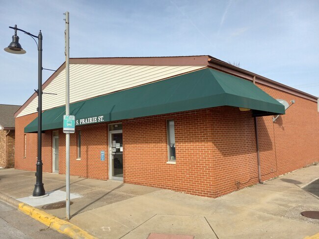
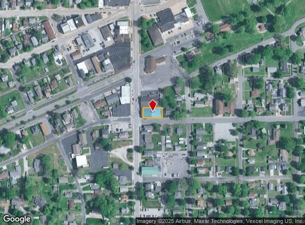
Property Record
119 S Prairie St, Bethalto, IL 62010
NEARBY LISTINGS FOR SALE OR LEASE
-
-
View all Bethalto listings for lease on LoopNet.com
Property Detail
119 S Prairie St
St. Louis
Cox Addn
St. Louis, MO-IL
COX ADD TO BETHALTO CORP LOT 20 & PT 21 62' X 120'
15-2-09-06-17-301-005
Madison
Medicalbuilding
Illinois
2024
20
2024
0.17 AC
401722
Illinois
3,658 SF
DEMOGRAPHICS near 119 S Prairie St
1 Mile
3 Mile
5 Mile
2024 Total Population
7,648
18,365
41,660
2029 Population
7,545
18,140
41,144
Pop Growth 2024-2029
(1.35%)
(1.23%)
(1.24%)
Average Age
41
42
42
2024 Total Households
3,314
7,799
17,746
HH Growth 2024-2029
(1.36%)
(1.24%)
(1.28%)
Median Household Inc
$67,324
$67,447
$63,412
Avg Household Size
2.30
2.30
2.30
2024 Avg HH Vehicles
2.00
2.00
2.00
Median Home Value
$157,834
$151,119
$132,184
Median Year Built
1973
1968
1961
Nearby Places
Map Layers
Map Styles
 Street
 Aerial
- Restaurants
- Banks
- Shops
- Fitness
- Groceries
PUBLIC TRANSPORTATION
COMMUTER RAIL
Alton Amtrak Station (Lincoln Service - Amtrak, Lincoln Service Missouri River Runner - Amtrak, Texas Eagle - Amtrak)
DRIVE
WALK
Distance
Alton Amtrak Station (Lincoln Service - Amtrak, Lincoln Service Missouri River Runner - Amtrak, Texas Eagle - Amtrak)
15 min
7.7 mi
AIRPORT
St Louis Lambert International
DRIVE
WALK
Distance
St Louis Lambert International
41 min
28.0 mi
Scott AFB/Midamerica St Louis
DRIVE
WALK
Distance
Scott AFB/Midamerica St Louis
58 min
40.8 mi
Freight Ports
Port Milwaukee
DRIVE
WALK
Distance
Port Milwaukee
400 min
351.1 mi
SALE & LEASE HISTORY
LISTING DATE
SALE/LEASE

Jun 21, 2022
For Sale
Jul 08, 2022
For Lease
Nearby Properties
Address
Land Use
TOTAL SIZE
Lot Size
Zoning
Address
Land Use
TOTAL SIZE
Lot Size
Zoning
147,365 SF
1.91 AC
Address
Land Use
TOTAL SIZE
Lot Size
Zoning
66,140 SF
9.79 AC
Address
Land Use
TOTAL SIZE
Lot Size
Zoning
62,859 SF
12 AC
Address
Land Use
TOTAL SIZE
Lot Size
Zoning
58,900 SF
2.05 AC
Address
Land Use
TOTAL SIZE
Lot Size
Zoning
20,000 SF
10.81 AC
Address
Land Use
TOTAL SIZE
Lot Size
Zoning
55,020 SF
2.85 AC
Address
Land Use
TOTAL SIZE
Lot Size
Zoning
21,200 SF
4 AC
Address
Land Use
TOTAL SIZE
Lot Size
Zoning
21,614 SF
0.62 AC
Address
Land Use
TOTAL SIZE
Lot Size
Zoning
111,616 SF
10 AC
Address
Land Use
TOTAL SIZE
Lot Size
Zoning
41,203 SF
Address
Land Use
TOTAL SIZE
Lot Size
Zoning
27,000 SF
10 AC
Address
Land Use
TOTAL SIZE
Lot Size
Zoning
8,992 SF
2 AC
Address
Land Use
TOTAL SIZE
Lot Size
Zoning
6,000 SF
5.78 AC
Address
Land Use
TOTAL SIZE
Lot Size
Zoning
24,080 SF
10.70 AC
Address
Land Use
TOTAL SIZE
Lot Size
Zoning
3,780 SF
6.63 AC
Address
Land Use
TOTAL SIZE
Lot Size
Zoning
24,148 SF
2.39 AC
Address
Land Use
TOTAL SIZE
Lot Size
Zoning
4,636 SF
0.79 AC
Address
Land Use
TOTAL SIZE
Lot Size
Zoning
3,002 SF
1.85 AC
Address
Land Use
TOTAL SIZE
Lot Size
Zoning
5,325 SF
0.69 AC
Address
Land Use
TOTAL SIZE
Lot Size
Zoning
13,809 SF
1.91 AC
Address
Land Use
TOTAL SIZE
Lot Size
Zoning
2,584 SF
1.66 AC
Address
Land Use
TOTAL SIZE
Lot Size
Zoning
10,080 SF
2.11 AC
Address
Land Use
TOTAL SIZE
Lot Size
Zoning
2,400 SF
30.26 AC
Address
Land Use
TOTAL SIZE
Lot Size
Zoning
9,450 SF
5.92 AC
Address
Land Use
TOTAL SIZE
Lot Size
Zoning
8,968 SF
3.27 AC
Address
Land Use
TOTAL SIZE
Lot Size
Zoning
24,945 SF
2.91 AC
Address
Land Use
TOTAL SIZE
Lot Size
Zoning
8,855 SF
1.66 AC
Address
Land Use
TOTAL SIZE
Lot Size
Zoning
4,020 SF
1.39 AC
Address
Land Use
TOTAL SIZE
Lot Size
Zoning
39,256 SF
6.20 AC
Address
Land Use
TOTAL SIZE
Lot Size
Zoning
31,428 SF
2.06 AC
The World's #1 Commercial Real Estate Marketplace
Connect with us
© 2026 CoStar Group
The information above has been obtained from sources believed reliable. While we do not doubt its accuracy we have not verified it and make no guarantee, warranty or representation about it. It is your responsibility to independently confirm its accuracy and completeness. Any projections, opinions, assumptions, or estimates used are for example only and do not represent the current or future performance of the property. The value of this transaction to you depends on tax and other factors which should be evaluated by your tax, financial, and legal advisors. You and your advisors should conduct a careful, independent investigation of the property to determine to your satisfaction the suitability of the property for your needs.