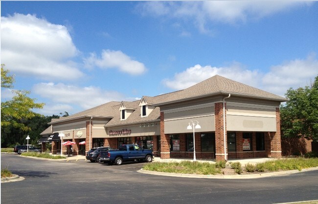
Property Record
103 W Gilmer Rd, Hawthorn Woods, IL 60047
NEARBY LISTINGS FOR SALE OR LEASE
Property Detail
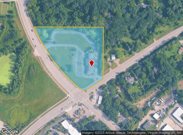
103 W Gilmer Rd
Chicago-Naperville-Elgin, IL-IN-WI
Pt Nw Ne
14-03-200-062
PT NW NE;W11.46CHS LYG NE OF CL CH26 & NW OF CL RT63(EX N281.4 & EX DOC 4012040 AS DED FOR GILMER RD) SECTION 3 TOWNSHIP 43 RANGE 10
Commercialbuilding
Lake
X
Illinois
17097C0231K
7.47 AC
2023
Central Northwest
2024
Chicago
864402
DEMOGRAPHICS near 103 W Gilmer Rd
1 Mile
3 Mile
5 Mile
2024 Total Population
3,152
33,274
114,584
2029 Population
3,151
33,024
113,705
Pop Growth 2024-2029
(0.03%)
(0.75%)
(0.77%)
Average Age
41
41
41
2024 Total Households
1,031
11,450
41,244
HH Growth 2024-2029
(0.19%)
(0.89%)
(0.83%)
Median Household Inc
$182,972
$122,729
$114,041
Avg Household Size
3.00
2.90
2.70
2024 Avg HH Vehicles
3.00
2.00
2.00
Median Home Value
$558,219
$384,760
$365,556
Median Year Built
1995
1991
1985
Nearby Places
Map Layers
Map Styles
 Street
 Aerial
- Restaurants
- Banks
- Shops
- Fitness
- Groceries
PUBLIC TRANSPORTATION
COMMUTER RAIL
Mundelein Station (North Central Service - Northeast Illinois Regional Commuter Railroad (Metra))
DRIVE
WALK
Distance
Mundelein Station (North Central Service - Northeast Illinois Regional Commuter Railroad (Metra))
10 min
3.9 mi
Vernon Hills Station (North Central Service - Northeast Illinois Regional Commuter Railroad (Metra))
DRIVE
WALK
Distance
Vernon Hills Station (North Central Service - Northeast Illinois Regional Commuter Railroad (Metra))
14 min
6.0 mi
AIRPORT
Chicago O'Hare International
DRIVE
WALK
Distance
Chicago O'Hare International
43 min
25.6 mi
Chicago Midway International
DRIVE
WALK
Distance
Chicago Midway International
65 min
44.0 mi
Nearby Properties
Address
Land Use
TOTAL SIZE
Lot Size
Zoning
Address
Land Use
TOTAL SIZE
Lot Size
Zoning
89.48 AC
Address
Land Use
TOTAL SIZE
Lot Size
Zoning
91.65 AC
Address
Land Use
TOTAL SIZE
Lot Size
Zoning
1,692 SF
27.07 AC
Address
Land Use
TOTAL SIZE
Lot Size
Zoning
35.33 AC
Address
Land Use
TOTAL SIZE
Lot Size
Zoning
22.58 AC
Address
Land Use
TOTAL SIZE
Lot Size
Zoning
340,535 SF
19.01 AC
Address
Land Use
TOTAL SIZE
Lot Size
Zoning
22.67 AC
Address
Land Use
TOTAL SIZE
Lot Size
Zoning
18.38 AC
Address
Land Use
TOTAL SIZE
Lot Size
Zoning
3.63 AC
Address
Land Use
TOTAL SIZE
Lot Size
Zoning
1,344 SF
5.54 AC
Address
Land Use
TOTAL SIZE
Lot Size
Zoning
6.59 AC
Address
Land Use
TOTAL SIZE
Lot Size
Zoning
8.48 AC
Address
Land Use
TOTAL SIZE
Lot Size
Zoning
9.35 AC
Address
Land Use
TOTAL SIZE
Lot Size
Zoning
4.63 AC
Address
Land Use
TOTAL SIZE
Lot Size
Zoning
6.54 AC
Address
Land Use
TOTAL SIZE
Lot Size
Zoning
8.13 AC
Address
Land Use
TOTAL SIZE
Lot Size
Zoning
Address
Land Use
TOTAL SIZE
Lot Size
Zoning
20.45 AC
Address
Land Use
TOTAL SIZE
Lot Size
Zoning
7.69 AC
Address
Land Use
TOTAL SIZE
Lot Size
Zoning
1.37 AC
Address
Land Use
TOTAL SIZE
Lot Size
Zoning
Address
Land Use
TOTAL SIZE
Lot Size
Zoning
6.14 AC
Address
Land Use
TOTAL SIZE
Lot Size
Zoning
4,588 SF
6.67 AC
Address
Land Use
TOTAL SIZE
Lot Size
Zoning
14.50 AC
Address
Land Use
TOTAL SIZE
Lot Size
Zoning
4.65 AC
Address
Land Use
TOTAL SIZE
Lot Size
Zoning
1.41 AC
Address
Land Use
TOTAL SIZE
Lot Size
Zoning
21.49 AC
Address
Land Use
TOTAL SIZE
Lot Size
Zoning
4.75 AC
Address
Land Use
TOTAL SIZE
Lot Size
Zoning
4.56 AC
Address
Land Use
TOTAL SIZE
Lot Size
Zoning
9.85 AC
The World's #1 Commercial Real Estate Marketplace
Connect with us
© 2025 CoStar Group
The information above has been obtained from sources believed reliable. While we do not doubt its accuracy we have not verified it and make no guarantee, warranty or representation about it. It is your responsibility to independently confirm its accuracy and completeness. Any projections, opinions, assumptions, or estimates used are for example only and do not represent the current or future performance of the property. The value of this transaction to you depends on tax and other factors which should be evaluated by your tax, financial, and legal advisors. You and your advisors should conduct a careful, independent investigation of the property to determine to your satisfaction the suitability of the property for your needs.