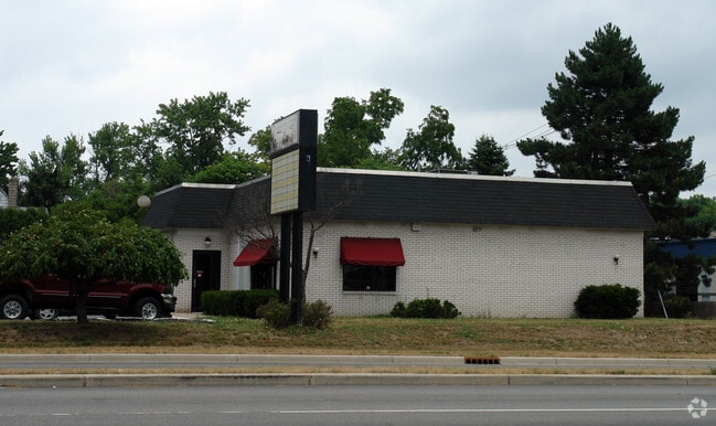
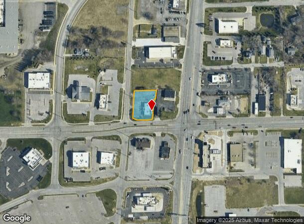
Property Record
119 W Ireland Rd, South Bend, IN 46614
Current Lease Availabilities
NEARBY LISTINGS FOR SALE OR LEASE
Property Detail
119 W Ireland Rd
South Bend-Mishawaka, IN-MI
Byers Pro
71-08-25-152-006.000-002
LOT 15 14 W 32 LOT 13 & W 50 X 148 LOT 16 BYERS PRO SW SW SEC 25 37 2E
Medicalbuilding
St Joseph
X
Indiana
18141C0194D
15,13
2023
0.65 AC
2024
Greater South Bend
003500
South Bend/Mishawaka
4,440 SF
DEMOGRAPHICS near 119 W Ireland Rd
1 Mile
3 Mile
5 Mile
2024 Total Population
3,595
46,509
134,109
2029 Population
3,546
46,483
134,681
Pop Growth 2024-2029
(1.36%)
(0.06%)
+ 0.43%
Average Age
41
38
37
2024 Total Households
1,568
18,406
52,850
HH Growth 2024-2029
(1.40%)
(0.19%)
+ 0.42%
Median Household Inc
$60,937
$52,467
$49,643
Avg Household Size
2.20
2.40
2.30
2024 Avg HH Vehicles
2.00
2.00
2.00
Median Home Value
$119,375
$134,674
$124,470
Median Year Built
1957
1959
1957
Nearby Places
- Restaurants
- Banks
- Shops
- Fitness
- Groceries
PUBLIC TRANSPORTATION
COMMUTER RAIL
DRIVE
WALK
Distance
12 min
5.4 mi
South Bend Airport Station (South Shore Line - Northern Indiana Commuter Transportation District (South Shore Line))
DRIVE
WALK
Distance
South Bend Airport Station (South Shore Line - Northern Indiana Commuter Transportation District (South Shore Line))
17 min
8.7 mi
AIRPORT
South Bend International
DRIVE
WALK
Distance
South Bend International
22 min
9.5 mi
Nearby Properties
Address
Land Use
TOTAL SIZE
Lot Size
Zoning
Address
Land Use
TOTAL SIZE
Lot Size
Zoning
270,484 SF
131 SF
Address
Land Use
TOTAL SIZE
Lot Size
Zoning
338,816 SF
33.65 AC
Address
Land Use
TOTAL SIZE
Lot Size
Zoning
283,481 SF
51.29 AC
Address
Land Use
TOTAL SIZE
Lot Size
Zoning
231,450 SF
87 SF
Address
Land Use
TOTAL SIZE
Lot Size
Zoning
194,931 SF
44 SF
Address
Land Use
TOTAL SIZE
Lot Size
Zoning
25,228 SF
68.61 AC
Address
Land Use
TOTAL SIZE
Lot Size
Zoning
544,872 SF
70.95 AC
Address
Land Use
TOTAL SIZE
Lot Size
Zoning
221,887 SF
87 SF
Address
Land Use
TOTAL SIZE
Lot Size
Zoning
353.40 AC
Address
Land Use
TOTAL SIZE
Lot Size
Zoning
174,526 SF
24.37 AC
Address
Land Use
TOTAL SIZE
Lot Size
Zoning
633,136 SF
2.59 AC
Address
Land Use
TOTAL SIZE
Lot Size
Zoning
100,368 SF
44 SF
Address
Land Use
TOTAL SIZE
Lot Size
Zoning
74,976 SF
44 SF
Address
Land Use
TOTAL SIZE
Lot Size
Zoning
94,801 SF
2.70 AC
Address
Land Use
TOTAL SIZE
Lot Size
Zoning
91,091 SF
131 SF
Address
Land Use
TOTAL SIZE
Lot Size
Zoning
136,568 SF
44 SF
Address
Land Use
TOTAL SIZE
Lot Size
Zoning
79,760 SF
13.17 AC
Address
Land Use
TOTAL SIZE
Lot Size
Zoning
79,911 SF
18.98 AC
Address
Land Use
TOTAL SIZE
Lot Size
Zoning
123,359 SF
44 SF
Address
Land Use
TOTAL SIZE
Lot Size
Zoning
87,310 SF
44 SF
Address
Land Use
TOTAL SIZE
Lot Size
Zoning
93,530 SF
8.08 AC
Address
Land Use
TOTAL SIZE
Lot Size
Zoning
58,135 SF
174 SF
Address
Land Use
TOTAL SIZE
Lot Size
Zoning
15,436 SF
174 SF
Address
Land Use
TOTAL SIZE
Lot Size
Zoning
62,834 SF
87 SF
Address
Land Use
TOTAL SIZE
Lot Size
Zoning
67,344 SF
1.24 AC
Address
Land Use
TOTAL SIZE
Lot Size
Zoning
179,328 SF
2.07 AC
Address
Land Use
TOTAL SIZE
Lot Size
Zoning
164,508 SF
61.83 AC
Address
Land Use
TOTAL SIZE
Lot Size
Zoning
158,495 SF
12.23 AC
Address
Land Use
TOTAL SIZE
Lot Size
Zoning
4,464 SF
131 SF
Address
Land Use
TOTAL SIZE
Lot Size
Zoning
52,648 SF
2.80 AC
The World's #1 Commercial Real Estate Marketplace
Connect with us
© 2025 CoStar Group
The information above has been obtained from sources believed reliable. While we do not doubt its accuracy we have not verified it and make no guarantee, warranty or representation about it. It is your responsibility to independently confirm its accuracy and completeness. Any projections, opinions, assumptions, or estimates used are for example only and do not represent the current or future performance of the property. The value of this transaction to you depends on tax and other factors which should be evaluated by your tax, financial, and legal advisors. You and your advisors should conduct a careful, independent investigation of the property to determine to your satisfaction the suitability of the property for your needs.