Property Record
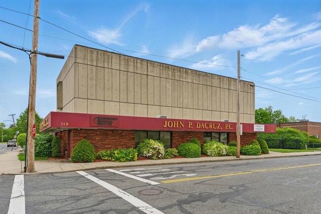
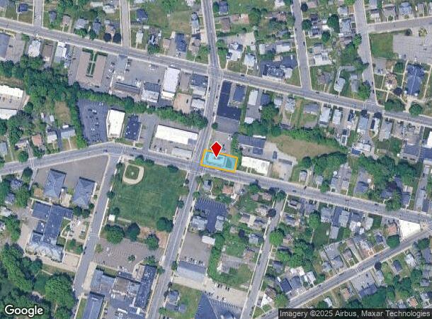
119 Winsor St, Ludlow, MA 01056
This Property Is For Sale
NEARBY LISTINGS FOR SALE OR LEASE
Property Detail
119 Winsor St
Officebuilding
Hampden
X
Massachusetts
25013C0236E
0.19 AC
2025
Hampden County
2025
Hartford
810403
Springfield, MA
4,620 SF
LUDL-141855-B000015-000002
DEMOGRAPHICS near 119 Winsor St
1 Mile
3 Mile
5 Mile
2024 Total Population
10,462
49,709
105,513
2029 Population
10,329
49,517
104,998
Pop Growth 2024-2029
(1.27%)
(0.39%)
(0.49%)
Average Age
42
42
42
2024 Total Households
4,507
19,861
41,250
HH Growth 2024-2029
(1.31%)
(0.45%)
(0.54%)
Median Household Inc
$57,598
$65,314
$67,017
Avg Household Size
2.30
2.40
2.40
2024 Avg HH Vehicles
2.00
2.00
2.00
Median Home Value
$242,277
$254,279
$243,744
Median Year Built
1953
1962
1959
Nearby Places
- Restaurants
- Banks
- Shops
- Fitness
- Groceries
PUBLIC TRANSPORTATION
COMMUTER RAIL
DRIVE
WALK
Distance
13 min
8.2 mi
AIRPORT
Bradley International
DRIVE
WALK
Distance
Bradley International
44 min
21.5 mi
Worcester Regional
DRIVE
WALK
Distance
Worcester Regional
63 min
44.9 mi
Nearby Properties
Address
Land Use
TOTAL SIZE
Lot Size
Zoning
Address
Land Use
TOTAL SIZE
Lot Size
Zoning
89,312 SF
38.72 AC
R1
Address
Land Use
TOTAL SIZE
Lot Size
Zoning
56,576 SF
62.84 AC
SR1R4
Address
Land Use
TOTAL SIZE
Lot Size
Zoning
7.41 AC
I2
Address
Land Use
TOTAL SIZE
Lot Size
Zoning
45,444 SF
13.80 AC
Address
Land Use
TOTAL SIZE
Lot Size
Zoning
131,942 SF
40.30 AC
R1
Address
Land Use
TOTAL SIZE
Lot Size
Zoning
60.25 AC
Address
Land Use
TOTAL SIZE
Lot Size
Zoning
39,776 SF
8.16 AC
R2
Address
Land Use
TOTAL SIZE
Lot Size
Zoning
94,076 SF
63.12 AC
Address
Land Use
TOTAL SIZE
Lot Size
Zoning
71,911 SF
9.19 AC
Address
Land Use
TOTAL SIZE
Lot Size
Zoning
762,340 SF
76.18 AC
SR1R2I
Address
Land Use
TOTAL SIZE
Lot Size
Zoning
99,792 SF
123.26 AC
S
Address
Land Use
TOTAL SIZE
Lot Size
Zoning
136,326 SF
65.19 AC
Address
Land Use
TOTAL SIZE
Lot Size
Zoning
15.31 AC
GB
Address
Land Use
TOTAL SIZE
Lot Size
Zoning
6.81 AC
S
Address
Land Use
TOTAL SIZE
Lot Size
Zoning
49,431 SF
6.19 AC
SR1B1
Address
Land Use
TOTAL SIZE
Lot Size
Zoning
34,732 SF
24.73 AC
R1
Address
Land Use
TOTAL SIZE
Lot Size
Zoning
3,534 SF
38.61 AC
R-3
Address
Land Use
TOTAL SIZE
Lot Size
Zoning
139,292 SF
12.54 AC
SB1I2
Address
Land Use
TOTAL SIZE
Lot Size
Zoning
34.44 AC
I
Address
Land Use
TOTAL SIZE
Lot Size
Zoning
144,253 SF
32.19 AC
SR2B1
Address
Land Use
TOTAL SIZE
Lot Size
Zoning
13.02 AC
Address
Land Use
TOTAL SIZE
Lot Size
Zoning
133,600 SF
23.27 AC
R3
Address
Land Use
TOTAL SIZE
Lot Size
Zoning
116,670 SF
13 AC
GB
Address
Land Use
TOTAL SIZE
Lot Size
Zoning
199,007 SF
50.95 AC
S
Address
Land Use
TOTAL SIZE
Lot Size
Zoning
243.13 AC
109
Address
Land Use
TOTAL SIZE
Lot Size
Zoning
34,104 SF
8 AC
R4
Address
Land Use
TOTAL SIZE
Lot Size
Zoning
95,022 SF
11.91 AC
SR1B1
Address
Land Use
TOTAL SIZE
Lot Size
Zoning
3.73 AC
I2
Address
Land Use
TOTAL SIZE
Lot Size
Zoning
3.73 AC
I2
Address
Land Use
TOTAL SIZE
Lot Size
Zoning
121,689 SF
14 AC
I2
The World's #1 Commercial Real Estate Marketplace
Connect with us
© 2025 CoStar Group
The information above has been obtained from sources believed reliable. While we do not doubt its accuracy we have not verified it and make no guarantee, warranty or representation about it. It is your responsibility to independently confirm its accuracy and completeness. Any projections, opinions, assumptions, or estimates used are for example only and do not represent the current or future performance of the property. The value of this transaction to you depends on tax and other factors which should be evaluated by your tax, financial, and legal advisors. You and your advisors should conduct a careful, independent investigation of the property to determine to your satisfaction the suitability of the property for your needs.