Property Record
1190 Main St, Wyoming, RI 02898

Save to a Folder
{{folder.Name}}
{{folder.ListingIds.length}} Properties
{{folder.ListingIds.length}} Property
Create a New Folder
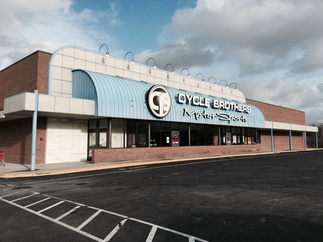
Property Detail
1190 Main St
RICH-000005B-000022
Washington
Commercialnec
Rhode Island
A Areas with a 1% annual chance of flooding and a 26% chance of flooding over the life of a 30-year mortgage.
4.80 AC
2025
Washington County
2025
Providence
050600
Providence-Warwick, RI-MA
NEARBY LISTINGS FOR SALE OR LEASE
-
-
View all Wyoming listings for lease on LoopNet.com
DEMOGRAPHICS near 1190 Main St
1 mile
3 mile
5 mile
2025 Total Population
918
5,347
11,199
2030 Population
887
5,152
10,844
Pop Growth 2025-2030
(3.38%)
(3.65%)
(3.17%)
Average Age
43
43
43
2025 Total Households
350
2,067
4,308
HH Growth 2025-2030
(4.00%)
(4.11%)
(3.64%)
Median Household Inc
$108,238
$104,647
$109,341
Avg Household Size
2.60
2.50
2.50
2025 Avg HH Vehicles
2.00
2.00
2.00
Median Home Value
$396,601
$414,945
$433,610
Median Year Built
1982
1981
1982
Nearby Places
Map Layers
Map Styles
 Street
 Aerial
Layers
 Traffic
 Biking
Places
Listings with unknown addresses are not visible on the map
- Restaurants
- Banks
- Shops
- Fitness
- Groceries
PUBLIC TRANSPORTATION
COMMUTER RAIL
Kingston Amtrak Station (Northeast Regional - Amtrak)
Drive
Walk
Distance
Kingston Amtrak Station (Northeast Regional - Amtrak)
20 min
9.0 mi
AIRPORT
Rhode Island Tf Green International
Drive
Walk
Distance
Rhode Island Tf Green International
37 min
25.7 mi
Freight Ports
Port of Davisville, RI
Drive
Walk
Distance
Port of Davisville, RI
39 min
26.0 mi
SALE & LEASE HISTORY
LISTING DATE
SALE/LEASE

Sep 25, 2016
For Lease
Oct 04, 2016
For Lease
May 13, 2026
For Lease
Aug 17, 2020
For Lease
Aug 14, 2020
For Lease
Nearby Properties
Address
Land Use
TOTAL SIZE
Lot Size
Zoning
Address
Land Use
TOTAL SIZE
Lot Size
Zoning
4.65 AC
RFR8
Address
Land Use
TOTAL SIZE
Lot Size
Zoning
40,020 SF
10.17 AC
Address
Land Use
TOTAL SIZE
Lot Size
Zoning
61,929 SF
9.35 AC
Address
Land Use
TOTAL SIZE
Lot Size
Zoning
30,944 SF
Address
Land Use
TOTAL SIZE
Lot Size
Zoning
48.30 AC
Address
Land Use
TOTAL SIZE
Lot Size
Zoning
850.10 AC
Address
Land Use
TOTAL SIZE
Lot Size
Zoning
96.91 AC
Address
Land Use
TOTAL SIZE
Lot Size
Zoning
4.78 AC
R-1
Address
Land Use
TOTAL SIZE
Lot Size
Zoning
2,852 SF
887.75 AC
Address
Land Use
TOTAL SIZE
Lot Size
Zoning
Address
Land Use
TOTAL SIZE
Lot Size
Zoning
1,735 SF
469.70 AC
Address
Land Use
TOTAL SIZE
Lot Size
Zoning
4.82 AC
RS
Address
Land Use
TOTAL SIZE
Lot Size
Zoning
43,781 SF
38.79 AC
RS
Address
Land Use
TOTAL SIZE
Lot Size
Zoning
150.99 AC
MFG
Address
Land Use
TOTAL SIZE
Lot Size
Zoning
208.60 AC
Address
Land Use
TOTAL SIZE
Lot Size
Zoning
17,854 SF
2.25 AC
Address
Land Use
TOTAL SIZE
Lot Size
Zoning
423.80 AC
Address
Land Use
TOTAL SIZE
Lot Size
Zoning
21,258 SF
9.14 AC
C
Address
Land Use
TOTAL SIZE
Lot Size
Zoning
21,809 SF
39.90 AC
RS
Address
Land Use
TOTAL SIZE
Lot Size
Zoning
13,144 SF
1.96 AC
Address
Land Use
TOTAL SIZE
Lot Size
Zoning
Address
Land Use
TOTAL SIZE
Lot Size
Zoning
12,100 SF
2.21 AC
Address
Land Use
TOTAL SIZE
Lot Size
Zoning
10,189 SF
1.65 AC
R-1
Address
Land Use
TOTAL SIZE
Lot Size
Zoning
45.01 AC
RFR8
Address
Land Use
TOTAL SIZE
Lot Size
Zoning
6,943 SF
0.96 AC
Address
Land Use
TOTAL SIZE
Lot Size
Zoning
40,400 SF
11.59 AC
Address
Land Use
TOTAL SIZE
Lot Size
Zoning
51,736 SF
4.13 AC
Address
Land Use
TOTAL SIZE
Lot Size
Zoning
198.82 AC
Address
Land Use
TOTAL SIZE
Lot Size
Zoning
6,308 SF
1.13 AC
The World's #1 Commercial Real Estate Marketplace
Connect with us
© 2026 CoStar Group
The information above has been obtained from sources believed reliable. While we do not doubt its accuracy we have not verified it and make no guarantee, warranty or representation about it. It is your responsibility to independently confirm its accuracy and completeness. Any projections, opinions, assumptions, or estimates used are for example only and do not represent the current or future performance of the property. The value of this transaction to you depends on tax and other factors which should be evaluated by your tax, financial, and legal advisors. You and your advisors should conduct a careful, independent investigation of the property to determine to your satisfaction the suitability of the property for your needs.