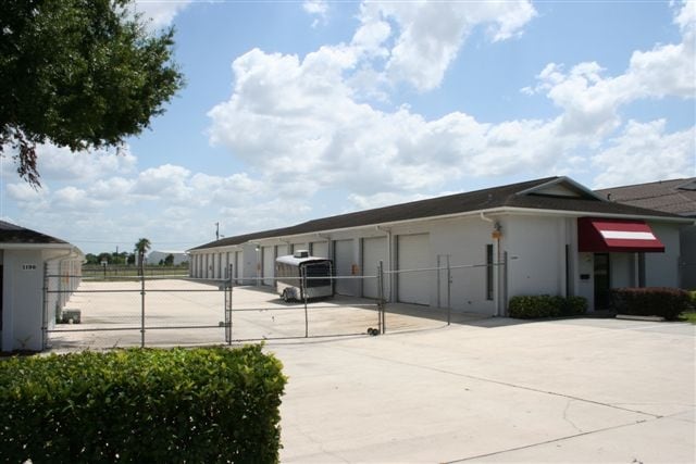
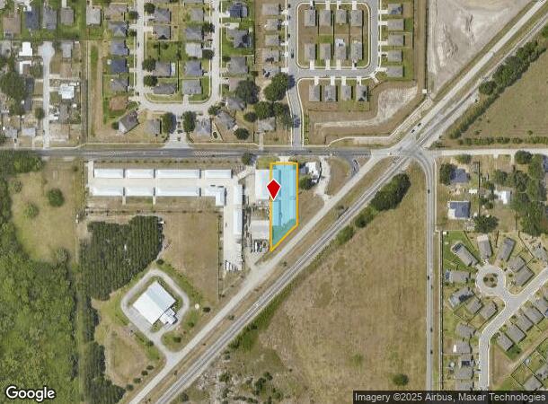
Property Record
1190 Old Lake Alfred Rd, Auburndale, FL 33823

NEARBY LISTINGS FOR SALE OR LEASE
Property Detail
1190 Old Lake Alfred Rd
Lakeland-Winter Haven, FL
Ariana Corp
25-28-02-000000-021070
THAT PART OF NE1/4 OF SE1/4 OF SEC DESC AS PART OF PORTION OF VACATED SANITARIA SUB AS REC IN PB 1 PG 14 & THAT PART OF CLOSED STS MORE PART DESC AS FOLL: BEG 10 FT N & 20 FT E OF NW COR OF LOT 5 BLK 2 RUN E 100 FT S 237.21 FT S44-45-40W 142.01 FT N
Publicstorage
Polk
X
Florida
12105C0335G
5
2024
0.66 AC
2025
Polk County
013002
Tampa/St Petersburg
9,380 SF
DEMOGRAPHICS near 1190 Old Lake Alfred Rd
1 Mile
3 Mile
5 Mile
2024 Total Population
6,034
38,564
88,854
2029 Population
7,250
46,667
107,560
Pop Growth 2024-2029
+ 20.15%
+ 21.01%
+ 21.05%
Average Age
38
40
41
2024 Total Households
2,141
14,588
34,431
HH Growth 2024-2029
+ 20.04%
+ 20.84%
+ 20.97%
Median Household Inc
$67,471
$57,204
$52,766
Avg Household Size
2.80
2.60
2.50
2024 Avg HH Vehicles
2.00
2.00
2.00
Median Home Value
$207,980
$207,370
$192,162
Median Year Built
1983
1983
1984
Nearby Places
Map Layers
Map Styles
 Street
 Aerial
- Restaurants
- Banks
- Shops
- Fitness
- Groceries
PUBLIC TRANSPORTATION
COMMUTER RAIL
Winter Haven (Silver Meteor - Amtrak, Silver Star - Amtrak)
DRIVE
WALK
Distance
Winter Haven (Silver Meteor - Amtrak, Silver Star - Amtrak)
15 min
8.1 mi
Freight Ports
Port of Tampa Bay
DRIVE
WALK
Distance
Port of Tampa Bay
67 min
45.9 mi
Nearby Properties
Address
Land Use
TOTAL SIZE
Lot Size
Zoning
Address
Land Use
TOTAL SIZE
Lot Size
Zoning
942,646 SF
91.30 AC
R3
Address
Land Use
TOTAL SIZE
Lot Size
Zoning
238,721 SF
11.66 AC
GI
Address
Land Use
TOTAL SIZE
Lot Size
Zoning
136,724 SF
4.62 AC
GI
Address
Land Use
TOTAL SIZE
Lot Size
Zoning
108,360 SF
4.23 AC
GI
Address
Land Use
TOTAL SIZE
Lot Size
Zoning
148,390 SF
10.42 AC
R1
Address
Land Use
TOTAL SIZE
Lot Size
Zoning
188,553 SF
29.12 AC
Address
Land Use
TOTAL SIZE
Lot Size
Zoning
178,899 SF
10.09 AC
GI
Address
Land Use
TOTAL SIZE
Lot Size
Zoning
241,319 SF
5.67 AC
Address
Land Use
TOTAL SIZE
Lot Size
Zoning
291,428 SF
59.34 AC
Address
Land Use
TOTAL SIZE
Lot Size
Zoning
123,540 SF
5.89 AC
Address
Land Use
TOTAL SIZE
Lot Size
Zoning
129,567 SF
11.72 AC
C3
Address
Land Use
TOTAL SIZE
Lot Size
Zoning
277,729 SF
423.34 AC
Address
Land Use
TOTAL SIZE
Lot Size
Zoning
135,247 SF
22.49 AC
C4
Address
Land Use
TOTAL SIZE
Lot Size
Zoning
91,962 SF
19.46 AC
R4
Address
Land Use
TOTAL SIZE
Lot Size
Zoning
76,664 SF
18.64 AC
RP
Address
Land Use
TOTAL SIZE
Lot Size
Zoning
191,975 SF
14.28 AC
HI
Address
Land Use
TOTAL SIZE
Lot Size
Zoning
174,108 SF
4.82 AC
Address
Land Use
TOTAL SIZE
Lot Size
Zoning
126,384 SF
4.67 AC
CH
Address
Land Use
TOTAL SIZE
Lot Size
Zoning
160,755 SF
9.94 AC
Address
Land Use
TOTAL SIZE
Lot Size
Zoning
320,765 SF
14.93 AC
GI
Address
Land Use
TOTAL SIZE
Lot Size
Zoning
268,800 SF
9.22 AC
Address
Land Use
TOTAL SIZE
Lot Size
Zoning
42,400 SF
121.06 AC
RC
Address
Land Use
TOTAL SIZE
Lot Size
Zoning
106,376 SF
18.36 AC
Address
Land Use
TOTAL SIZE
Lot Size
Zoning
243,600 SF
35.47 AC
C4
Address
Land Use
TOTAL SIZE
Lot Size
Zoning
42,668 SF
9.44 AC
R2
Address
Land Use
TOTAL SIZE
Lot Size
Zoning
169,925 SF
11.88 AC
C3
Address
Land Use
TOTAL SIZE
Lot Size
Zoning
309,124 SF
31.33 AC
XX
Address
Land Use
TOTAL SIZE
Lot Size
Zoning
231,000 SF
10.10 AC
Address
Land Use
TOTAL SIZE
Lot Size
Zoning
28,304 SF
10.28 AC
RE1
Address
Land Use
TOTAL SIZE
Lot Size
Zoning
122,260 SF
4.77 AC
The World's #1 Commercial Real Estate Marketplace
Connect with us
© 2025 CoStar Group
The information above has been obtained from sources believed reliable. While we do not doubt its accuracy we have not verified it and make no guarantee, warranty or representation about it. It is your responsibility to independently confirm its accuracy and completeness. Any projections, opinions, assumptions, or estimates used are for example only and do not represent the current or future performance of the property. The value of this transaction to you depends on tax and other factors which should be evaluated by your tax, financial, and legal advisors. You and your advisors should conduct a careful, independent investigation of the property to determine to your satisfaction the suitability of the property for your needs.