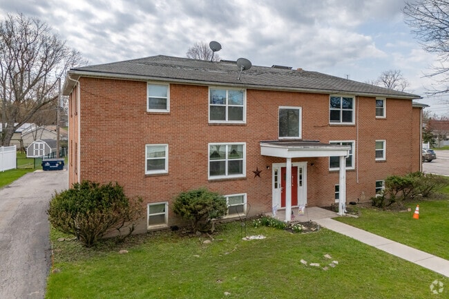
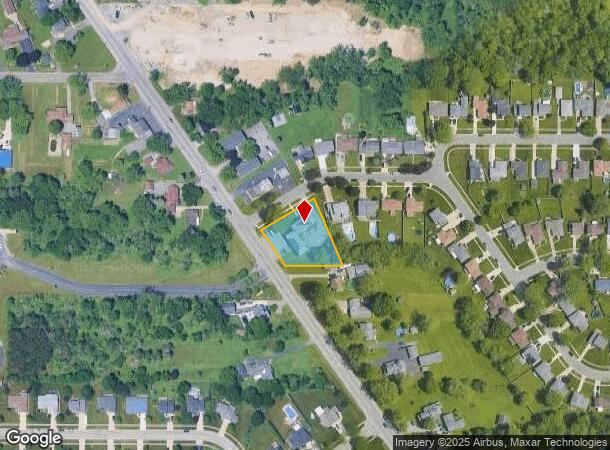
Property Record
1190 Orchard Park Rd, Buffalo, NY 14224


NEARBY LISTINGS FOR SALE OR LEASE
Property Detail
1190 Orchard Park Rd
Buffalo-Cheektowaga-Niagara Falls, NY
Buffalo Creek Reservation
146800-143-150-0003-005-000
MC-2184 SL'S-157,158 CASTLETON COURT PT-III 118.19 X 177.42(CORN LOT)
Apartment
Erie
X
New York
36029C0334H
5.000
2025
0.48 AC
2024
Cheektowaga
012002
Buffalo/Niagara Falls
7,656 SF
DEMOGRAPHICS near 1190 Orchard Park Rd
1 Mile
3 Mile
5 Mile
2024 Total Population
7,439
66,711
164,010
2029 Population
7,398
66,017
161,925
Pop Growth 2024-2029
(0.55%)
(1.04%)
(1.27%)
Average Age
44
43
43
2024 Total Households
3,070
29,557
72,010
HH Growth 2024-2029
(0.68%)
(1.10%)
(1.32%)
Median Household Inc
$87,207
$68,583
$63,142
Avg Household Size
2.40
2.20
2.20
2024 Avg HH Vehicles
2.00
2.00
2.00
Median Home Value
$209,023
$178,595
$174,318
Median Year Built
1966
1960
1959
Nearby Places
- Restaurants
- Banks
- Shops
- Fitness
- Groceries
PUBLIC TRANSPORTATION
AIRPORT
Buffalo Niagara International
DRIVE
WALK
Distance
Buffalo Niagara International
22 min
13.2 mi
Niagara Falls International
DRIVE
WALK
Distance
Niagara Falls International
42 min
27.7 mi
Freight Ports
Port of Toledo
DRIVE
WALK
Distance
Port of Toledo
353 min
300.3 mi
Nearby Properties
Address
Land Use
TOTAL SIZE
Lot Size
Zoning
Address
Land Use
TOTAL SIZE
Lot Size
Zoning
13,152 SF
496 AC
08 - GOVER
Address
Land Use
TOTAL SIZE
Lot Size
Zoning
197,584 SF
32.50 AC
B2
Address
Land Use
TOTAL SIZE
Lot Size
Zoning
48.14 AC
OP
Address
Land Use
TOTAL SIZE
Lot Size
Zoning
43,942 SF
14.34 AC
CBD
Address
Land Use
TOTAL SIZE
Lot Size
Zoning
124,112 SF
53.10 AC
05 - COMME
Address
Land Use
TOTAL SIZE
Lot Size
Zoning
149,065 SF
21.53 AC
B2
Address
Land Use
TOTAL SIZE
Lot Size
Zoning
205,680 SF
37.40 AC
11
Address
Land Use
TOTAL SIZE
Lot Size
Zoning
145,881 SF
29.40 AC
10
Address
Land Use
TOTAL SIZE
Lot Size
Zoning
107,760 SF
4.14 AC
D-E
Address
Land Use
TOTAL SIZE
Lot Size
Zoning
0.07 AC
Address
Land Use
TOTAL SIZE
Lot Size
Zoning
3,268 SF
1.68 AC
Address
Land Use
TOTAL SIZE
Lot Size
Zoning
123 AC
OP
Address
Land Use
TOTAL SIZE
Lot Size
Zoning
Address
Land Use
TOTAL SIZE
Lot Size
Zoning
165,478 SF
9.79 AC
Address
Land Use
TOTAL SIZE
Lot Size
Zoning
191,026 SF
32.60 AC
10
Address
Land Use
TOTAL SIZE
Lot Size
Zoning
72.11 AC
Address
Land Use
TOTAL SIZE
Lot Size
Zoning
34,968 SF
18.26 AC
10
Address
Land Use
TOTAL SIZE
Lot Size
Zoning
8,320 SF
22.10 AC
Address
Land Use
TOTAL SIZE
Lot Size
Zoning
149,858 SF
24.18 AC
Address
Land Use
TOTAL SIZE
Lot Size
Zoning
51,992 SF
10.20 AC
13
Address
Land Use
TOTAL SIZE
Lot Size
Zoning
3,361 SF
28.04 AC
R3
Address
Land Use
TOTAL SIZE
Lot Size
Zoning
143,400 SF
11.33 AC
B1
Address
Land Use
TOTAL SIZE
Lot Size
Zoning
98,938 SF
25.60 AC
06 - INDUS
Address
Land Use
TOTAL SIZE
Lot Size
Zoning
161,077 SF
31 AC
10
Address
Land Use
TOTAL SIZE
Lot Size
Zoning
98,517 SF
4.60 AC
SFR
Address
Land Use
TOTAL SIZE
Lot Size
Zoning
87,835 SF
21.86 AC
Address
Land Use
TOTAL SIZE
Lot Size
Zoning
134,680 SF
16.47 AC
B2
Address
Land Use
TOTAL SIZE
Lot Size
Zoning
53,511 SF
5.01 AC
B1
Address
Land Use
TOTAL SIZE
Lot Size
Zoning
18.10 AC
06 - INDUS
Address
Land Use
TOTAL SIZE
Lot Size
Zoning
82,954 SF
25.50 AC
The World's #1 Commercial Real Estate Marketplace
Connect with us
© 2025 CoStar Group
The information above has been obtained from sources believed reliable. While we do not doubt its accuracy we have not verified it and make no guarantee, warranty or representation about it. It is your responsibility to independently confirm its accuracy and completeness. Any projections, opinions, assumptions, or estimates used are for example only and do not represent the current or future performance of the property. The value of this transaction to you depends on tax and other factors which should be evaluated by your tax, financial, and legal advisors. You and your advisors should conduct a careful, independent investigation of the property to determine to your satisfaction the suitability of the property for your needs.