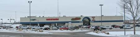
Property Record
1190 W Turnpike Ave, Bismarck, ND 58501


NEARBY LISTINGS FOR SALE OR LEASE
Property Detail
1190 W Turnpike Ave
Bismarck, ND
Prairie Hills Fourth
0820-001-100
PRAIRIE HILLS 4TH PART LOT 5 BEG ON WEST LINE 215.29'S FROM NLY MOST CORNER; THENCE S.413.18' SELY 125' SLY 67.99' SELY479.81
Supermarket
Burleigh
X
North Dakota
38015C0780E
5
2024
6 AC
2024
Downtown Bismarck
010500
Other Market Areas
55,629 SF
DEMOGRAPHICS near 1190 W Turnpike Ave
1 Mile
3 Mile
5 Mile
2024 Total Population
7,743
59,433
102,397
2029 Population
7,985
61,351
105,743
Pop Growth 2024-2029
+ 3.13%
+ 3.23%
+ 3.27%
Average Age
40
41
40
2024 Total Households
3,283
26,325
43,759
HH Growth 2024-2029
+ 3.29%
+ 3.27%
+ 3.28%
Median Household Inc
$60,223
$63,162
$67,736
Avg Household Size
2.20
2.20
2.20
2024 Avg HH Vehicles
2.00
2.00
2.00
Median Home Value
$272,875
$266,369
$260,175
Median Year Built
1983
1980
1984
Nearby Places
Map Layers
Map Styles
 Street
 Aerial
- Restaurants
- Banks
- Shops
- Fitness
- Groceries
PUBLIC TRANSPORTATION
AIRPORT
Bismarck Municipal
DRIVE
WALK
Distance
Bismarck Municipal
22 min
7.1 mi
SALE & LEASE HISTORY
LISTING DATE
SALE/LEASE

Nov 29, 2018
For Sale
Nearby Properties
Address
Land Use
TOTAL SIZE
Lot Size
Zoning
Address
Land Use
TOTAL SIZE
Lot Size
Zoning
45.23 AC
CG
Address
Land Use
TOTAL SIZE
Lot Size
Zoning
13.47 AC
PUD
Address
Land Use
TOTAL SIZE
Lot Size
Zoning
93,860 SF
1.44 AC
HM
Address
Land Use
TOTAL SIZE
Lot Size
Zoning
70,182 SF
3.83 AC
PUD
Address
Land Use
TOTAL SIZE
Lot Size
Zoning
81,092 SF
4.17 AC
HM
Address
Land Use
TOTAL SIZE
Lot Size
Zoning
7.67 AC
CG
Address
Land Use
TOTAL SIZE
Lot Size
Zoning
31,202 SF
9.05 AC
RM30
Address
Land Use
TOTAL SIZE
Lot Size
Zoning
38,467 SF
13.89 AC
CG
Address
Land Use
TOTAL SIZE
Lot Size
Zoning
65,001 SF
9.88 AC
RT
Address
Land Use
TOTAL SIZE
Lot Size
Zoning
16.12 AC
CG
Address
Land Use
TOTAL SIZE
Lot Size
Zoning
38,275 SF
10.53 AC
RM30
Address
Land Use
TOTAL SIZE
Lot Size
Zoning
13.98 AC
CG
Address
Land Use
TOTAL SIZE
Lot Size
Zoning
74,564 SF
6.67 AC
RT
Address
Land Use
TOTAL SIZE
Lot Size
Zoning
51,723 SF
1.69 AC
HM
Address
Land Use
TOTAL SIZE
Lot Size
Zoning
10.84 AC
CG
Address
Land Use
TOTAL SIZE
Lot Size
Zoning
57,580 SF
8.85 AC
CG
Address
Land Use
TOTAL SIZE
Lot Size
Zoning
3.90 AC
RM30
Address
Land Use
TOTAL SIZE
Lot Size
Zoning
8.64 AC
ETZ
Address
Land Use
TOTAL SIZE
Lot Size
Zoning
62,652 SF
2.34 AC
HM
Address
Land Use
TOTAL SIZE
Lot Size
Zoning
99,684 SF
2.33 AC
MA
Address
Land Use
TOTAL SIZE
Lot Size
Zoning
74,250 SF
5.63 AC
PUD
Address
Land Use
TOTAL SIZE
Lot Size
Zoning
15,656 SF
8.98 AC
RM30
Address
Land Use
TOTAL SIZE
Lot Size
Zoning
25.59 AC
CG
Address
Land Use
TOTAL SIZE
Lot Size
Zoning
10.58 AC
CG
Address
Land Use
TOTAL SIZE
Lot Size
Zoning
10.14 AC
CG
Address
Land Use
TOTAL SIZE
Lot Size
Zoning
7,560 SF
4.39 AC
PUD
Address
Land Use
TOTAL SIZE
Lot Size
Zoning
14.65 AC
CG
Address
Land Use
TOTAL SIZE
Lot Size
Zoning
6.86 AC
CG
Address
Land Use
TOTAL SIZE
Lot Size
Zoning
4.18 AC
RT
Address
Land Use
TOTAL SIZE
Lot Size
Zoning
88,263 SF
8.58 AC
CG
The World's #1 Commercial Real Estate Marketplace
Connect with us
© 2026 CoStar Group
The information above has been obtained from sources believed reliable. While we do not doubt its accuracy we have not verified it and make no guarantee, warranty or representation about it. It is your responsibility to independently confirm its accuracy and completeness. Any projections, opinions, assumptions, or estimates used are for example only and do not represent the current or future performance of the property. The value of this transaction to you depends on tax and other factors which should be evaluated by your tax, financial, and legal advisors. You and your advisors should conduct a careful, independent investigation of the property to determine to your satisfaction the suitability of the property for your needs.