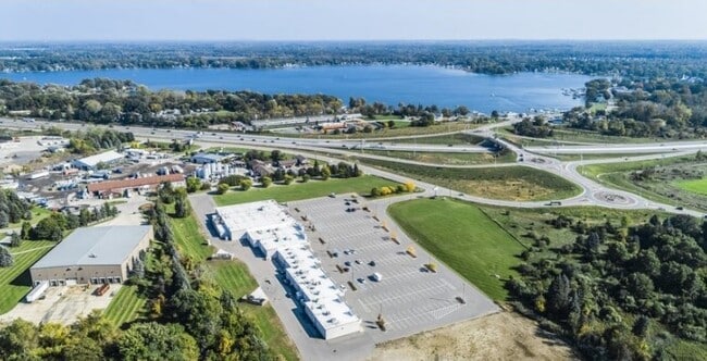
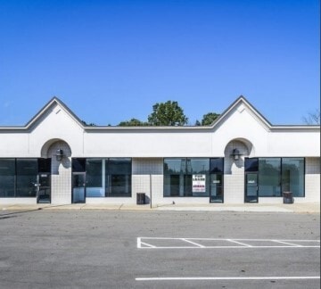
Property Record
11900 Whitmore Lake Rd, Whitmore Lake, MI 48189
NEARBY LISTINGS FOR SALE OR LEASE
-
-
View all Whitmore Lake listings for sale on LoopNet.com
Property Detail
11900 Whitmore Lake Rd
16-31-400-030
SEC 31 T1N, R6E, PART OF SE 1/4, COM SE COR; TH S87*33'16"W 4858.28 FT; TH N5*10'12"E 56.39 FT; TH NE'LY ON ARC RT LGT 510.80
Commercialnec
Livingston
X
Michigan
26161C0092E
7.16 AC
2025
Livingston County
2025
Detroit
465001
Detroit-Warren-Dearborn, MI
46,647 SF
DEMOGRAPHICS near 11900 Whitmore Lake Rd
1 Mile
3 Mile
5 Mile
2024 Total Population
3,432
14,512
34,956
2029 Population
3,496
14,699
35,581
Pop Growth 2024-2029
+ 1.86%
+ 1.29%
+ 1.79%
Average Age
40
42
43
2024 Total Households
1,327
5,799
13,552
HH Growth 2024-2029
+ 1.88%
+ 1.19%
+ 1.71%
Median Household Inc
$63,936
$81,272
$98,214
Avg Household Size
2.30
2.40
2.50
2024 Avg HH Vehicles
2.00
2.00
2.00
Median Home Value
$178,695
$300,629
$338,380
Median Year Built
1992
1989
1989
Nearby Places
- Restaurants
- Banks
- Shops
- Fitness
- Groceries
PUBLIC TRANSPORTATION
AIRPORT
Detroit Metro Wayne County
DRIVE
WALK
Distance
Detroit Metro Wayne County
36 min
38.0 mi
Freight Ports
Port of Baltimore
DRIVE
WALK
Distance
Port of Baltimore
1 min
433.8 mi
SALE & LEASE HISTORY
LISTING DATE
SALE/LEASE

Oct 30, 2019
For Sale
Oct 17, 2018
For Sale
Nov 02, 2021
For Lease
Jul 09, 2025
For Sale
Jul 09, 2025
For Sale
Nearby Properties
Address
Land Use
TOTAL SIZE
Lot Size
Zoning
Address
Land Use
TOTAL SIZE
Lot Size
Zoning
301,472 SF
72.80 AC
LI
Address
Land Use
TOTAL SIZE
Lot Size
Zoning
136,172 SF
90.76 AC
PUD-VMU-2
Address
Land Use
TOTAL SIZE
Lot Size
Zoning
301,472 SF
62.80 AC
LI
Address
Land Use
TOTAL SIZE
Lot Size
Zoning
893 SF
130.95 AC
MHP-MOBIL
Address
Land Use
TOTAL SIZE
Lot Size
Zoning
32,964 SF
11.95 AC
MR-MULTIPL
Address
Land Use
TOTAL SIZE
Lot Size
Zoning
55,885 SF
6.51 AC
VC
Address
Land Use
TOTAL SIZE
Lot Size
Zoning
10,839 SF
9.52 AC
MR-MULTIPL
Address
Land Use
TOTAL SIZE
Lot Size
Zoning
101,120 SF
12.30 AC
RM
Address
Land Use
TOTAL SIZE
Lot Size
Zoning
1,970 SF
37.72 AC
MHP
Address
Land Use
TOTAL SIZE
Lot Size
Zoning
103,900 SF
26.88 AC
GI
Address
Land Use
TOTAL SIZE
Lot Size
Zoning
62,548 SF
4.28 AC
GC-GEN COM
Address
Land Use
TOTAL SIZE
Lot Size
Zoning
50 AC
MHP
Address
Land Use
TOTAL SIZE
Lot Size
Zoning
133.34 AC
PUD-VMU-2
Address
Land Use
TOTAL SIZE
Lot Size
Zoning
17.83 AC
HC
Address
Land Use
TOTAL SIZE
Lot Size
Zoning
128 AC
R3
Address
Land Use
TOTAL SIZE
Lot Size
Zoning
19,390 SF
2.44 AC
VC
Address
Land Use
TOTAL SIZE
Lot Size
Zoning
73,711 SF
6.77 AC
LI
Address
Land Use
TOTAL SIZE
Lot Size
Zoning
52,800 SF
8.10 AC
LB
Address
Land Use
TOTAL SIZE
Lot Size
Zoning
47,088 SF
7.72 AC
RM
Address
Land Use
TOTAL SIZE
Lot Size
Zoning
105,868 SF
37.75 AC
GI
Address
Land Use
TOTAL SIZE
Lot Size
Zoning
52,100 SF
10.36 AC
GI
Address
Land Use
TOTAL SIZE
Lot Size
Zoning
29,928 SF
7 AC
VC
Address
Land Use
TOTAL SIZE
Lot Size
Zoning
24,500 SF
12.15 AC
GI
Address
Land Use
TOTAL SIZE
Lot Size
Zoning
12,942 SF
1.52 AC
VC
Address
Land Use
TOTAL SIZE
Lot Size
Zoning
3,800 SF
5.53 AC
GC-GEN COM
Address
Land Use
TOTAL SIZE
Lot Size
Zoning
45,800 SF
3.23 AC
LI
Address
Land Use
TOTAL SIZE
Lot Size
Zoning
26,392 SF
13.15 AC
GI
Address
Land Use
TOTAL SIZE
Lot Size
Zoning
29,636 SF
3.51 AC
R1
Address
Land Use
TOTAL SIZE
Lot Size
Zoning
41,228 SF
3.90 AC
LI
The World's #1 Commercial Real Estate Marketplace
Connect with us
© 2025 CoStar Group
The information above has been obtained from sources believed reliable. While we do not doubt its accuracy we have not verified it and make no guarantee, warranty or representation about it. It is your responsibility to independently confirm its accuracy and completeness. Any projections, opinions, assumptions, or estimates used are for example only and do not represent the current or future performance of the property. The value of this transaction to you depends on tax and other factors which should be evaluated by your tax, financial, and legal advisors. You and your advisors should conduct a careful, independent investigation of the property to determine to your satisfaction the suitability of the property for your needs.