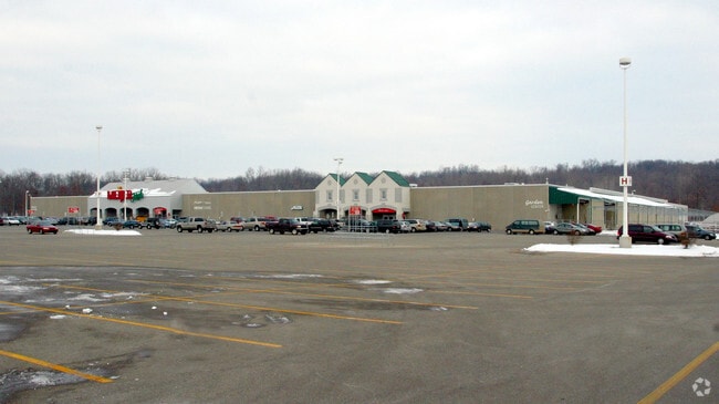
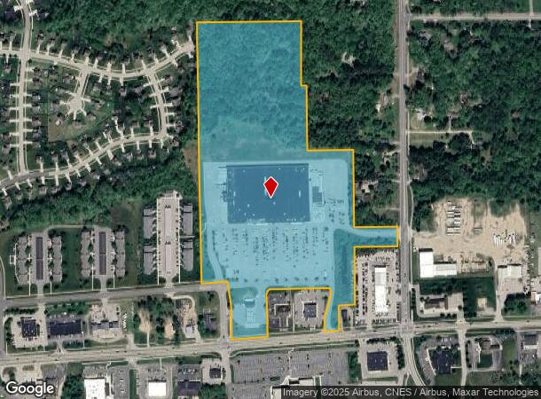
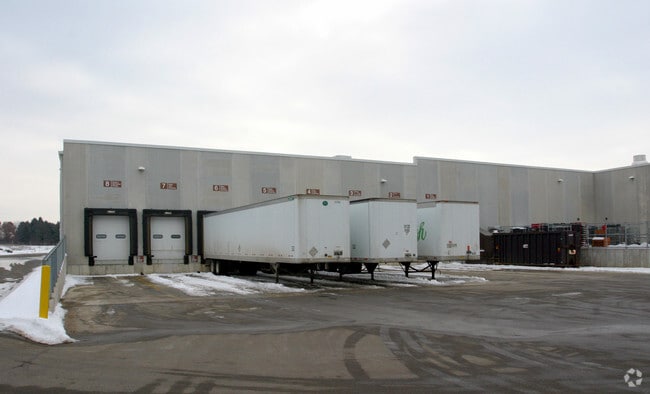
Property Record
11901 Fulton St E, Lowell, MI 49331
Current Lease Availabilities
NEARBY LISTINGS FOR SALE OR LEASE
Property Detail
11901 Fulton St E
41-20-04-426-047
412004426047 PART OF SE 1/4 COM 660.0 FT N 89D 05M 17S W ALONG E&W 1/4 LINE FROM E 1/4 COR TH N 89D 05M 17S W ALONG E&W 1/4
Storemultistory
Kent
X
Michigan
26081C0486D
37.61 AC
2024
Ada/Lowell
2025
West Michigan
012003
Grand Rapids-Wyoming-Kentwood, MI
196,043 SF
DEMOGRAPHICS near 11901 Fulton St E
1 Mile
3 Mile
5 Mile
2024 Total Population
3,489
12,147
19,185
2029 Population
3,557
12,361
19,498
Pop Growth 2024-2029
+ 1.95%
+ 1.76%
+ 1.63%
Average Age
38
39
40
2024 Total Households
1,356
4,592
7,035
HH Growth 2024-2029
+ 1.92%
+ 1.76%
+ 1.63%
Median Household Inc
$76,407
$84,426
$92,172
Avg Household Size
2.50
2.60
2.70
2024 Avg HH Vehicles
2.00
2.00
2.00
Median Home Value
$245,833
$267,952
$291,977
Median Year Built
1988
1981
1982
Nearby Places
Map Layers
Map Styles
 Street
 Aerial
- Restaurants
- Banks
- Shops
- Fitness
- Groceries
PUBLIC TRANSPORTATION
AIRPORT
Gerald R Ford International
DRIVE
WALK
Distance
Gerald R Ford International
30 min
19.5 mi
Freight Ports
Port Milwaukee
DRIVE
WALK
Distance
Port Milwaukee
328 min
279.6 mi
Nearby Properties
Address
Land Use
TOTAL SIZE
Lot Size
Zoning
Address
Land Use
TOTAL SIZE
Lot Size
Zoning
Address
Land Use
TOTAL SIZE
Lot Size
Zoning
460,941 SF
20.90 AC
I
Address
Land Use
TOTAL SIZE
Lot Size
Zoning
7.41 AC
COMM
Address
Land Use
TOTAL SIZE
Lot Size
Zoning
177,214 SF
16.91 AC
I
Address
Land Use
TOTAL SIZE
Lot Size
Zoning
48,566 SF
3.04 AC
PF
Address
Land Use
TOTAL SIZE
Lot Size
Zoning
2,728 SF
87 SF
MH
Address
Land Use
TOTAL SIZE
Lot Size
Zoning
33,491 SF
Address
Land Use
TOTAL SIZE
Lot Size
Zoning
26,565 SF
Address
Land Use
TOTAL SIZE
Lot Size
Zoning
80,425 SF
13.50 AC
R3
Address
Land Use
TOTAL SIZE
Lot Size
Zoning
56,362 SF
5.03 AC
PUD
Address
Land Use
TOTAL SIZE
Lot Size
Zoning
55,882 SF
5.57 AC
PUD
Address
Land Use
TOTAL SIZE
Lot Size
Zoning
59,440 SF
R-A
Address
Land Use
TOTAL SIZE
Lot Size
Zoning
171,588 SF
19.72 AC
I
Address
Land Use
TOTAL SIZE
Lot Size
Zoning
10.14 AC
Address
Land Use
TOTAL SIZE
Lot Size
Zoning
30,408 SF
2.11 AC
R3
Address
Land Use
TOTAL SIZE
Lot Size
Zoning
34,123 SF
3.10 AC
C3
Address
Land Use
TOTAL SIZE
Lot Size
Zoning
35,889 SF
1.48 AC
I
Address
Land Use
TOTAL SIZE
Lot Size
Zoning
21.45 AC
R2
Address
Land Use
TOTAL SIZE
Lot Size
Zoning
36,440 SF
44 SF
R3
Address
Land Use
TOTAL SIZE
Lot Size
Zoning
16,213 SF
3.73 AC
COMM
Address
Land Use
TOTAL SIZE
Lot Size
Zoning
12.93 AC
Address
Land Use
TOTAL SIZE
Lot Size
Zoning
68.92 AC
AP
Address
Land Use
TOTAL SIZE
Lot Size
Zoning
14,621 SF
2.78 AC
C3
Address
Land Use
TOTAL SIZE
Lot Size
Zoning
14,104 SF
2.33 AC
I
Address
Land Use
TOTAL SIZE
Lot Size
Zoning
4,500 SF
2.55 AC
C2
Address
Land Use
TOTAL SIZE
Lot Size
Zoning
43,120 SF
Address
Land Use
TOTAL SIZE
Lot Size
Zoning
35,616 SF
3.79 AC
R3
Address
Land Use
TOTAL SIZE
Lot Size
Zoning
1,326 SF
3.11 AC
I
Address
Land Use
TOTAL SIZE
Lot Size
Zoning
34,287 SF
0.71 AC
MU
The World's #1 Commercial Real Estate Marketplace
Connect with us
© 2026 CoStar Group
The information above has been obtained from sources believed reliable. While we do not doubt its accuracy we have not verified it and make no guarantee, warranty or representation about it. It is your responsibility to independently confirm its accuracy and completeness. Any projections, opinions, assumptions, or estimates used are for example only and do not represent the current or future performance of the property. The value of this transaction to you depends on tax and other factors which should be evaluated by your tax, financial, and legal advisors. You and your advisors should conduct a careful, independent investigation of the property to determine to your satisfaction the suitability of the property for your needs.