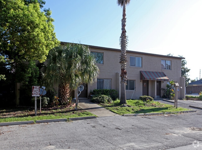
Property Record
11901 Pasteur Dr, Orlando, FL 32826


Save to a Folder
{{folder.Name}}
{{folder.ListingIds.length}} Properties
{{folder.ListingIds.length}} Property
Create a New Folder
Property Detail
11901 Pasteur Dr
10-2231-9652-01-050
UNIVERSITY HYLANDS Z/137 LOTS 5 THROUGH 9 BLK A
Apartmenthouse5plusunits
ORANGE
R-3
Florida
B and X Area of moderate flood hazard, usually the area between the limits of the 100-year and 500-year floods.
5-9
2025
1.22 AC
2026
University
016510
Orlando
22,790 SF
Orlando-Kissimmee-Sanford, FL
NEARBY LISTINGS FOR SALE OR LEASE
-
-
View all Orlando listings for sale on LoopNet.com
DEMOGRAPHICS near 11901 Pasteur Dr
1 mile
3 mile
5 mile
2025 Total Population
18,661
111,125
248,899
2030 Population
20,216
119,592
267,673
Pop Growth 2025-2030
+ 8.33%
+ 7.62%
+ 7.54%
Average Age
24
33
36
2025 Total Households
4,633
35,273
84,695
HH Growth 2025-2030
+ 11.29%
+ 8.68%
+ 8.17%
Median Household Inc
$19,764
$65,440
$75,824
Avg Household Size
1.90
2.50
2.60
2025 Avg HH Vehicles
2.00
2.00
2.00
Median Home Value
$305,172
$361,444
$382,633
Median Year Built
1998
1994
1994
Nearby Places
Map Layers
Map Styles
 Street
 Aerial
Layers
 Traffic
 Biking
Places
Listings with unknown addresses are not visible on the map
- Restaurants
- Banks
- Shops
- Fitness
- Groceries
PUBLIC TRANSPORTATION
AIRPORT
Orlando Sanford International
Drive
Walk
Distance
Orlando Sanford International
26 min
16.8 mi
Orlando International
Drive
Walk
Distance
Orlando International
28 min
17.7 mi
Freight Ports
Port Canaveral
Drive
Walk
Distance
Port Canaveral
57 min
42.9 mi
Nearby Properties
Address
Land Use
TOTAL SIZE
Lot Size
Zoning
Address
Land Use
TOTAL SIZE
Lot Size
Zoning
8,247,372 SF
1,194.20 AC
R-3
Address
Land Use
TOTAL SIZE
Lot Size
Zoning
1,198,236 SF
0.47 AC
P-D
Address
Land Use
TOTAL SIZE
Lot Size
Zoning
622,758 SF
P-D
Address
Land Use
TOTAL SIZE
Lot Size
Zoning
499,830 SF
24.65 AC
R-3
Address
Land Use
TOTAL SIZE
Lot Size
Zoning
745,346 SF
9.94 AC
P-D
Address
Land Use
TOTAL SIZE
Lot Size
Zoning
447,816 SF
37.44 AC
P-D
Address
Land Use
TOTAL SIZE
Lot Size
Zoning
538,816 SF
6.25 AC
P-D
Address
Land Use
TOTAL SIZE
Lot Size
Zoning
451,952 SF
21.37 AC
P-D
Address
Land Use
TOTAL SIZE
Lot Size
Zoning
605,303 SF
39.84 AC
P-D
Address
Land Use
TOTAL SIZE
Lot Size
Zoning
523,131 SF
3.82 AC
P-D
Address
Land Use
TOTAL SIZE
Lot Size
Zoning
358,221 SF
40.57 AC
IND-2/IND-
Address
Land Use
TOTAL SIZE
Lot Size
Zoning
517,774 SF
U-ORG-P-D
Address
Land Use
TOTAL SIZE
Lot Size
Zoning
7,384 SF
16.66 AC
Address
Land Use
TOTAL SIZE
Lot Size
Zoning
499,133 SF
22.04 AC
P-D
Address
Land Use
TOTAL SIZE
Lot Size
Zoning
552,060 SF
6.97 AC
P-D
Address
Land Use
TOTAL SIZE
Lot Size
Zoning
358,356 SF
19.91 AC
P-D
Address
Land Use
TOTAL SIZE
Lot Size
Zoning
3.66 AC
Address
Land Use
TOTAL SIZE
Lot Size
Zoning
599,187 SF
5.16 AC
P-D
Address
Land Use
TOTAL SIZE
Lot Size
Zoning
364,015 SF
39.43 AC
R-3
Address
Land Use
TOTAL SIZE
Lot Size
Zoning
573,835 SF
5.27 AC
P-D
Address
Land Use
TOTAL SIZE
Lot Size
Zoning
280,279 SF
31.65 AC
A1
Address
Land Use
TOTAL SIZE
Lot Size
Zoning
304,529 SF
19.98 AC
P-D
Address
Land Use
TOTAL SIZE
Lot Size
Zoning
411,516 SF
1.18 AC
P-D
Address
Land Use
TOTAL SIZE
Lot Size
Zoning
15.52 AC
Address
Land Use
TOTAL SIZE
Lot Size
Zoning
349,075 SF
19.95 AC
P-D
Address
Land Use
TOTAL SIZE
Lot Size
Zoning
380,024 SF
P-D
Address
Land Use
TOTAL SIZE
Lot Size
Zoning
255,139 SF
P-D
Address
Land Use
TOTAL SIZE
Lot Size
Zoning
3,406 SF
29.43 AC
PUD
Address
Land Use
TOTAL SIZE
Lot Size
Zoning
1,386 SF
19.84 AC
PUD
Address
Land Use
TOTAL SIZE
Lot Size
Zoning
370,136 SF
15.43 AC
P-D
The World's #1 Commercial Real Estate Marketplace
Connect with us
© 2026 CoStar Group
The information above has been obtained from sources believed reliable. While we do not doubt its accuracy we have not verified it and make no guarantee, warranty or representation about it. It is your responsibility to independently confirm its accuracy and completeness. Any projections, opinions, assumptions, or estimates used are for example only and do not represent the current or future performance of the property. The value of this transaction to you depends on tax and other factors which should be evaluated by your tax, financial, and legal advisors. You and your advisors should conduct a careful, independent investigation of the property to determine to your satisfaction the suitability of the property for your needs.