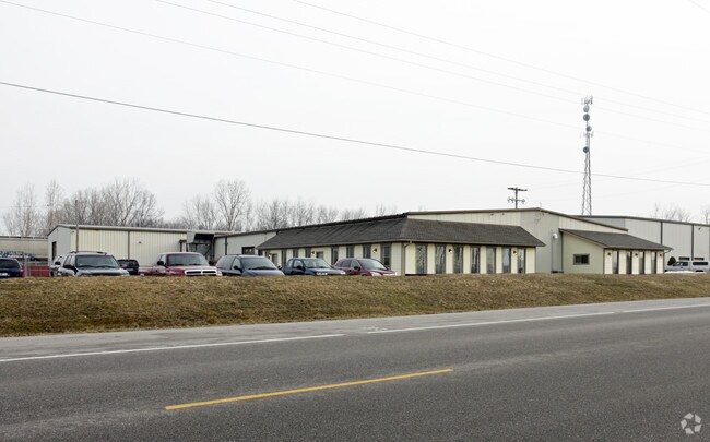
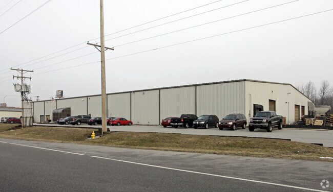
Property Record
11903 Dawkins Rd E, New Haven, IN 46774
NEARBY LISTINGS FOR SALE OR LEASE
Property Detail
11903 Dawkins Rd E
02-14-07-254-003.000-047
E 315.38 S OF RR & N OF SR 14 & TRI SPC BTW BOTH RR SW1/4 NE1/4 EX W PT S OF RR & EX TRACTS SEC 7
Warehouse
Allen
X
Indiana
18003C0330G
1.27 AC
2023
Outlying Allen County
2024
Fort Wayne
011100
Fort Wayne, IN
15,076 SF
DEMOGRAPHICS near 11903 Dawkins Rd E
1 Mile
3 Mile
5 Mile
2024 Total Population
1,291
14,703
43,648
2029 Population
1,348
15,261
45,134
Pop Growth 2024-2029
+ 4.42%
+ 3.80%
+ 3.40%
Average Age
41
40
40
2024 Total Households
547
5,952
17,366
HH Growth 2024-2029
+ 4.57%
+ 3.85%
+ 3.47%
Median Household Inc
$54,175
$59,705
$65,557
Avg Household Size
2.40
2.40
2.50
2024 Avg HH Vehicles
2.00
2.00
2.00
Median Home Value
$146,380
$154,324
$160,805
Median Year Built
1962
1972
1975
Nearby Places
Map Layers
Map Styles
 Street
 Aerial
- Restaurants
- Banks
- Shops
- Fitness
- Groceries
PUBLIC TRANSPORTATION
AIRPORT
Fort Wayne International
DRIVE
WALK
Distance
Fort Wayne International
31 min
19.6 mi
Freight Ports
Port of Toledo
DRIVE
WALK
Distance
Port of Toledo
126 min
98.4 mi
Nearby Properties
Address
Land Use
TOTAL SIZE
Lot Size
Zoning
Address
Land Use
TOTAL SIZE
Lot Size
Zoning
23,326 SF
15.27 AC
Address
Land Use
TOTAL SIZE
Lot Size
Zoning
183,230 SF
34.24 AC
Address
Land Use
TOTAL SIZE
Lot Size
Zoning
126,495 SF
9.28 AC
Address
Land Use
TOTAL SIZE
Lot Size
Zoning
249,130 SF
46.21 AC
Address
Land Use
TOTAL SIZE
Lot Size
Zoning
145,580 SF
8.15 AC
Address
Land Use
TOTAL SIZE
Lot Size
Zoning
97,329 SF
34.53 AC
Address
Land Use
TOTAL SIZE
Lot Size
Zoning
106,164 SF
10.34 AC
Address
Land Use
TOTAL SIZE
Lot Size
Zoning
465,944 SF
27.48 AC
Address
Land Use
TOTAL SIZE
Lot Size
Zoning
68,547 SF
11.50 AC
Address
Land Use
TOTAL SIZE
Lot Size
Zoning
67,800 SF
6.12 AC
Address
Land Use
TOTAL SIZE
Lot Size
Zoning
68,220 SF
9.67 AC
Address
Land Use
TOTAL SIZE
Lot Size
Zoning
39,300 SF
4.44 AC
Address
Land Use
TOTAL SIZE
Lot Size
Zoning
48,360 SF
15 AC
Address
Land Use
TOTAL SIZE
Lot Size
Zoning
33,472 SF
3.51 AC
Address
Land Use
TOTAL SIZE
Lot Size
Zoning
58,588 SF
4.58 AC
Address
Land Use
TOTAL SIZE
Lot Size
Zoning
14,548 SF
10 AC
Address
Land Use
TOTAL SIZE
Lot Size
Zoning
41,607 SF
2.26 AC
Address
Land Use
TOTAL SIZE
Lot Size
Zoning
45,472 SF
4.51 AC
Address
Land Use
TOTAL SIZE
Lot Size
Zoning
29,276 SF
81.73 AC
Address
Land Use
TOTAL SIZE
Lot Size
Zoning
43,163 SF
10 AC
Address
Land Use
TOTAL SIZE
Lot Size
Zoning
545,008 SF
77.68 AC
Address
Land Use
TOTAL SIZE
Lot Size
Zoning
40,321 SF
5.87 AC
Address
Land Use
TOTAL SIZE
Lot Size
Zoning
47,068 SF
4.36 AC
Address
Land Use
TOTAL SIZE
Lot Size
Zoning
293,241 SF
17.83 AC
Address
Land Use
TOTAL SIZE
Lot Size
Zoning
106,569 SF
7.65 AC
Address
Land Use
TOTAL SIZE
Lot Size
Zoning
177,900 SF
8.82 AC
Address
Land Use
TOTAL SIZE
Lot Size
Zoning
70,331 SF
6.43 AC
Address
Land Use
TOTAL SIZE
Lot Size
Zoning
94,903 SF
9.39 AC
Address
Land Use
TOTAL SIZE
Lot Size
Zoning
1,404 SF
7.25 AC
Address
Land Use
TOTAL SIZE
Lot Size
Zoning
364,564 SF
141.51 AC
The World's #1 Commercial Real Estate Marketplace
Connect with us
© 2025 CoStar Group
The information above has been obtained from sources believed reliable. While we do not doubt its accuracy we have not verified it and make no guarantee, warranty or representation about it. It is your responsibility to independently confirm its accuracy and completeness. Any projections, opinions, assumptions, or estimates used are for example only and do not represent the current or future performance of the property. The value of this transaction to you depends on tax and other factors which should be evaluated by your tax, financial, and legal advisors. You and your advisors should conduct a careful, independent investigation of the property to determine to your satisfaction the suitability of the property for your needs.