Property Record
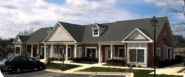
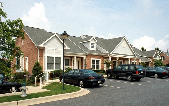
11908A Darnestown Rd, Gaithersburg, MD 20878
NEARBY LISTINGS FOR SALE OR LEASE
Property Detail
11908A Darnestown Rd
06-03146575
Quince Orchard Medl Pk Ph 1
Officecondo
QUINCE ORCHARD MEDL PK PH 1
X
Montgomery
51059C0075E
Maryland
2024
0.09 AC
2025
Outlying Montgmery Cnty W
700616
Washington, DC
976 SF
Washington-Arlington-Alexandria, DC-VA-MD-WV
DEMOGRAPHICS near 11908A Darnestown Rd
1 Mile
3 Mile
5 Mile
2024 Total Population
15,418
88,944
248,533
2029 Population
15,222
88,088
245,647
Pop Growth 2024-2029
(1.27%)
(0.96%)
(1.16%)
Average Age
42
40
39
2024 Total Households
5,803
32,645
89,276
HH Growth 2024-2029
(1.43%)
(1.03%)
(1.25%)
Median Household Inc
$162,877
$119,891
$110,278
Avg Household Size
2.60
2.70
2.70
2024 Avg HH Vehicles
2.00
2.00
2.00
Median Home Value
$723,272
$663,170
$561,661
Median Year Built
1993
1988
1987
Nearby Places
- Restaurants
- Banks
- Shops
- Fitness
- Groceries
PUBLIC TRANSPORTATION
COMMUTER RAIL
Metropolitan Grove (BRUNSWICK - WASHINGTON - Maryland Area Regional Commuter Trains (The MARC), Brunswick Line - Maryland Area Regional Commuter Trains (The MARC))
DRIVE
WALK
Distance
Metropolitan Grove (BRUNSWICK - WASHINGTON - Maryland Area Regional Commuter Trains (The MARC), Brunswick Line - Maryland Area Regional Commuter Trains (The MARC))
10 min
4.4 mi
Gaithersburg Marc Eb (BRUNSWICK - WASHINGTON - Maryland Transit Administration)
DRIVE
WALK
Distance
Gaithersburg Marc Eb (BRUNSWICK - WASHINGTON - Maryland Transit Administration)
9 min
5.3 mi
AIRPORT
Ronald Reagan Washington Ntl
DRIVE
WALK
Distance
Ronald Reagan Washington Ntl
45 min
25.5 mi
Washington Dulles International
DRIVE
WALK
Distance
Washington Dulles International
51 min
31.8 mi
Freight Ports
Port of Baltimore
DRIVE
WALK
Distance
Port of Baltimore
61 min
45.6 mi
Nearby Properties
Address
Land Use
TOTAL SIZE
Lot Size
Zoning
Address
Land Use
TOTAL SIZE
Lot Size
Zoning
849,305 SF
30.78 AC
MXD
Address
Land Use
TOTAL SIZE
Lot Size
Zoning
635,057 SF
28.09 AC
CRT0.
Address
Land Use
TOTAL SIZE
Lot Size
Zoning
713,627 SF
38.49 AC
LSC1.
Address
Land Use
TOTAL SIZE
Lot Size
Zoning
668,337 SF
10.39 AC
LSC1.
Address
Land Use
TOTAL SIZE
Lot Size
Zoning
290,912 SF
9.55 AC
LSC1.
Address
Land Use
TOTAL SIZE
Lot Size
Zoning
533,012 SF
18.08 AC
LSC1.
Address
Land Use
TOTAL SIZE
Lot Size
Zoning
488,864 SF
18.17 AC
CRT0.
Address
Land Use
TOTAL SIZE
Lot Size
Zoning
693,823 SF
5.30 AC
CR2.0
Address
Land Use
TOTAL SIZE
Lot Size
Zoning
461,295 SF
45.71 AC
LSC2.
Address
Land Use
TOTAL SIZE
Lot Size
Zoning
450,000 SF
8.53 AC
MXD
Address
Land Use
TOTAL SIZE
Lot Size
Zoning
298,300 SF
7.69 AC
CR1.0
Address
Land Use
TOTAL SIZE
Lot Size
Zoning
434,440 SF
5.09 AC
CR1.5
Address
Land Use
TOTAL SIZE
Lot Size
Zoning
24.08 AC
CRT0.
Address
Land Use
TOTAL SIZE
Lot Size
Zoning
363,750 SF
21.16 AC
R60
Address
Land Use
TOTAL SIZE
Lot Size
Zoning
370,422 SF
13.87 AC
CRT1.
Address
Land Use
TOTAL SIZE
Lot Size
Zoning
2,556 SF
555.47 AC
R200
Address
Land Use
TOTAL SIZE
Lot Size
Zoning
302,484 SF
4.99 AC
MXD
Address
Land Use
TOTAL SIZE
Lot Size
Zoning
85,381 SF
5.86 AC
MXD
Address
Land Use
TOTAL SIZE
Lot Size
Zoning
315,000 SF
4.70 AC
CR1.5
Address
Land Use
TOTAL SIZE
Lot Size
Zoning
373,116 SF
51.42 AC
I3
Address
Land Use
TOTAL SIZE
Lot Size
Zoning
1.64 AC
MXD
Address
Land Use
TOTAL SIZE
Lot Size
Zoning
170,689 SF
9.98 AC
LSC1.
Address
Land Use
TOTAL SIZE
Lot Size
Zoning
385,641 SF
2.65 AC
MXD
Address
Land Use
TOTAL SIZE
Lot Size
Zoning
279,442 SF
9.78 AC
CRT1.
Address
Land Use
TOTAL SIZE
Lot Size
Zoning
23.74 AC
CRT0.
Address
Land Use
TOTAL SIZE
Lot Size
Zoning
17.64 AC
MXD
Address
Land Use
TOTAL SIZE
Lot Size
Zoning
427,670 SF
18.36 AC
R20
Address
Land Use
TOTAL SIZE
Lot Size
Zoning
240,000 SF
1.77 AC
MXD
Address
Land Use
TOTAL SIZE
Lot Size
Zoning
462,892 SF
23.84 AC
MXD
Address
Land Use
TOTAL SIZE
Lot Size
Zoning
147,135 SF
8.16 AC
I3
The World's #1 Commercial Real Estate Marketplace
Connect with us
© 2025 CoStar Group
The information above has been obtained from sources believed reliable. While we do not doubt its accuracy we have not verified it and make no guarantee, warranty or representation about it. It is your responsibility to independently confirm its accuracy and completeness. Any projections, opinions, assumptions, or estimates used are for example only and do not represent the current or future performance of the property. The value of this transaction to you depends on tax and other factors which should be evaluated by your tax, financial, and legal advisors. You and your advisors should conduct a careful, independent investigation of the property to determine to your satisfaction the suitability of the property for your needs.