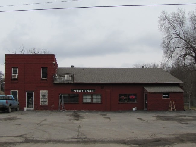
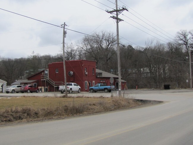
Property Record
11909 Calhoun Rd, Omaha, NE 68152

Property Detail
11909 Calhoun Rd
3494-0000-02
LANDS SEC-TWN-RGE 08-16-13 N OF H/W & E OF PONCA RD IRREG 0.77 AC T L 4
Bartavern
Douglas
CC
Nebraska
AE The base floodplain where base flood elevations are provided. AE Zones are now used on new format FIRMs instead of A1-A30 Zones.
4
2024
0.77 AC
2025
Northeast Omaha
007303
Omaha/Council Bluffs
4,352 SF
Omaha, NE-IA
NEARBY LISTINGS FOR SALE OR LEASE
-
-
View all Omaha listings for sale on LoopNet.com
DEMOGRAPHICS near 11909 Calhoun Rd
1 mile
3 mile
5 mile
2025 Total Population
1,003
7,844
60,240
2030 Population
1,028
8,033
61,980
Pop Growth 2025-2030
+ 2.49%
+ 2.41%
+ 2.89%
Average Age
47
46
38
2025 Total Households
401
3,269
22,127
HH Growth 2025-2030
+ 2.74%
+ 2.63%
+ 3.08%
Median Household Inc
$86,206
$76,253
$60,486
Avg Household Size
2.40
2.40
2.60
2025 Avg HH Vehicles
2.00
2.00
2.00
Median Home Value
$367,123
$322,207
$187,538
Median Year Built
1968
1968
1966
Nearby Places
Map Layers
Map Styles
 Street
 Aerial
Layers
 Traffic
 Biking
Places
Listings with unknown addresses are not visible on the map
- Restaurants
- Banks
- Shops
- Fitness
- Groceries
PUBLIC TRANSPORTATION
AIRPORT
Eppley Airfield
Drive
Walk
Distance
Eppley Airfield
19 min
9.2 mi
SALE & LEASE HISTORY
LISTING DATE
SALE/LEASE

Feb 07, 2017
For Sale
Nearby Properties
Address
Land Use
TOTAL SIZE
Lot Size
Zoning
Address
Land Use
TOTAL SIZE
Lot Size
Zoning
74,015 SF
27.11 AC
DR
Address
Land Use
TOTAL SIZE
Lot Size
Zoning
97,368 SF
5.51 AC
GI
Address
Land Use
TOTAL SIZE
Lot Size
Zoning
92,214 SF
4.67 AC
GI
Address
Land Use
TOTAL SIZE
Lot Size
Zoning
73,976 SF
6.80 AC
Address
Land Use
TOTAL SIZE
Lot Size
Zoning
74,920 SF
4.53 AC
Address
Land Use
TOTAL SIZE
Lot Size
Zoning
167,580 SF
10.63 AC
GI
Address
Land Use
TOTAL SIZE
Lot Size
Zoning
37,120 SF
2.74 AC
CC
Address
Land Use
TOTAL SIZE
Lot Size
Zoning
131,150 SF
3.28 AC
GI
Address
Land Use
TOTAL SIZE
Lot Size
Zoning
17,798 SF
1.78 AC
NBD
Address
Land Use
TOTAL SIZE
Lot Size
Zoning
68,709 SF
3.57 AC
GI
Address
Land Use
TOTAL SIZE
Lot Size
Zoning
2,128 SF
0.43 AC
CC
Address
Land Use
TOTAL SIZE
Lot Size
Zoning
25,240 SF
0.86 AC
GI
Address
Land Use
TOTAL SIZE
Lot Size
Zoning
16,500 SF
1.14 AC
CC
Address
Land Use
TOTAL SIZE
Lot Size
Zoning
10.69 AC
GI
Address
Land Use
TOTAL SIZE
Lot Size
Zoning
64,765 SF
3.86 AC
GI
Address
Land Use
TOTAL SIZE
Lot Size
Zoning
22,560 SF
0.85 AC
GI
Address
Land Use
TOTAL SIZE
Lot Size
Zoning
21,836 SF
4.30 AC
GI
Address
Land Use
TOTAL SIZE
Lot Size
Zoning
19,018 SF
155.26 AC
Address
Land Use
TOTAL SIZE
Lot Size
Zoning
28,458 SF
1.27 AC
R7
Address
Land Use
TOTAL SIZE
Lot Size
Zoning
48,060 SF
2.58 AC
GI
Address
Land Use
TOTAL SIZE
Lot Size
Zoning
12,648 SF
0.43 AC
GI
Address
Land Use
TOTAL SIZE
Lot Size
Zoning
3,329 SF
21.52 AC
Address
Land Use
TOTAL SIZE
Lot Size
Zoning
12,000 SF
0.92 AC
GC
Address
Land Use
TOTAL SIZE
Lot Size
Zoning
15,566 SF
0.65 AC
Address
Land Use
TOTAL SIZE
Lot Size
Zoning
42,780 SF
3.30 AC
GI
Address
Land Use
TOTAL SIZE
Lot Size
Zoning
42,570 SF
1.65 AC
GI
Address
Land Use
TOTAL SIZE
Lot Size
Zoning
27,998 SF
3 AC
Address
Land Use
TOTAL SIZE
Lot Size
Zoning
8,898 SF
0.89 AC
GO
Address
Land Use
TOTAL SIZE
Lot Size
Zoning
4,398 SF
0.91 AC
The World's #1 Commercial Real Estate Marketplace
Connect with us
© 2026 CoStar Group
The information above has been obtained from sources believed reliable. While we do not doubt its accuracy we have not verified it and make no guarantee, warranty or representation about it. It is your responsibility to independently confirm its accuracy and completeness. Any projections, opinions, assumptions, or estimates used are for example only and do not represent the current or future performance of the property. The value of this transaction to you depends on tax and other factors which should be evaluated by your tax, financial, and legal advisors. You and your advisors should conduct a careful, independent investigation of the property to determine to your satisfaction the suitability of the property for your needs.