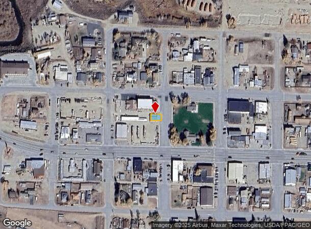
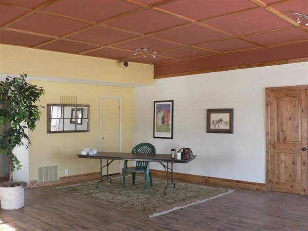
Property Record
1191 N Laurel Valley Ct, Buford, GA 30519

NEARBY LISTINGS FOR SALE OR LEASE
-
-
View all Buford listings for lease on LoopNet.com
Property Detail
1191 N Laurel Valley Ct
R024190
Kremmling
Officecondo
SUBD: KREMMLING LOT: 14,16 BLOCK: 8 THE E 58FT OF LOT 16 AND THE E 58 FT OF THE S 10 FT OF LOT 14
D
Grand
08049C0650C
Colorado
2025
14,16
2025
0.05 AC
000100
Colorado Northwest Area
1,560 SF
Other Market Areas
DEMOGRAPHICS near 1191 N Laurel Valley Ct
1 mile
3 mile
5 mile
2024 Total Population
1,124
1,381
1,408
2029 Population
1,079
1,326
1,352
Pop Growth 2024-2029
(4.00%)
(3.98%)
(3.98%)
Average Age
39
39
39
2024 Total Households
452
556
567
HH Growth 2024-2029
(4.65%)
(4.68%)
(4.76%)
Median Household Inc
$54,636
$54,632
$55,000
Avg Household Size
2.40
2.40
2.40
2024 Avg HH Vehicles
2.00
2.00
2.00
Median Home Value
$251,063
$252,608
$256,086
Median Year Built
1978
1978
1978
Nearby Places
Map Layers
Map Styles
 Street
 Aerial
Transit
 Traffic
 Biking
Places
Listings with unknown addresses are not visible on the map
- Restaurants
- Banks
- Shops
- Fitness
- Groceries
SALE & LEASE HISTORY
LISTING DATE
SALE/LEASE

Sep 25, 2016
For Lease
Sep 24, 2021
For Lease
May 21, 2018
For Sale
Mar 27, 2017
For Sale
Nearby Properties
Address
Land Use
TOTAL SIZE
Lot Size
Zoning
Address
Land Use
TOTAL SIZE
Lot Size
Zoning
1,960 SF
14.91 AC
33
Address
Land Use
TOTAL SIZE
Lot Size
Zoning
525 SF
15.56 AC
Address
Land Use
TOTAL SIZE
Lot Size
Zoning
25,270 SF
1.77 AC
Address
Land Use
TOTAL SIZE
Lot Size
Zoning
14,525 SF
0.33 AC
33
Address
Land Use
TOTAL SIZE
Lot Size
Zoning
20,420 SF
8.70 AC
Address
Land Use
TOTAL SIZE
Lot Size
Zoning
4,220 SF
3.68 AC
4
Address
Land Use
TOTAL SIZE
Lot Size
Zoning
8,990 SF
0.96 AC
33
Address
Land Use
TOTAL SIZE
Lot Size
Zoning
22,100 SF
0.96 AC
33
Address
Land Use
TOTAL SIZE
Lot Size
Zoning
9,635 SF
2 AC
43
Address
Land Use
TOTAL SIZE
Lot Size
Zoning
13,614 SF
0.73 AC
33
Address
Land Use
TOTAL SIZE
Lot Size
Zoning
18,980 SF
6.57 AC
30
Address
Land Use
TOTAL SIZE
Lot Size
Zoning
10,000 SF
0.48 AC
Address
Land Use
TOTAL SIZE
Lot Size
Zoning
4,578 SF
794.64 AC
Address
Land Use
TOTAL SIZE
Lot Size
Zoning
1,110 SF
29.59 AC
33
Address
Land Use
TOTAL SIZE
Lot Size
Zoning
1,184 SF
7.76 AC
Address
Land Use
TOTAL SIZE
Lot Size
Zoning
8,100 SF
1.35 AC
33
Address
Land Use
TOTAL SIZE
Lot Size
Zoning
3,431 SF
0.37 AC
33
Address
Land Use
TOTAL SIZE
Lot Size
Zoning
14,169 SF
2.25 AC
Address
Land Use
TOTAL SIZE
Lot Size
Zoning
5,926 SF
810.35 AC
Address
Land Use
TOTAL SIZE
Lot Size
Zoning
7,200 SF
1.86 AC
43
Address
Land Use
TOTAL SIZE
Lot Size
Zoning
1,872 SF
1.41 AC
33
Address
Land Use
TOTAL SIZE
Lot Size
Zoning
13,760 SF
2.95 AC
43
Address
Land Use
TOTAL SIZE
Lot Size
Zoning
7,000 SF
0.17 AC
43
Address
Land Use
TOTAL SIZE
Lot Size
Zoning
4,860 SF
2.55 AC
Address
Land Use
TOTAL SIZE
Lot Size
Zoning
1.56 AC
Address
Land Use
TOTAL SIZE
Lot Size
Zoning
29,307 SF
1.30 AC
Address
Land Use
TOTAL SIZE
Lot Size
Zoning
336 SF
35.13 AC
Address
Land Use
TOTAL SIZE
Lot Size
Zoning
3,400 SF
0.61 AC
33
Address
Land Use
TOTAL SIZE
Lot Size
Zoning
2,304 SF
0.25 AC
33
Address
Land Use
TOTAL SIZE
Lot Size
Zoning
6,660 SF
0.93 AC
33
The World's #1 Commercial Real Estate Marketplace
Connect with us
© 2026 CoStar Group
The information above has been obtained from sources believed reliable. While we do not doubt its accuracy we have not verified it and make no guarantee, warranty or representation about it. It is your responsibility to independently confirm its accuracy and completeness. Any projections, opinions, assumptions, or estimates used are for example only and do not represent the current or future performance of the property. The value of this transaction to you depends on tax and other factors which should be evaluated by your tax, financial, and legal advisors. You and your advisors should conduct a careful, independent investigation of the property to determine to your satisfaction the suitability of the property for your needs.