Property Record
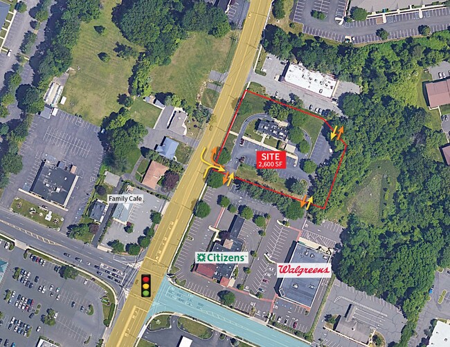
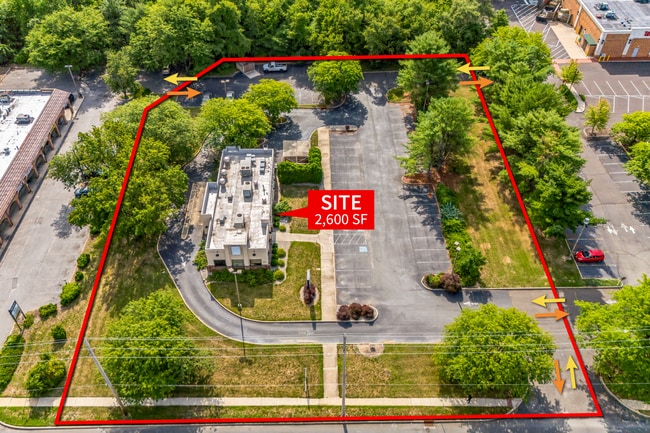
1191 Whitehorse Mercerville Rd, Trenton, NJ 08619

Current Lease Availabilities
Property Detail
1191 Whitehorse Mercerville Rd
03-02168-0000-00017
10078-L
Restaurantdrivein
MERCER
HC
New Jersey
B and X Area of moderate flood hazard, usually the area between the limits of the 100-year and 500-year floods.
17
2024
1.65 AC
2025
Trenton
003009
Northern New Jersey
2,576 SF
Trenton-Princeton, NJ
NEARBY LISTINGS FOR SALE OR LEASE
DEMOGRAPHICS near 1191 Whitehorse Mercerville Rd
1 mile
3 mile
5 mile
2025 Total Population
11,012
117,835
230,938
2030 Population
11,324
120,483
237,782
Pop Growth 2025-2030
+ 2.83%
+ 2.25%
+ 2.96%
Average Age
45
40
40
2025 Total Households
5,128
42,664
84,548
HH Growth 2025-2030
+ 2.85%
+ 2.43%
+ 3.19%
Median Household Inc
$73,395
$85,162
$79,331
Avg Household Size
2.10
2.70
2.60
2025 Avg HH Vehicles
2.00
2.00
2.00
Median Home Value
$295,422
$315,828
$327,350
Median Year Built
1974
1957
1957
Nearby Places
Map Layers
Map Styles
 Street
 Aerial
Layers
 Traffic
 Biking
Places
Listings with unknown addresses are not visible on the map
- Restaurants
- Banks
- Shops
- Fitness
- Groceries
PUBLIC TRANSPORTATION
COMMUTER RAIL
Drive
Walk
Distance
9 min
4.1 mi
Trenton Transit Center (NJT) (Northeast Corridor Line - NJ Transit Commuter Rail (NJ Transit), River LINE - River LINE (River LINE))
Drive
Walk
Distance
Trenton Transit Center (NJT) (Northeast Corridor Line - NJ Transit Commuter Rail (NJ Transit), River LINE - River LINE (River LINE))
10 min
4.1 mi
AIRPORT
Trenton Mercer
Drive
Walk
Distance
Trenton Mercer
20 min
9.9 mi
Philadelphia International
Drive
Walk
Distance
Philadelphia International
66 min
48.0 mi
Freight Ports
Port of Philadelphia
Drive
Walk
Distance
Port of Philadelphia
50 min
33.1 mi
Nearby Properties
Address
Land Use
TOTAL SIZE
Lot Size
Zoning
Address
Land Use
TOTAL SIZE
Lot Size
Zoning
31.05 AC
Address
Land Use
TOTAL SIZE
Lot Size
Zoning
23.13 AC
RD
Address
Land Use
TOTAL SIZE
Lot Size
Zoning
35.83 AC
RB
Address
Land Use
TOTAL SIZE
Lot Size
Zoning
30.94 AC
Address
Land Use
TOTAL SIZE
Lot Size
Zoning
60.26 AC
RD
Address
Land Use
TOTAL SIZE
Lot Size
Zoning
585,222 SF
44.82 AC
RD
Address
Land Use
TOTAL SIZE
Lot Size
Zoning
392,050 SF
45.57 AC
Address
Land Use
TOTAL SIZE
Lot Size
Zoning
Address
Land Use
TOTAL SIZE
Lot Size
Zoning
18.33 AC
Address
Land Use
TOTAL SIZE
Lot Size
Zoning
2,920 SF
17.84 AC
HC
Address
Land Use
TOTAL SIZE
Lot Size
Zoning
339,339 SF
33.91 AC
RD
Address
Land Use
TOTAL SIZE
Lot Size
Zoning
9.63 AC
RD
Address
Land Use
TOTAL SIZE
Lot Size
Zoning
23.53 AC
AT
Address
Land Use
TOTAL SIZE
Lot Size
Zoning
27.50 AC
R7
Address
Land Use
TOTAL SIZE
Lot Size
Zoning
Address
Land Use
TOTAL SIZE
Lot Size
Zoning
6.79 AC
R7
Address
Land Use
TOTAL SIZE
Lot Size
Zoning
15.80 AC
C
Address
Land Use
TOTAL SIZE
Lot Size
Zoning
21.62 AC
RD
Address
Land Use
TOTAL SIZE
Lot Size
Zoning
Address
Land Use
TOTAL SIZE
Lot Size
Zoning
156,128 SF
6.33 AC
RB
Address
Land Use
TOTAL SIZE
Lot Size
Zoning
5,079 SF
7.82 AC
Address
Land Use
TOTAL SIZE
Lot Size
Zoning
23,540 SF
18.14 AC
HC
Address
Land Use
TOTAL SIZE
Lot Size
Zoning
9.31 AC
HC
Address
Land Use
TOTAL SIZE
Lot Size
Zoning
16.62 AC
Address
Land Use
TOTAL SIZE
Lot Size
Zoning
60,564 SF
18.37 AC
RD
Address
Land Use
TOTAL SIZE
Lot Size
Zoning
77,722 SF
39.13 AC
Address
Land Use
TOTAL SIZE
Lot Size
Zoning
14,574 SF
20.23 AC
R10
Address
Land Use
TOTAL SIZE
Lot Size
Zoning
93,840 SF
2.89 AC
RD
Address
Land Use
TOTAL SIZE
Lot Size
Zoning
21.91 AC
R10
Address
Land Use
TOTAL SIZE
Lot Size
Zoning
22.39 AC
I
The World's #1 Commercial Real Estate Marketplace
Connect with us
© 2026 CoStar Group
The information above has been obtained from sources believed reliable. While we do not doubt its accuracy we have not verified it and make no guarantee, warranty or representation about it. It is your responsibility to independently confirm its accuracy and completeness. Any projections, opinions, assumptions, or estimates used are for example only and do not represent the current or future performance of the property. The value of this transaction to you depends on tax and other factors which should be evaluated by your tax, financial, and legal advisors. You and your advisors should conduct a careful, independent investigation of the property to determine to your satisfaction the suitability of the property for your needs.