Property Record
11915 31St Ter E, Palmetto, FL 34221


NEARBY LISTINGS FOR SALE OR LEASE
-
-
View all Palmetto listings for sale on LoopNet.com
Property Detail
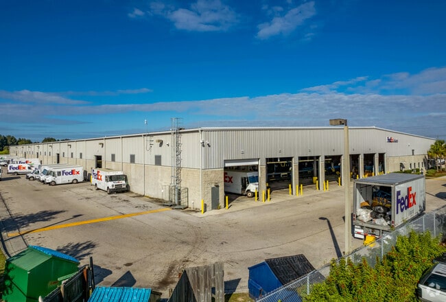
11915 31St Ter E
North Port-Sarasota-Bradenton, FL
Buckeye Industrial Park
6032-0015-9
LOT 1 BUCKEYE INDUSTRIAL PARK PI#6032.0015/9
Warehouse
Manatee
AE
Florida
12081C0156F
1
2023
16.48 AC
2025
Manatee
001602
Tampa/St Petersburg
177,572 SF
DEMOGRAPHICS near 11915 31St Ter E
1 Mile
3 Mile
5 Mile
2024 Total Population
399
9,619
29,381
2029 Population
473
11,375
34,722
Pop Growth 2024-2029
+ 18.55%
+ 18.26%
+ 18.18%
Average Age
41
48
45
2024 Total Households
78
3,349
10,908
HH Growth 2024-2029
+ 20.51%
+ 18.15%
+ 17.46%
Median Household Inc
$68,333
$77,207
$71,579
Avg Household Size
2.60
2.30
2.40
2024 Avg HH Vehicles
2.00
2.00
2.00
Median Home Value
$268,055
$266,212
$265,967
Median Year Built
2006
2003
2000
Nearby Places
Map Layers
Map Styles
 Street
 Aerial
- Restaurants
- Banks
- Shops
- Fitness
- Groceries
PUBLIC TRANSPORTATION
AIRPORT
Sarasota/Bradenton International
DRIVE
WALK
Distance
Sarasota/Bradenton International
30 min
18.1 mi
St Pete-Clearwater International
DRIVE
WALK
Distance
St Pete-Clearwater International
49 min
34.6 mi
Tampa International
DRIVE
WALK
Distance
Tampa International
56 min
43.3 mi
Freight Ports
Port Manatee
DRIVE
WALK
Distance
Port Manatee
7 min
2.2 mi
Nearby Properties
Address
Land Use
TOTAL SIZE
Lot Size
Zoning
Address
Land Use
TOTAL SIZE
Lot Size
Zoning
594,436 SF
68.40 AC
PD-PM
Address
Land Use
TOTAL SIZE
Lot Size
Zoning
359,418 SF
16.36 AC
PD-C
Address
Land Use
TOTAL SIZE
Lot Size
Zoning
350,076 SF
349 AC
PD-PM
Address
Land Use
TOTAL SIZE
Lot Size
Zoning
184,048 SF
21.11 AC
PD-MU
Address
Land Use
TOTAL SIZE
Lot Size
Zoning
322,319 SF
17.98 AC
PD-EZ
Address
Land Use
TOTAL SIZE
Lot Size
Zoning
3,904 SF
94 AC
Address
Land Use
TOTAL SIZE
Lot Size
Zoning
208,893 SF
12.17 AC
PD-MU
Address
Land Use
TOTAL SIZE
Lot Size
Zoning
122,346 SF
12.43 AC
PD-EZ
Address
Land Use
TOTAL SIZE
Lot Size
Zoning
124,400 SF
4.05 AC
PD-MU
Address
Land Use
TOTAL SIZE
Lot Size
Zoning
118,152 SF
30.66 AC
A-1 SUBURB
Address
Land Use
TOTAL SIZE
Lot Size
Zoning
6,552 SF
30.06 AC
RVP
Address
Land Use
TOTAL SIZE
Lot Size
Zoning
137,104 SF
10 AC
PD-EZ
Address
Land Use
TOTAL SIZE
Lot Size
Zoning
3.09 AC
PD-R
Address
Land Use
TOTAL SIZE
Lot Size
Zoning
75,001 SF
18.15 AC
PD-C
Address
Land Use
TOTAL SIZE
Lot Size
Zoning
178,041 SF
414.24 AC
PD-PM
Address
Land Use
TOTAL SIZE
Lot Size
Zoning
98,574 SF
5.60 AC
PD-MU
Address
Land Use
TOTAL SIZE
Lot Size
Zoning
2,196 SF
621.99 AC
Address
Land Use
TOTAL SIZE
Lot Size
Zoning
127,606 SF
18.02 AC
LM LIGHT M
Address
Land Use
TOTAL SIZE
Lot Size
Zoning
21.19 AC
Address
Land Use
TOTAL SIZE
Lot Size
Zoning
181.15 AC
AR
Address
Land Use
TOTAL SIZE
Lot Size
Zoning
459 SF
149.45 AC
AR
Address
Land Use
TOTAL SIZE
Lot Size
Zoning
3,800 SF
17.63 AC
PD-RV
Address
Land Use
TOTAL SIZE
Lot Size
Zoning
139,909 SF
3.25 AC
PD-M
Address
Land Use
TOTAL SIZE
Lot Size
Zoning
4,454 SF
1,348.39 AC
PD-R
Address
Land Use
TOTAL SIZE
Lot Size
Zoning
154,940 SF
3.94 AC
PD-M
Address
Land Use
TOTAL SIZE
Lot Size
Zoning
1,890 SF
20.42 AC
PD-RV
Address
Land Use
TOTAL SIZE
Lot Size
Zoning
14,756 SF
82.96 AC
PD
Address
Land Use
TOTAL SIZE
Lot Size
Zoning
7.24 AC
Address
Land Use
TOTAL SIZE
Lot Size
Zoning
61.03 AC
The World's #1 Commercial Real Estate Marketplace
Connect with us
© 2025 CoStar Group
The information above has been obtained from sources believed reliable. While we do not doubt its accuracy we have not verified it and make no guarantee, warranty or representation about it. It is your responsibility to independently confirm its accuracy and completeness. Any projections, opinions, assumptions, or estimates used are for example only and do not represent the current or future performance of the property. The value of this transaction to you depends on tax and other factors which should be evaluated by your tax, financial, and legal advisors. You and your advisors should conduct a careful, independent investigation of the property to determine to your satisfaction the suitability of the property for your needs.