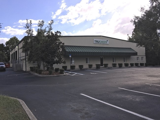
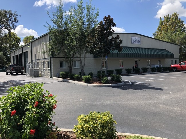
Property Record
11915 Indian Dr, Hudson, FL 34669

NEARBY LISTINGS FOR SALE OR LEASE
Property Detail
11915 Indian Dr
Tampa/St Petersburg
Osceola Heights Highway Addition
Tampa-St. Petersburg-Clearwater, FL
OSCEOLA HEIGHTS HIGHWAY ADDN PB 8 PG 122 TRACTS Y & Z EXC THAT POR LYING IN FOLL PROP:BEGIN AT INTERSECTION OF EAST LINE OF TRACT Z & SLY R/W LINE OF SR 52 TH S79DG 41 50W ALG SAID R/W LINE 212.84 FT TO WEST LINE OF TRACT Y TH S00DG 17 16E ALG SAID W
12-25-16-0110-00000-00Y0
Pasco
Warehouse
Florida
2024
y
2026
1.24 AC
031206
Pasco County
9,164 SF
DEMOGRAPHICS near 11915 Indian Dr
1 Mile
3 Mile
5 Mile
2024 Total Population
4,135
55,522
123,637
2029 Population
4,986
66,538
148,459
Pop Growth 2024-2029
+ 20.58%
+ 19.84%
+ 20.08%
Average Age
44
47
45
2024 Total Households
1,768
24,140
52,722
HH Growth 2024-2029
+ 20.42%
+ 19.79%
+ 20.07%
Median Household Inc
$51,316
$44,265
$47,392
Avg Household Size
2.30
2.20
2.30
2024 Avg HH Vehicles
2.00
2.00
2.00
Median Home Value
$155,309
$151,003
$165,503
Median Year Built
1984
1981
1982
Nearby Places
Map Layers
Map Styles
 Street
 Aerial
- Restaurants
- Banks
- Shops
- Fitness
- Groceries
PUBLIC TRANSPORTATION
AIRPORT
Tampa International
DRIVE
WALK
Distance
Tampa International
49 min
36.0 mi
St Pete-Clearwater International
DRIVE
WALK
Distance
St Pete-Clearwater International
64 min
37.2 mi
Freight Ports
Port of Tampa Bay
DRIVE
WALK
Distance
Port of Tampa Bay
62 min
39.5 mi
SALE & LEASE HISTORY
LISTING DATE
SALE/LEASE

Oct 20, 2016
For Lease
Oct 20, 2016
For Sale
Oct 08, 2018
For Lease
Oct 08, 2018
For Sale
Nearby Properties
Address
Land Use
TOTAL SIZE
Lot Size
Zoning
Address
Land Use
TOTAL SIZE
Lot Size
Zoning
250,601 SF
38.64 AC
C2
Address
Land Use
TOTAL SIZE
Lot Size
Zoning
233,384 SF
29.06 AC
MPUD
Address
Land Use
TOTAL SIZE
Lot Size
Zoning
218,736 SF
39.17 AC
R1
Address
Land Use
TOTAL SIZE
Lot Size
Zoning
459,499 SF
100 AC
AR
Address
Land Use
TOTAL SIZE
Lot Size
Zoning
124,316 SF
22.91 AC
MF1
Address
Land Use
TOTAL SIZE
Lot Size
Zoning
103,743 SF
30.16 AC
MF1
Address
Land Use
TOTAL SIZE
Lot Size
Zoning
189,166 SF
18.19 AC
C2
Address
Land Use
TOTAL SIZE
Lot Size
Zoning
106,741 SF
27.67 AC
MF1
Address
Land Use
TOTAL SIZE
Lot Size
Zoning
217,758 SF
34.95 AC
C2
Address
Land Use
TOTAL SIZE
Lot Size
Zoning
190,794 SF
10.88 AC
C2
Address
Land Use
TOTAL SIZE
Lot Size
Zoning
111,060 SF
9.31 AC
C3
Address
Land Use
TOTAL SIZE
Lot Size
Zoning
75,205 SF
12.71 AC
PUD
Address
Land Use
TOTAL SIZE
Lot Size
Zoning
85,003 SF
25 AC
R4
Address
Land Use
TOTAL SIZE
Lot Size
Zoning
48,470 SF
4.19 AC
MPUD
Address
Land Use
TOTAL SIZE
Lot Size
Zoning
90,113 SF
8.22 AC
C2
Address
Land Use
TOTAL SIZE
Lot Size
Zoning
83,363 SF
5.97 AC
C2
Address
Land Use
TOTAL SIZE
Lot Size
Zoning
78,580 SF
21.43 AC
PUD
Address
Land Use
TOTAL SIZE
Lot Size
Zoning
38,187 SF
6.48 AC
MPUD
Address
Land Use
TOTAL SIZE
Lot Size
Zoning
85,971 SF
16.58 AC
C2
Address
Land Use
TOTAL SIZE
Lot Size
Zoning
188,871 SF
8.44 AC
C1
Address
Land Use
TOTAL SIZE
Lot Size
Zoning
49,118 SF
7.72 AC
C2
Address
Land Use
TOTAL SIZE
Lot Size
Zoning
51,540 SF
3.07 AC
C2
Address
Land Use
TOTAL SIZE
Lot Size
Zoning
83,135 SF
4.49 AC
MF2
Address
Land Use
TOTAL SIZE
Lot Size
Zoning
94,431 SF
10.79 AC
C2
Address
Land Use
TOTAL SIZE
Lot Size
Zoning
120,941 SF
4.66 AC
MF1
Address
Land Use
TOTAL SIZE
Lot Size
Zoning
33,160 SF
8.53 AC
C2
Address
Land Use
TOTAL SIZE
Lot Size
Zoning
64,707 SF
22.64 AC
ER
Address
Land Use
TOTAL SIZE
Lot Size
Zoning
16,030 SF
3.53 AC
R4
Address
Land Use
TOTAL SIZE
Lot Size
Zoning
50,466 SF
2.75 AC
C2
Address
Land Use
TOTAL SIZE
Lot Size
Zoning
48,391 SF
6.02 AC
C2
The World's #1 Commercial Real Estate Marketplace
Connect with us
© 2026 CoStar Group
The information above has been obtained from sources believed reliable. While we do not doubt its accuracy we have not verified it and make no guarantee, warranty or representation about it. It is your responsibility to independently confirm its accuracy and completeness. Any projections, opinions, assumptions, or estimates used are for example only and do not represent the current or future performance of the property. The value of this transaction to you depends on tax and other factors which should be evaluated by your tax, financial, and legal advisors. You and your advisors should conduct a careful, independent investigation of the property to determine to your satisfaction the suitability of the property for your needs.