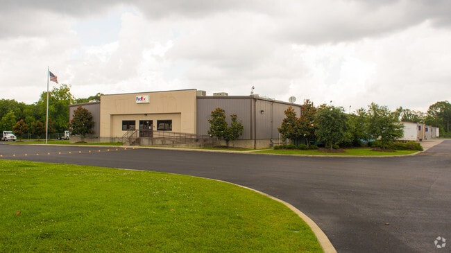
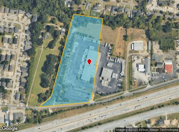
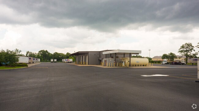
Property Record
11917 N Harrells Ferry Rd, Baton Rouge, LA 70816
NEARBY LISTINGS FOR SALE OR LEASE
Property Detail
11917 N Harrells Ferry Rd
Baton Rouge, LA
Leblanc, P. J. Tract
01330616
WARD: 1-4, SUBDIVISION: LEBLANC, P. J. TRACT, LOT: J-2-B-1-A. LOT J-2-B-1-A, CONT. 9.740 ACRES,RESUBOF LOT J-2-B OF THE P.J.
Storesoffices
E Baton Rouge
AE
Louisiana
22033C0270E
j-2-
2024
9.74 AC
2024
East Baton Rouge Parish North
003912
Baton Rouge
40,574 SF
DEMOGRAPHICS near 11917 N Harrells Ferry Rd
1 Mile
3 Mile
5 Mile
2024 Total Population
14,579
88,396
166,318
2029 Population
14,427
86,626
162,847
Pop Growth 2024-2029
(1.04%)
(2.00%)
(2.09%)
Average Age
36
38
39
2024 Total Households
6,048
36,008
68,762
HH Growth 2024-2029
(1.07%)
(2.17%)
(2.15%)
Median Household Inc
$47,832
$58,599
$58,713
Avg Household Size
2.30
2.40
2.30
2024 Avg HH Vehicles
2.00
2.00
2.00
Median Home Value
$217,210
$209,517
$226,327
Median Year Built
1985
1982
1983
Nearby Places
Map Layers
Map Styles
 Street
 Aerial
- Restaurants
- Banks
- Shops
- Fitness
- Groceries
PUBLIC TRANSPORTATION
AIRPORT
Baton Rouge Metro Ryan Field
DRIVE
WALK
Distance
Baton Rouge Metro Ryan Field
19 min
11.0 mi
Freight Ports
Port of Greater Baton Rouge
DRIVE
WALK
Distance
Port of Greater Baton Rouge
20 min
12.2 mi
Nearby Properties
Address
Land Use
TOTAL SIZE
Lot Size
Zoning
Address
Land Use
TOTAL SIZE
Lot Size
Zoning
365,566 SF
8.77 AC
Address
Land Use
TOTAL SIZE
Lot Size
Zoning
501,688 SF
11.17 AC
Address
Land Use
TOTAL SIZE
Lot Size
Zoning
375,748 SF
25.58 AC
Address
Land Use
TOTAL SIZE
Lot Size
Zoning
281,736 SF
13.13 AC
Address
Land Use
TOTAL SIZE
Lot Size
Zoning
742,463 SF
17.40 AC
Address
Land Use
TOTAL SIZE
Lot Size
Zoning
Address
Land Use
TOTAL SIZE
Lot Size
Zoning
481,760 SF
18.31 AC
Address
Land Use
TOTAL SIZE
Lot Size
Zoning
74,847 SF
9.96 AC
Address
Land Use
TOTAL SIZE
Lot Size
Zoning
98,912 SF
13.75 AC
Address
Land Use
TOTAL SIZE
Lot Size
Zoning
186,400 SF
9.13 AC
Address
Land Use
TOTAL SIZE
Lot Size
Zoning
Address
Land Use
TOTAL SIZE
Lot Size
Zoning
Address
Land Use
TOTAL SIZE
Lot Size
Zoning
Address
Land Use
TOTAL SIZE
Lot Size
Zoning
110,151 SF
16.28 AC
Address
Land Use
TOTAL SIZE
Lot Size
Zoning
Address
Land Use
TOTAL SIZE
Lot Size
Zoning
Address
Land Use
TOTAL SIZE
Lot Size
Zoning
55,824 SF
4.03 AC
Address
Land Use
TOTAL SIZE
Lot Size
Zoning
288,746 SF
12.16 AC
Address
Land Use
TOTAL SIZE
Lot Size
Zoning
152,156 SF
1.53 AC
Address
Land Use
TOTAL SIZE
Lot Size
Zoning
9.45 AC
Address
Land Use
TOTAL SIZE
Lot Size
Zoning
25.54 AC
Address
Land Use
TOTAL SIZE
Lot Size
Zoning
303,400 SF
25.16 AC
Address
Land Use
TOTAL SIZE
Lot Size
Zoning
Address
Land Use
TOTAL SIZE
Lot Size
Zoning
112,314 SF
10.16 AC
Address
Land Use
TOTAL SIZE
Lot Size
Zoning
15.16 AC
Address
Land Use
TOTAL SIZE
Lot Size
Zoning
27,720 SF
1.51 AC
Address
Land Use
TOTAL SIZE
Lot Size
Zoning
17,578 SF
10 AC
Address
Land Use
TOTAL SIZE
Lot Size
Zoning
68,098 SF
4.67 AC
Address
Land Use
TOTAL SIZE
Lot Size
Zoning
13.07 AC
Address
Land Use
TOTAL SIZE
Lot Size
Zoning
199,026 SF
19.52 AC
The World's #1 Commercial Real Estate Marketplace
Connect with us
© 2026 CoStar Group
The information above has been obtained from sources believed reliable. While we do not doubt its accuracy we have not verified it and make no guarantee, warranty or representation about it. It is your responsibility to independently confirm its accuracy and completeness. Any projections, opinions, assumptions, or estimates used are for example only and do not represent the current or future performance of the property. The value of this transaction to you depends on tax and other factors which should be evaluated by your tax, financial, and legal advisors. You and your advisors should conduct a careful, independent investigation of the property to determine to your satisfaction the suitability of the property for your needs.