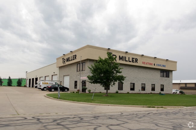
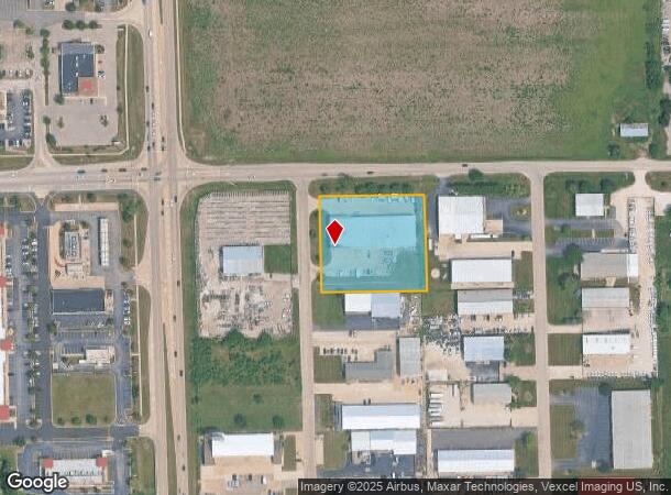
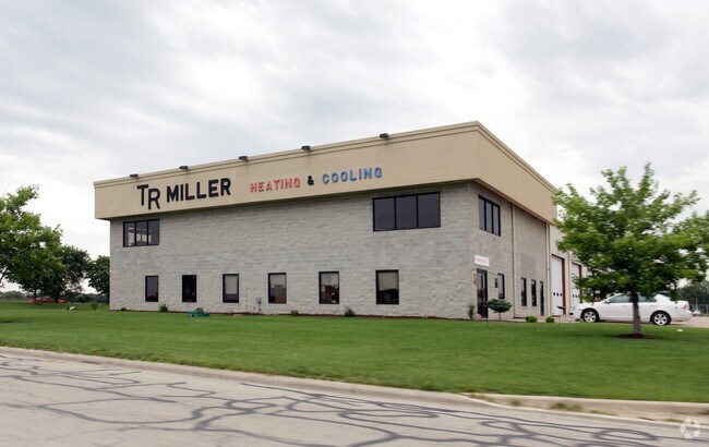
Property Record
11917 S Aero Dr, Plainfield, IL 60585
NEARBY LISTINGS FOR SALE OR LEASE
Property Detail
11917 S Aero Dr
Chicago-Naperville-Elgin, IL-IN-WI
Industrial
07-01-27-102-024
LOT 16 17 IN WOLF CREEK INDUSTRIAL PARK, BEING A SUB OF PRT OF THE W1/2 OF THE NW1/4 OF SEC. 27, T37N-R9E. (EX THAT PRT TAKE
Multipleuses
Will
X
Illinois
17197C0037G
16&17
2024
1.74 AC
2024
I-88 West
880318
Chicago
76,818 SF
DEMOGRAPHICS near 11917 S Aero Dr
1 Mile
3 Mile
5 Mile
2024 Total Population
8,047
53,861
166,355
2029 Population
8,141
53,908
166,805
Pop Growth 2024-2029
+ 1.17%
+ 0.09%
+ 0.27%
Average Age
37
37
38
2024 Total Households
2,566
16,105
52,945
HH Growth 2024-2029
+ 1.29%
+ 0.11%
+ 0.26%
Median Household Inc
$126,649
$163,592
$126,931
Avg Household Size
3.10
3.30
3.10
2024 Avg HH Vehicles
2.00
2.00
2.00
Median Home Value
$404,228
$435,310
$345,921
Median Year Built
2001
2001
1998
Nearby Places
Map Layers
Map Styles
 Street
 Aerial
- Restaurants
- Banks
- Shops
- Fitness
- Groceries
PUBLIC TRANSPORTATION
COMMUTER RAIL
Route 59 Station (Burlington Northern-Santa Fe Railway Line - Northeast Illinois Regional Commuter Railroad (Metra))
DRIVE
WALK
Distance
Route 59 Station (Burlington Northern-Santa Fe Railway Line - Northeast Illinois Regional Commuter Railroad (Metra))
17 min
8.7 mi
AIRPORT
Chicago Midway International
DRIVE
WALK
Distance
Chicago Midway International
40 min
27.5 mi
Chicago O'Hare International
DRIVE
WALK
Distance
Chicago O'Hare International
57 min
39.0 mi
Freight Ports
Port Milwaukee
DRIVE
WALK
Distance
Port Milwaukee
138 min
110.7 mi
Nearby Properties
Address
Land Use
TOTAL SIZE
Lot Size
Zoning
Address
Land Use
TOTAL SIZE
Lot Size
Zoning
952,135 SF
21.86 AC
Address
Land Use
TOTAL SIZE
Lot Size
Zoning
13.71 AC
Address
Land Use
TOTAL SIZE
Lot Size
Zoning
14.59 AC
Address
Land Use
TOTAL SIZE
Lot Size
Zoning
33.04 AC
Address
Land Use
TOTAL SIZE
Lot Size
Zoning
448,352 SF
15.67 AC
Address
Land Use
TOTAL SIZE
Lot Size
Zoning
30.80 AC
Address
Land Use
TOTAL SIZE
Lot Size
Zoning
23.79 AC
Address
Land Use
TOTAL SIZE
Lot Size
Zoning
313,312 SF
17.10 AC
Address
Land Use
TOTAL SIZE
Lot Size
Zoning
29.03 AC
Address
Land Use
TOTAL SIZE
Lot Size
Zoning
232,964 SF
28.66 AC
Address
Land Use
TOTAL SIZE
Lot Size
Zoning
36.79 AC
Address
Land Use
TOTAL SIZE
Lot Size
Zoning
160,039 SF
3.67 AC
Address
Land Use
TOTAL SIZE
Lot Size
Zoning
643,468 SF
14.77 AC
Address
Land Use
TOTAL SIZE
Lot Size
Zoning
409,695 SF
9.41 AC
Address
Land Use
TOTAL SIZE
Lot Size
Zoning
521,457 SF
11.97 AC
Address
Land Use
TOTAL SIZE
Lot Size
Zoning
42.16 AC
Address
Land Use
TOTAL SIZE
Lot Size
Zoning
406,938 SF
9.34 AC
Address
Land Use
TOTAL SIZE
Lot Size
Zoning
326,156 SF
7.49 AC
Address
Land Use
TOTAL SIZE
Lot Size
Zoning
345,727 SF
7.94 AC
Address
Land Use
TOTAL SIZE
Lot Size
Zoning
352,226 SF
8.09 AC
Address
Land Use
TOTAL SIZE
Lot Size
Zoning
236,531 SF
5.43 AC
Address
Land Use
TOTAL SIZE
Lot Size
Zoning
331,797 SF
2.85 AC
Address
Land Use
TOTAL SIZE
Lot Size
Zoning
109,336 SF
2.51 AC
Address
Land Use
TOTAL SIZE
Lot Size
Zoning
225,641 SF
5.03 AC
Address
Land Use
TOTAL SIZE
Lot Size
Zoning
20.40 AC
Address
Land Use
TOTAL SIZE
Lot Size
Zoning
19.25 AC
Address
Land Use
TOTAL SIZE
Lot Size
Zoning
171,670 SF
3.94 AC
Address
Land Use
TOTAL SIZE
Lot Size
Zoning
4.71 AC
Address
Land Use
TOTAL SIZE
Lot Size
Zoning
394,959 SF
9.07 AC
Address
Land Use
TOTAL SIZE
Lot Size
Zoning
The World's #1 Commercial Real Estate Marketplace
Connect with us
© 2025 CoStar Group
The information above has been obtained from sources believed reliable. While we do not doubt its accuracy we have not verified it and make no guarantee, warranty or representation about it. It is your responsibility to independently confirm its accuracy and completeness. Any projections, opinions, assumptions, or estimates used are for example only and do not represent the current or future performance of the property. The value of this transaction to you depends on tax and other factors which should be evaluated by your tax, financial, and legal advisors. You and your advisors should conduct a careful, independent investigation of the property to determine to your satisfaction the suitability of the property for your needs.