Property Record
11918 Mancini Way, New Port Richey, FL 34654
NEARBY LISTINGS FOR SALE OR LEASE
Property Detail
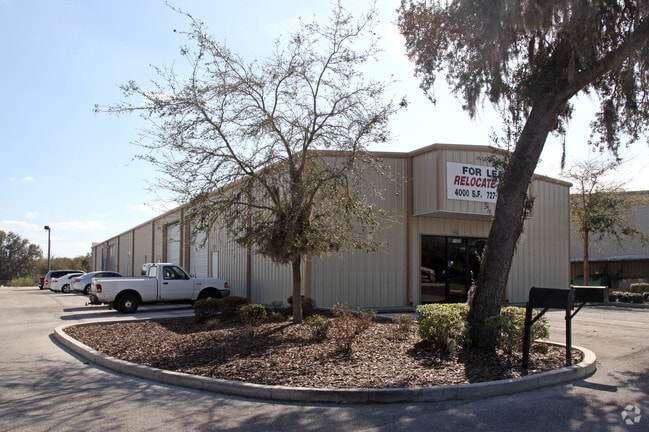
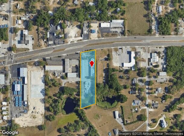
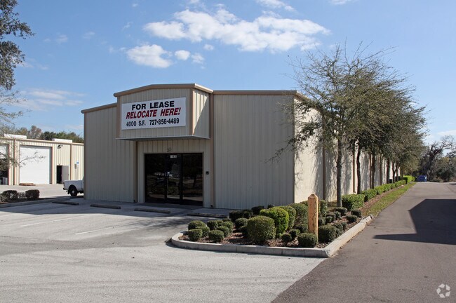
11918 Mancini Way
Tampa-St. Petersburg-Clearwater, FL
Forest Acres
07-25-17-0010-00000-0050
FOREST ACRES UNIT ONE PB 8 PG 72 TRACT 5 EXC THAT POR LYING IN FOLL DESC PROP: COM AT INTERSECTION OF SLY R/W LINE OF SR 52 & WLY LINE OF TRACT 3 FOR POB TH S00DG 22 03W ALG SAID WLY LINE 27.54 FT TH N79 DG 41 56E 357.46 FT TO PC TH 221.66 FT ALG ARC
Warehouse
Pasco
X
Florida
12101C0184F
5
2024
2.47 AC
2025
Pasco County
031301
Tampa/St Petersburg
16,480 SF
DEMOGRAPHICS near 11918 Mancini Way
1 Mile
3 Mile
5 Mile
2024 Total Population
3,912
52,901
122,671
2029 Population
4,714
63,442
147,339
Pop Growth 2024-2029
+ 20.50%
+ 19.93%
+ 20.11%
Average Age
45
47
45
2024 Total Households
1,681
23,012
52,258
HH Growth 2024-2029
+ 20.35%
+ 19.87%
+ 20.10%
Median Household Inc
$51,530
$44,759
$47,548
Avg Household Size
2.30
2.20
2.30
2024 Avg HH Vehicles
2.00
2.00
2.00
Median Home Value
$161,383
$152,883
$166,233
Median Year Built
1985
1982
1982
Nearby Places
Map Layers
Map Styles
 Street
 Aerial
- Restaurants
- Banks
- Shops
- Fitness
- Groceries
PUBLIC TRANSPORTATION
AIRPORT
Tampa International
DRIVE
WALK
Distance
Tampa International
49 min
35.8 mi
St Pete-Clearwater International
DRIVE
WALK
Distance
St Pete-Clearwater International
64 min
37.7 mi
Freight Ports
Port of Tampa Bay
DRIVE
WALK
Distance
Port of Tampa Bay
62 min
39.4 mi
Nearby Properties
Address
Land Use
TOTAL SIZE
Lot Size
Zoning
Address
Land Use
TOTAL SIZE
Lot Size
Zoning
250,601 SF
38.64 AC
C2
Address
Land Use
TOTAL SIZE
Lot Size
Zoning
233,384 SF
29.06 AC
MPUD
Address
Land Use
TOTAL SIZE
Lot Size
Zoning
218,736 SF
39.17 AC
R1
Address
Land Use
TOTAL SIZE
Lot Size
Zoning
459,499 SF
100 AC
AR
Address
Land Use
TOTAL SIZE
Lot Size
Zoning
124,316 SF
22.91 AC
MF1
Address
Land Use
TOTAL SIZE
Lot Size
Zoning
103,743 SF
30.16 AC
MF1
Address
Land Use
TOTAL SIZE
Lot Size
Zoning
189,166 SF
18.19 AC
C2
Address
Land Use
TOTAL SIZE
Lot Size
Zoning
106,741 SF
27.67 AC
MF1
Address
Land Use
TOTAL SIZE
Lot Size
Zoning
190,794 SF
10.88 AC
C2
Address
Land Use
TOTAL SIZE
Lot Size
Zoning
75,205 SF
12.71 AC
PUD
Address
Land Use
TOTAL SIZE
Lot Size
Zoning
85,003 SF
25 AC
R4
Address
Land Use
TOTAL SIZE
Lot Size
Zoning
48,470 SF
4.19 AC
MPUD
Address
Land Use
TOTAL SIZE
Lot Size
Zoning
78,580 SF
21.43 AC
PUD
Address
Land Use
TOTAL SIZE
Lot Size
Zoning
38,187 SF
6.48 AC
MPUD
Address
Land Use
TOTAL SIZE
Lot Size
Zoning
85,971 SF
16.58 AC
C2
Address
Land Use
TOTAL SIZE
Lot Size
Zoning
188,871 SF
8.44 AC
C1
Address
Land Use
TOTAL SIZE
Lot Size
Zoning
49,118 SF
7.72 AC
C2
Address
Land Use
TOTAL SIZE
Lot Size
Zoning
83,135 SF
4.49 AC
MF2
Address
Land Use
TOTAL SIZE
Lot Size
Zoning
33,160 SF
8.53 AC
C2
Address
Land Use
TOTAL SIZE
Lot Size
Zoning
64,707 SF
22.64 AC
ER
Address
Land Use
TOTAL SIZE
Lot Size
Zoning
16,030 SF
3.53 AC
R4
Address
Land Use
TOTAL SIZE
Lot Size
Zoning
50,466 SF
2.75 AC
C2
Address
Land Use
TOTAL SIZE
Lot Size
Zoning
48,391 SF
6.02 AC
C2
Address
Land Use
TOTAL SIZE
Lot Size
Zoning
47,326 SF
8.25 AC
C2
Address
Land Use
TOTAL SIZE
Lot Size
Zoning
45,000 SF
4.05 AC
C2
Address
Land Use
TOTAL SIZE
Lot Size
Zoning
45,594 SF
7.99 AC
ER
Address
Land Use
TOTAL SIZE
Lot Size
Zoning
48,597 SF
14.45 AC
R4
Address
Land Use
TOTAL SIZE
Lot Size
Zoning
44,147 SF
2.53 AC
C2
Address
Land Use
TOTAL SIZE
Lot Size
Zoning
37,178 SF
6.17 AC
MF2
Address
Land Use
TOTAL SIZE
Lot Size
Zoning
19,076 SF
3.59 AC
C2
The World's #1 Commercial Real Estate Marketplace
Connect with us
© 2025 CoStar Group
The information above has been obtained from sources believed reliable. While we do not doubt its accuracy we have not verified it and make no guarantee, warranty or representation about it. It is your responsibility to independently confirm its accuracy and completeness. Any projections, opinions, assumptions, or estimates used are for example only and do not represent the current or future performance of the property. The value of this transaction to you depends on tax and other factors which should be evaluated by your tax, financial, and legal advisors. You and your advisors should conduct a careful, independent investigation of the property to determine to your satisfaction the suitability of the property for your needs.