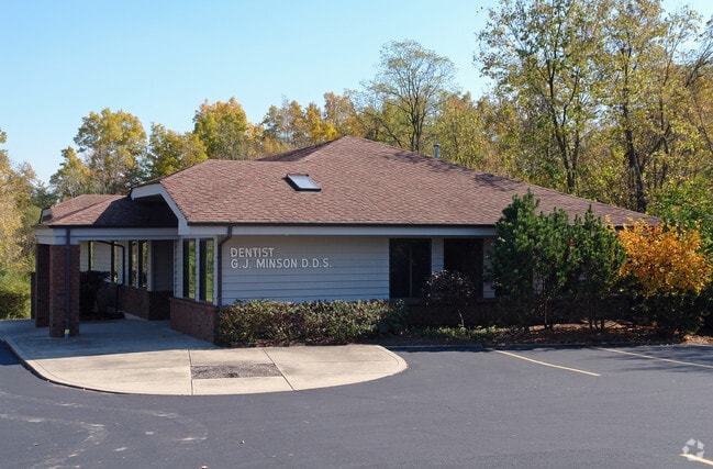
Property Record
11920 Hamilton Ave, Cincinnati, OH 45231
NEARBY LISTINGS FOR SALE OR LEASE
Property Detail
11920 Hamilton Ave
Cincinnati, OH-KY-IN
Harp Huston Sub
590-0415-0028
HAMILTON 0.40 AC PT LOT 3 HARP HUSTON SUB
Medicalbuilding
Hamilton
X
Ohio
39017C0315F
3
2025
0.51 AC
2025
Forest Park/West
021508
Cincinnati/Dayton
DEMOGRAPHICS near 11920 Hamilton Ave
1 mile
3 mile
5 mile
2024 Total Population
8,814
56,184
146,039
2029 Population
8,589
55,759
145,824
Pop Growth 2024-2029
(2.55%)
(0.76%)
(0.15%)
Average Age
41
41
41
2024 Total Households
3,235
21,219
58,166
HH Growth 2024-2029
(2.78%)
(0.87%)
(0.11%)
Median Household Inc
$78,338
$71,160
$64,043
Avg Household Size
2.60
2.60
2.40
2024 Avg HH Vehicles
2.00
2.00
2.00
Median Home Value
$175,893
$176,212
$162,237
Median Year Built
1975
1975
1972
Nearby Places
Map Layers
Map Styles
 Street
 Aerial
Transit
 Traffic
 Biking
Places
Listings with unknown addresses are not visible on the map
- Restaurants
- Banks
- Shops
- Fitness
- Groceries
PUBLIC TRANSPORTATION
AIRPORT
Cincinnati/Northern Kentucky International
Drive
Walk
Distance
Cincinnati/Northern Kentucky International
53 min
38.3 mi
Freight Ports
Port of Toledo
Drive
Walk
Distance
Port of Toledo
231 min
198.5 mi
SALE & LEASE HISTORY
LISTING DATE
SALE/LEASE

Sep 28, 2017
For Lease
Sep 25, 2016
For Lease
Nearby Properties
Address
Land Use
TOTAL SIZE
Lot Size
Zoning
Address
Land Use
TOTAL SIZE
Lot Size
Zoning
40,006 SF
17.23 AC
Address
Land Use
TOTAL SIZE
Lot Size
Zoning
38,880 SF
20.93 AC
Address
Land Use
TOTAL SIZE
Lot Size
Zoning
34.60 AC
Address
Land Use
TOTAL SIZE
Lot Size
Zoning
1,363,493 SF
75.28 AC
Address
Land Use
TOTAL SIZE
Lot Size
Zoning
52,548 SF
39.18 AC
Address
Land Use
TOTAL SIZE
Lot Size
Zoning
44.58 AC
Address
Land Use
TOTAL SIZE
Lot Size
Zoning
4,849 SF
19.98 AC
Address
Land Use
TOTAL SIZE
Lot Size
Zoning
20.68 AC
Address
Land Use
TOTAL SIZE
Lot Size
Zoning
357,452 SF
26.77 AC
Address
Land Use
TOTAL SIZE
Lot Size
Zoning
279,161 SF
28.02 AC
Address
Land Use
TOTAL SIZE
Lot Size
Zoning
3,538 SF
23.40 AC
Address
Land Use
TOTAL SIZE
Lot Size
Zoning
3,894 SF
14.54 AC
Address
Land Use
TOTAL SIZE
Lot Size
Zoning
5,073 SF
14.07 AC
Address
Land Use
TOTAL SIZE
Lot Size
Zoning
183,864 SF
25.85 AC
Address
Land Use
TOTAL SIZE
Lot Size
Zoning
52,138 SF
17.43 AC
Address
Land Use
TOTAL SIZE
Lot Size
Zoning
143,569 SF
10.43 AC
Address
Land Use
TOTAL SIZE
Lot Size
Zoning
Address
Land Use
TOTAL SIZE
Lot Size
Zoning
166,800 SF
15.25 AC
Address
Land Use
TOTAL SIZE
Lot Size
Zoning
3,996 SF
14.27 AC
Address
Land Use
TOTAL SIZE
Lot Size
Zoning
174,444 SF
16.16 AC
Address
Land Use
TOTAL SIZE
Lot Size
Zoning
125,384 SF
13.68 AC
Address
Land Use
TOTAL SIZE
Lot Size
Zoning
67,916 SF
13.73 AC
Address
Land Use
TOTAL SIZE
Lot Size
Zoning
144,922 SF
3.91 AC
Address
Land Use
TOTAL SIZE
Lot Size
Zoning
123,662 SF
2.86 AC
Address
Land Use
TOTAL SIZE
Lot Size
Zoning
3,000 SF
29.22 AC
Address
Land Use
TOTAL SIZE
Lot Size
Zoning
11,316 SF
8.43 AC
RPUD
Address
Land Use
TOTAL SIZE
Lot Size
Zoning
14.27 AC
Address
Land Use
TOTAL SIZE
Lot Size
Zoning
229,447 SF
26.06 AC
Address
Land Use
TOTAL SIZE
Lot Size
Zoning
Address
Land Use
TOTAL SIZE
Lot Size
Zoning
15.25 AC
The World's #1 Commercial Real Estate Marketplace
Connect with us
© 2026 CoStar Group
The information above has been obtained from sources believed reliable. While we do not doubt its accuracy we have not verified it and make no guarantee, warranty or representation about it. It is your responsibility to independently confirm its accuracy and completeness. Any projections, opinions, assumptions, or estimates used are for example only and do not represent the current or future performance of the property. The value of this transaction to you depends on tax and other factors which should be evaluated by your tax, financial, and legal advisors. You and your advisors should conduct a careful, independent investigation of the property to determine to your satisfaction the suitability of the property for your needs.