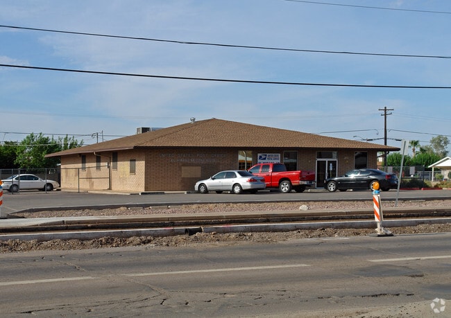
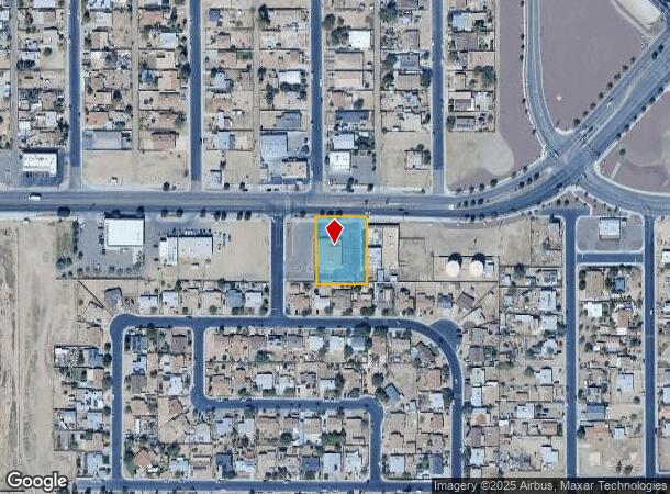
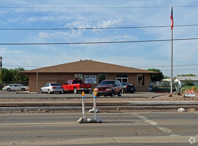
Property Record
11925 W Thunderbird Rd, El Mirage, AZ 85335
NEARBY LISTINGS FOR SALE OR LEASE
Property Detail
11925 W Thunderbird Rd
501-36-115L
Sunnyvale 2
Federalproperty
E 150F OF W 230F OF E 630F OF N 233F OF NE4 NE4 N W4 SD SEC EX N 33F RD
X
Maricopa
04013C1680L
Arizona
0
0.69 AC
2025
Loop 303/Surprise
060903
Phoenix
4,712 SF
Phoenix-Mesa-Scottsdale, AZ
DEMOGRAPHICS near 11925 W Thunderbird Rd
1 Mile
3 Mile
5 Mile
2024 Total Population
19,534
97,644
245,204
2029 Population
20,994
105,781
265,988
Pop Growth 2024-2029
+ 7.47%
+ 8.33%
+ 8.48%
Average Age
34
46
47
2024 Total Households
5,701
39,448
102,235
HH Growth 2024-2029
+ 7.65%
+ 8.62%
+ 8.70%
Median Household Inc
$62,028
$57,619
$62,091
Avg Household Size
3.30
2.40
2.30
2024 Avg HH Vehicles
2.00
2.00
2.00
Median Home Value
$241,681
$256,524
$286,637
Median Year Built
2001
1989
1991
Nearby Places
Map Layers
Map Styles
 Street
 Aerial
- Restaurants
- Banks
- Shops
- Fitness
- Groceries
PUBLIC TRANSPORTATION
AIRPORT
Phoenix Sky Harbor International
DRIVE
WALK
Distance
Phoenix Sky Harbor International
42 min
30.5 mi
Nearby Properties
Address
Land Use
TOTAL SIZE
Lot Size
Zoning
Address
Land Use
TOTAL SIZE
Lot Size
Zoning
35.74 AC
Address
Land Use
TOTAL SIZE
Lot Size
Zoning
1,010,365 SF
29.94 AC
C2
Address
Land Use
TOTAL SIZE
Lot Size
Zoning
53.02 AC
Address
Land Use
TOTAL SIZE
Lot Size
Zoning
16,341 SF
174.45 AC
R-43
Address
Land Use
TOTAL SIZE
Lot Size
Zoning
1,113,127 SF
48.24 AC
C2
Address
Land Use
TOTAL SIZE
Lot Size
Zoning
294,360 SF
21.69 AC
EI
Address
Land Use
TOTAL SIZE
Lot Size
Zoning
225,457 SF
70.07 AC
PAD
Address
Land Use
TOTAL SIZE
Lot Size
Zoning
20,948 SF
2.39 AC
R-6
Address
Land Use
TOTAL SIZE
Lot Size
Zoning
418,305 SF
24.06 AC
PAD
Address
Land Use
TOTAL SIZE
Lot Size
Zoning
333,066 SF
16.33 AC
PAD
Address
Land Use
TOTAL SIZE
Lot Size
Zoning
38,400 SF
4.97 AC
I-2
Address
Land Use
TOTAL SIZE
Lot Size
Zoning
247,178 SF
33.92 AC
PAD
Address
Land Use
TOTAL SIZE
Lot Size
Zoning
106,356 SF
14.16 AC
PAD
Address
Land Use
TOTAL SIZE
Lot Size
Zoning
77,400 SF
20.34 AC
PAD
Address
Land Use
TOTAL SIZE
Lot Size
Zoning
145,491 SF
37.61 AC
PAD
Address
Land Use
TOTAL SIZE
Lot Size
Zoning
707,380 SF
46.26 AC
I-2
Address
Land Use
TOTAL SIZE
Lot Size
Zoning
67,932 SF
14.90 AC
PAD
Address
Land Use
TOTAL SIZE
Lot Size
Zoning
199,390 SF
24.59 AC
C-C
Address
Land Use
TOTAL SIZE
Lot Size
Zoning
65,749 SF
14.58 AC
PAD
Address
Land Use
TOTAL SIZE
Lot Size
Zoning
270,000 SF
16.26 AC
PAD
Address
Land Use
TOTAL SIZE
Lot Size
Zoning
153,525 SF
14.48 AC
PAD
Address
Land Use
TOTAL SIZE
Lot Size
Zoning
112,957 SF
17.40 AC
PAD
Address
Land Use
TOTAL SIZE
Lot Size
Zoning
151,598 SF
9.89 AC
PAD
Address
Land Use
TOTAL SIZE
Lot Size
Zoning
123,820 SF
4.53 AC
C-C
Address
Land Use
TOTAL SIZE
Lot Size
Zoning
19,858 SF
0.64 AC
C-2
Address
Land Use
TOTAL SIZE
Lot Size
Zoning
296,540 SF
11 AC
Address
Land Use
TOTAL SIZE
Lot Size
Zoning
97,910 SF
26.16 AC
PAD
Address
Land Use
TOTAL SIZE
Lot Size
Zoning
94,438 SF
12 AC
PAD
Address
Land Use
TOTAL SIZE
Lot Size
Zoning
199,545 SF
8.99 AC
PAD
Address
Land Use
TOTAL SIZE
Lot Size
Zoning
137,467 SF
9.49 AC
PAD
The World's #1 Commercial Real Estate Marketplace
Connect with us
© 2025 CoStar Group
The information above has been obtained from sources believed reliable. While we do not doubt its accuracy we have not verified it and make no guarantee, warranty or representation about it. It is your responsibility to independently confirm its accuracy and completeness. Any projections, opinions, assumptions, or estimates used are for example only and do not represent the current or future performance of the property. The value of this transaction to you depends on tax and other factors which should be evaluated by your tax, financial, and legal advisors. You and your advisors should conduct a careful, independent investigation of the property to determine to your satisfaction the suitability of the property for your needs.