Property Record
11931 Edison Hwy, Bakersfield, CA 93307


NEARBY LISTINGS FOR SALE OR LEASE
-
-
View all Bakersfield listings for sale on LoopNet.com
Property Detail
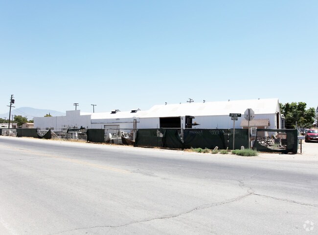
11931 Edison Hwy
Bakersfield, CA
Phillips Tract
177-071-01-00-0
CITY PHLPS , BLOCK , LOT P 1
Lightindustrial
Kern
X
California
06029C2350E
p
2024
0.90 AC
2025
SE Outlying Kern County
001001
Bakersfield
18,358 SF
DEMOGRAPHICS near 11931 Edison Hwy
1 Mile
3 Mile
5 Mile
2024 Total Population
152
10,474
64,142
2029 Population
146
10,384
64,285
Pop Growth 2024-2029
(3.95%)
(0.86%)
+ 0.22%
Average Age
36
33
34
2024 Total Households
48
2,761
18,525
HH Growth 2024-2029
(4.17%)
(1.05%)
+ 0.22%
Median Household Inc
$78,846
$53,711
$59,374
Avg Household Size
3.10
3.70
3.40
2024 Avg HH Vehicles
2.00
2.00
2.00
Median Home Value
$254,545
$251,572
$274,186
Median Year Built
1990
1990
1988
Nearby Places
Map Layers
Map Styles
 Street
 Aerial
- Restaurants
- Banks
- Shops
- Fitness
- Groceries
PUBLIC TRANSPORTATION
AIRPORT
Meadows Field
DRIVE
WALK
Distance
Meadows Field
27 min
16.6 mi
Nearby Properties
Address
Land Use
TOTAL SIZE
Lot Size
Zoning
Address
Land Use
TOTAL SIZE
Lot Size
Zoning
50,445 SF
2.53 AC
C2
Address
Land Use
TOTAL SIZE
Lot Size
Zoning
17.85 AC
M3
Address
Land Use
TOTAL SIZE
Lot Size
Zoning
33,264 SF
28.68 AC
AG
Address
Land Use
TOTAL SIZE
Lot Size
Zoning
9,627 SF
12.37 AC
C2
Address
Land Use
TOTAL SIZE
Lot Size
Zoning
97,900 SF
6.98 AC
M-2 PD
Address
Land Use
TOTAL SIZE
Lot Size
Zoning
44,779 SF
2.17 AC
M2
Address
Land Use
TOTAL SIZE
Lot Size
Zoning
39,175 SF
12.21 AC
M2
Address
Land Use
TOTAL SIZE
Lot Size
Zoning
47,592 SF
35.87 AC
M2
Address
Land Use
TOTAL SIZE
Lot Size
Zoning
5.63 AC
C2
Address
Land Use
TOTAL SIZE
Lot Size
Zoning
12,124 SF
10.06 AC
M2
Address
Land Use
TOTAL SIZE
Lot Size
Zoning
113,326 SF
8.35 AC
R2
Address
Land Use
TOTAL SIZE
Lot Size
Zoning
246.66 AC
A
Address
Land Use
TOTAL SIZE
Lot Size
Zoning
1,940 SF
6.43 AC
A
Address
Land Use
TOTAL SIZE
Lot Size
Zoning
30,000 SF
12.56 AC
M-1
Address
Land Use
TOTAL SIZE
Lot Size
Zoning
160.43 AC
A
Address
Land Use
TOTAL SIZE
Lot Size
Zoning
8.90 AC
M
Address
Land Use
TOTAL SIZE
Lot Size
Zoning
78,550 SF
6.99 AC
M1
Address
Land Use
TOTAL SIZE
Lot Size
Zoning
7,054 SF
73 AC
R-1
Address
Land Use
TOTAL SIZE
Lot Size
Zoning
69,600 SF
3.95 AC
C2
Address
Land Use
TOTAL SIZE
Lot Size
Zoning
84,324 SF
6.99 AC
M1
Address
Land Use
TOTAL SIZE
Lot Size
Zoning
6.87 AC
Address
Land Use
TOTAL SIZE
Lot Size
Zoning
9.40 AC
M-2 PD
Address
Land Use
TOTAL SIZE
Lot Size
Zoning
5,456 SF
3.96 AC
M-1
Address
Land Use
TOTAL SIZE
Lot Size
Zoning
29,900 SF
3.61 AC
M-2
Address
Land Use
TOTAL SIZE
Lot Size
Zoning
3,600 SF
4.61 AC
C2
Address
Land Use
TOTAL SIZE
Lot Size
Zoning
9,374 SF
0.93 AC
M-2
Address
Land Use
TOTAL SIZE
Lot Size
Zoning
4,285 SF
0.70 AC
C2
The World's #1 Commercial Real Estate Marketplace
Connect with us
© 2025 CoStar Group
The information above has been obtained from sources believed reliable. While we do not doubt its accuracy we have not verified it and make no guarantee, warranty or representation about it. It is your responsibility to independently confirm its accuracy and completeness. Any projections, opinions, assumptions, or estimates used are for example only and do not represent the current or future performance of the property. The value of this transaction to you depends on tax and other factors which should be evaluated by your tax, financial, and legal advisors. You and your advisors should conduct a careful, independent investigation of the property to determine to your satisfaction the suitability of the property for your needs.