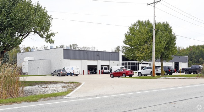
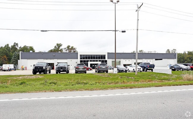
Property Record
11940 Sager Rd, Swanton, OH 43558

Property Detail
11940 Sager Rd
72-09674
9 7 9 SE 1/4 S 20 AC SE1/4 EXC E 8 AC &EXC N 150 FT S 661.4
Vehiclerentalsvehiclesales
Lucas
33-M1
Ohio
B and X Area of moderate flood hazard, usually the area between the limits of the 100-year and 500-year floods.
10.93 AC
0
South/Southwest
2025
Toledo
009500
Toledo, OH
87,090 SF
NEARBY LISTINGS FOR SALE OR LEASE
-
-
View all Swanton listings for lease on LoopNet.com
DEMOGRAPHICS near 11940 Sager Rd
1 mile
3 mile
5 mile
2025 Total Population
103
4,511
20,862
2030 Population
100
4,500
20,648
Pop Growth 2025-2030
(2.91%)
(0.24%)
(1.03%)
Average Age
45
44
43
2025 Total Households
38
1,796
7,922
HH Growth 2025-2030
(2.63%)
(0.11%)
(1.05%)
Median Household Inc
$81,250
$88,130
$94,014
Avg Household Size
2.60
2.50
2.60
2025 Avg HH Vehicles
2.00
2.00
2.00
Median Home Value
$220,000
$258,474
$280,564
Median Year Built
1978
1977
1979
Nearby Places
Map Layers
Map Styles
 Street
 Aerial
Layers
 Traffic
 Biking
Places
Listings with unknown addresses are not visible on the map
- Restaurants
- Banks
- Shops
- Fitness
- Groceries
PUBLIC TRANSPORTATION
AIRPORT
Eugene F Kranz Toledo Express
Drive
Walk
Distance
Eugene F Kranz Toledo Express
7 min
1.7 mi
Freight Ports
Port of Baltimore
Drive
Walk
Distance
Port of Baltimore
1 min
412.4 mi
SALE & LEASE HISTORY
LISTING DATE
SALE/LEASE

Sep 25, 2016
For Lease
Nearby Properties
Address
Land Use
TOTAL SIZE
Lot Size
Zoning
Address
Land Use
TOTAL SIZE
Lot Size
Zoning
178,278 SF
399.08 AC
33-A
Address
Land Use
TOTAL SIZE
Lot Size
Zoning
372,117 SF
35 AC
17-AR
Address
Land Use
TOTAL SIZE
Lot Size
Zoning
8,571 SF
43.96 AC
18-R1
Address
Land Use
TOTAL SIZE
Lot Size
Zoning
1,176 SF
626.54 AC
17-AR
Address
Land Use
TOTAL SIZE
Lot Size
Zoning
262.63 AC
33-MX
Address
Land Use
TOTAL SIZE
Lot Size
Zoning
131,800 SF
9.55 AC
33-M1
Address
Land Use
TOTAL SIZE
Lot Size
Zoning
21.09 AC
33-A
Address
Land Use
TOTAL SIZE
Lot Size
Zoning
77,220 SF
262.63 AC
33-MX
Address
Land Use
TOTAL SIZE
Lot Size
Zoning
323,240 SF
21.09 AC
33-A
Address
Land Use
TOTAL SIZE
Lot Size
Zoning
228.67 AC
33-MX
Address
Land Use
TOTAL SIZE
Lot Size
Zoning
100,000 SF
6.70 AC
33-M1
Address
Land Use
TOTAL SIZE
Lot Size
Zoning
102,232 SF
6.29 AC
33-MX
Address
Land Use
TOTAL SIZE
Lot Size
Zoning
68,395 SF
398.85 AC
33-A
Address
Land Use
TOTAL SIZE
Lot Size
Zoning
9,381 SF
414.42 AC
33-A
Address
Land Use
TOTAL SIZE
Lot Size
Zoning
665.87 AC
17-AR
Address
Land Use
TOTAL SIZE
Lot Size
Zoning
30,012 SF
3.44 AC
19-RA3
Address
Land Use
TOTAL SIZE
Lot Size
Zoning
58,438 SF
398.85 AC
33-A
Address
Land Use
TOTAL SIZE
Lot Size
Zoning
32,704 SF
1.18 AC
33-A
Address
Land Use
TOTAL SIZE
Lot Size
Zoning
37,432 SF
5.05 AC
19-RA3
Address
Land Use
TOTAL SIZE
Lot Size
Zoning
21,284 SF
111.40 AC
18-B3
Address
Land Use
TOTAL SIZE
Lot Size
Zoning
39,924 SF
1.63 AC
33-A
Address
Land Use
TOTAL SIZE
Lot Size
Zoning
9,920 SF
26.76 AC
18-B3
Address
Land Use
TOTAL SIZE
Lot Size
Zoning
32,883 SF
1.30 AC
33-A
Address
Land Use
TOTAL SIZE
Lot Size
Zoning
54,293 SF
4.96 AC
B3
Address
Land Use
TOTAL SIZE
Lot Size
Zoning
27,412 SF
1 AC
17-C2
Address
Land Use
TOTAL SIZE
Lot Size
Zoning
32,643 SF
3.42 AC
17-AR
Address
Land Use
TOTAL SIZE
Lot Size
Zoning
42,652 SF
3.49 AC
33-A
Address
Land Use
TOTAL SIZE
Lot Size
Zoning
72,652 SF
4.52 AC
33-A
Address
Land Use
TOTAL SIZE
Lot Size
Zoning
79,400 SF
28.04 AC
33-MX
Address
Land Use
TOTAL SIZE
Lot Size
Zoning
50,451 SF
5.63 AC
17-MX
The World's #1 Commercial Real Estate Marketplace
Connect with us
© 2026 CoStar Group
The information above has been obtained from sources believed reliable. While we do not doubt its accuracy we have not verified it and make no guarantee, warranty or representation about it. It is your responsibility to independently confirm its accuracy and completeness. Any projections, opinions, assumptions, or estimates used are for example only and do not represent the current or future performance of the property. The value of this transaction to you depends on tax and other factors which should be evaluated by your tax, financial, and legal advisors. You and your advisors should conduct a careful, independent investigation of the property to determine to your satisfaction the suitability of the property for your needs.