Property Record
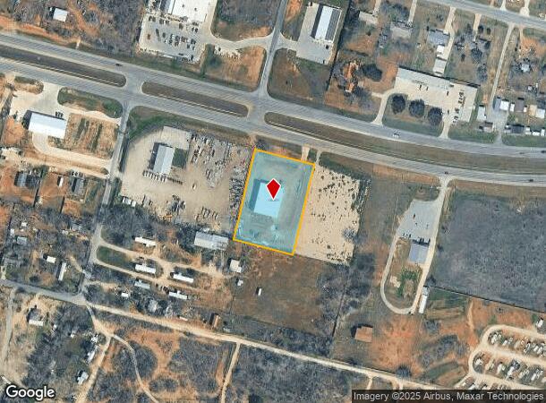
11940 Us Highway 87 E, Adkins, TX 78101

NEARBY LISTINGS FOR SALE OR LEASE
Property Detail
11940 Us Highway 87 E
San Antonio-New Braunfels, TX
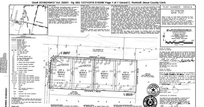
Cb 5141A (Mkm Plat)
05141-102-0070
CB 5141A (MKM PLAT), BLOCK 2 LOT 7 2019-CREATED PER PLAT 20001/665 FILED 12-21-2018
Vacantlandnec
Bexar
X
Texas
48029C0610G
7
2024
1.89 AC
2025
South
141900
San Antonio
DEMOGRAPHICS near 11940 Us Highway 87 E
1 mile
3 mile
5 mile
2024 Total Population
924
3,716
8,849
2029 Population
955
3,865
9,406
Pop Growth 2024-2029
+ 3.35%
+ 4.01%
+ 6.29%
Average Age
42
42
43
2024 Total Households
339
1,373
3,259
HH Growth 2024-2029
+ 3.54%
+ 4.15%
+ 6.35%
Median Household Inc
$61,964
$65,486
$70,820
Avg Household Size
2.70
2.60
2.70
2024 Avg HH Vehicles
3.00
3.00
3.00
Median Home Value
$271,186
$276,458
$279,486
Median Year Built
1987
1989
1989
Nearby Places
Map Layers
Map Styles
 Street
 Aerial
Transit
 Traffic
 Biking
Places
Listings with unknown addresses are not visible on the map
- Restaurants
- Banks
- Shops
- Fitness
- Groceries
PUBLIC TRANSPORTATION
AIRPORT
San Antonio International
Drive
Walk
Distance
San Antonio International
32 min
24.1 mi
Freight Ports
Calhoun Port
Drive
Walk
Distance
Calhoun Port
155 min
130.4 mi
SALE & LEASE HISTORY
LISTING DATE
SALE/LEASE

Jan 20, 2021
For Sale
Aug 25, 2017
For Sale
Nearby Properties
Address
Land Use
TOTAL SIZE
Lot Size
Zoning
Address
Land Use
TOTAL SIZE
Lot Size
Zoning
146.09 AC
Address
Land Use
TOTAL SIZE
Lot Size
Zoning
114.59 AC
Address
Land Use
TOTAL SIZE
Lot Size
Zoning
175.05 AC
Address
Land Use
TOTAL SIZE
Lot Size
Zoning
126.97 AC
Address
Land Use
TOTAL SIZE
Lot Size
Zoning
18,960 SF
3.83 AC
Address
Land Use
TOTAL SIZE
Lot Size
Zoning
156.02 AC
Address
Land Use
TOTAL SIZE
Lot Size
Zoning
61.33 AC
Address
Land Use
TOTAL SIZE
Lot Size
Zoning
84.87 AC
Address
Land Use
TOTAL SIZE
Lot Size
Zoning
86.27 AC
Address
Land Use
TOTAL SIZE
Lot Size
Zoning
44,950 SF
4.56 AC
Address
Land Use
TOTAL SIZE
Lot Size
Zoning
51.95 AC
Address
Land Use
TOTAL SIZE
Lot Size
Zoning
576 SF
85.08 AC
Address
Land Use
TOTAL SIZE
Lot Size
Zoning
952 SF
79.04 AC
Address
Land Use
TOTAL SIZE
Lot Size
Zoning
4,458 SF
48.02 AC
Address
Land Use
TOTAL SIZE
Lot Size
Zoning
5,910 SF
40.74 AC
Address
Land Use
TOTAL SIZE
Lot Size
Zoning
Address
Land Use
TOTAL SIZE
Lot Size
Zoning
9,800 SF
2 AC
Address
Land Use
TOTAL SIZE
Lot Size
Zoning
22,915 SF
9.31 AC
Address
Land Use
TOTAL SIZE
Lot Size
Zoning
2,849 SF
107.47 AC
Address
Land Use
TOTAL SIZE
Lot Size
Zoning
4,592 SF
3.71 AC
Address
Land Use
TOTAL SIZE
Lot Size
Zoning
2,677 SF
112.46 AC
Address
Land Use
TOTAL SIZE
Lot Size
Zoning
11,087 SF
11.11 AC
Address
Land Use
TOTAL SIZE
Lot Size
Zoning
225.30 AC
Address
Land Use
TOTAL SIZE
Lot Size
Zoning
74.05 AC
Address
Land Use
TOTAL SIZE
Lot Size
Zoning
68.81 AC
Address
Land Use
TOTAL SIZE
Lot Size
Zoning
19,848 SF
40.47 AC
Address
Land Use
TOTAL SIZE
Lot Size
Zoning
105.12 AC
Address
Land Use
TOTAL SIZE
Lot Size
Zoning
47.24 AC
Address
Land Use
TOTAL SIZE
Lot Size
Zoning
1,131 SF
62.44 AC
Address
Land Use
TOTAL SIZE
Lot Size
Zoning
The World's #1 Commercial Real Estate Marketplace
Connect with us
© 2026 CoStar Group
The information above has been obtained from sources believed reliable. While we do not doubt its accuracy we have not verified it and make no guarantee, warranty or representation about it. It is your responsibility to independently confirm its accuracy and completeness. Any projections, opinions, assumptions, or estimates used are for example only and do not represent the current or future performance of the property. The value of this transaction to you depends on tax and other factors which should be evaluated by your tax, financial, and legal advisors. You and your advisors should conduct a careful, independent investigation of the property to determine to your satisfaction the suitability of the property for your needs.