Property Record
1197 Euclid Ave, Berkeley, CA 94708
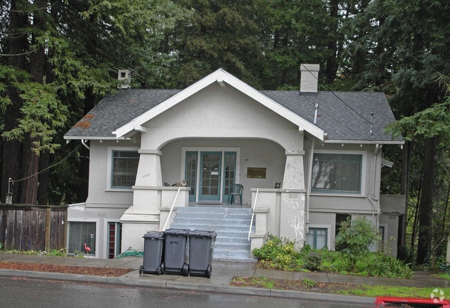


Property Detail
1197 Euclid Ave
Oakland-Fremont-Berkeley, CA
PORTION LOT1
063-2988-065-00
Alameda
Multifamilydwelling
California
B and X Area of moderate flood hazard, usually the area between the limits of the 100-year and 500-year floods.
1
2024
0.23 AC
2025
Berkeley Hills
421500
East Bay/Oakland
4,906 SF
NEARBY LISTINGS FOR SALE OR LEASE
DEMOGRAPHICS near 1197 Euclid Ave
1 mile
3 mile
5 mile
2025 Total Population
26,134
178,874
331,964
2030 Population
26,175
179,084
333,165
Pop Growth 2025-2030
+ 0.16%
+ 0.12%
+ 0.36%
Average Age
42
40
41
2025 Total Households
10,605
69,809
134,825
HH Growth 2025-2030
+ 0.27%
+ 0.18%
+ 0.41%
Median Household Inc
$140,329
$115,202
$120,565
Avg Household Size
2.20
2.30
2.20
2025 Avg HH Vehicles
2.00
1.00
1.00
Median Home Value
$1,119,166
$1,101,492
$1,076,730
Median Year Built
1948
1949
1954
Nearby Places
Map Layers
Map Styles
 Street
 Aerial
Transit
 Traffic
 Biking
Places
Listings with unknown addresses are not visible on the map
- Restaurants
- Banks
- Shops
- Fitness
- Groceries
PUBLIC TRANSPORTATION
COMMUTER RAIL
Berkeley Amtrak (Capitol Corridor - Amtrak)
Drive
Walk
Distance
Berkeley Amtrak (Capitol Corridor - Amtrak)
11 min
3.6 mi
Emeryville (Capitol Corridor - Capitol Corridor Joint Powers Authority)
Drive
Walk
Distance
Emeryville (Capitol Corridor - Capitol Corridor Joint Powers Authority)
14 min
4.5 mi
AIRPORT
Metro Oakland International
Drive
Walk
Distance
Metro Oakland International
28 min
16.2 mi
San Francisco International
Drive
Walk
Distance
San Francisco International
44 min
26.3 mi
Freight Ports
Port of Richmond
Drive
Walk
Distance
Port of Richmond
22 min
10.8 mi
Nearby Properties
Address
Land Use
TOTAL SIZE
Lot Size
Zoning
Address
Land Use
TOTAL SIZE
Lot Size
Zoning
167,071 SF
0.70 AC
Address
Land Use
TOTAL SIZE
Lot Size
Zoning
540,434 SF
14.37 AC
Address
Land Use
TOTAL SIZE
Lot Size
Zoning
395,549 SF
17.05 AC
Address
Land Use
TOTAL SIZE
Lot Size
Zoning
250,642 SF
17.05 AC
Address
Land Use
TOTAL SIZE
Lot Size
Zoning
261,134 SF
2.23 AC
Address
Land Use
TOTAL SIZE
Lot Size
Zoning
169,157 SF
10.20 AC
Address
Land Use
TOTAL SIZE
Lot Size
Zoning
4.77 AC
Address
Land Use
TOTAL SIZE
Lot Size
Zoning
309,451 SF
0.87 AC
Address
Land Use
TOTAL SIZE
Lot Size
Zoning
60,670 SF
1.57 AC
Address
Land Use
TOTAL SIZE
Lot Size
Zoning
123,750 SF
0.81 AC
Address
Land Use
TOTAL SIZE
Lot Size
Zoning
254,000 SF
1.71 AC
Address
Land Use
TOTAL SIZE
Lot Size
Zoning
166,731 SF
0.54 AC
Address
Land Use
TOTAL SIZE
Lot Size
Zoning
86,144 SF
0.52 AC
Address
Land Use
TOTAL SIZE
Lot Size
Zoning
159,705 SF
1.64 AC
COMM
Address
Land Use
TOTAL SIZE
Lot Size
Zoning
65,839 SF
0.62 AC
C2
Address
Land Use
TOTAL SIZE
Lot Size
Zoning
12.31 AC
Address
Land Use
TOTAL SIZE
Lot Size
Zoning
0.61 AC
Address
Land Use
TOTAL SIZE
Lot Size
Zoning
3.61 AC
Address
Land Use
TOTAL SIZE
Lot Size
Zoning
30,500 SF
0.24 AC
R4
Address
Land Use
TOTAL SIZE
Lot Size
Zoning
0.60 AC
Address
Land Use
TOTAL SIZE
Lot Size
Zoning
67,558 SF
0.32 AC
Address
Land Use
TOTAL SIZE
Lot Size
Zoning
136,811 SF
1.01 AC
Address
Land Use
TOTAL SIZE
Lot Size
Zoning
45,500 SF
1.79 AC
Address
Land Use
TOTAL SIZE
Lot Size
Zoning
101,794 SF
0.85 AC
Address
Land Use
TOTAL SIZE
Lot Size
Zoning
83,874 SF
0.60 AC
Address
Land Use
TOTAL SIZE
Lot Size
Zoning
81,410 SF
0.51 AC
Address
Land Use
TOTAL SIZE
Lot Size
Zoning
63,982 SF
0.44 AC
Address
Land Use
TOTAL SIZE
Lot Size
Zoning
75,558 SF
0.52 AC
Address
Land Use
TOTAL SIZE
Lot Size
Zoning
66,235 SF
0.46 AC
Address
Land Use
TOTAL SIZE
Lot Size
Zoning
108,048 SF
1 AC
The World's #1 Commercial Real Estate Marketplace
Connect with us
© 2026 CoStar Group
The information above has been obtained from sources believed reliable. While we do not doubt its accuracy we have not verified it and make no guarantee, warranty or representation about it. It is your responsibility to independently confirm its accuracy and completeness. Any projections, opinions, assumptions, or estimates used are for example only and do not represent the current or future performance of the property. The value of this transaction to you depends on tax and other factors which should be evaluated by your tax, financial, and legal advisors. You and your advisors should conduct a careful, independent investigation of the property to determine to your satisfaction the suitability of the property for your needs.