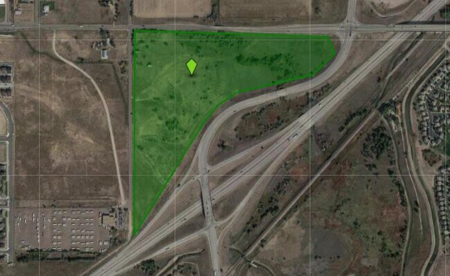
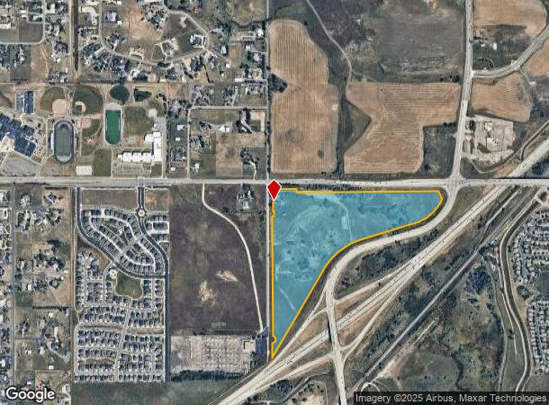
Property Record
11970 Potomac St, Henderson, CO 80640
Property Detail
11970 Potomac St
1723-06-2-00-002
SECT,TWN,RNG:6-2-66 DESC: PARC OF LAND IN THE NW4 OF SEC 6 DESC AS FOLS BEG AT THE NW COR OF SD SEC 6 TH S 86D 20M 56S E 375/79 FT TO THE TRUE POB TH THE FOL 7 COURSES 1)TH S 0D 55M 40S E 90 FT 2)TH N 89D 04M 20S E 1900 FT 3)TH S 23D 57M 01S E 116/18
Residentialacreage
Adams
A
Colorado
08001C0337H
45.72 AC
2024
Northeast Denver
2025
Denver
008557
Denver-Aurora-Centennial, CO
1,092 SF
NEARBY LISTINGS FOR SALE OR LEASE
DEMOGRAPHICS near 11970 Potomac St
1 mile
3 mile
5 mile
2024 Total Population
2,729
37,796
82,597
2029 Population
2,920
40,014
87,223
Pop Growth 2024-2029
+ 7.00%
+ 5.87%
+ 5.60%
Average Age
38
35
35
2024 Total Households
889
11,706
26,579
HH Growth 2024-2029
+ 7.20%
+ 5.95%
+ 5.70%
Median Household Inc
$131,447
$120,837
$112,945
Avg Household Size
3.00
3.20
3.10
2024 Avg HH Vehicles
3.00
2.00
2.00
Median Home Value
$546,496
$469,089
$473,672
Median Year Built
2006
2008
2006
Nearby Places
Map Layers
Map Styles
 Street
 Aerial
Transit
 Traffic
 Biking
Places
Listings with unknown addresses are not visible on the map
- Restaurants
- Banks
- Shops
- Fitness
- Groceries
PUBLIC TRANSPORTATION
COMMUTER RAIL
Thornton Crossroads - 104Th Station Track 1 (Union Station to Eastlake & 124th Station - Regional Transportation District)
Drive
Walk
Distance
Thornton Crossroads - 104Th Station Track 1 (Union Station to Eastlake & 124th Station - Regional Transportation District)
12 min
7.4 mi
Northglenn - 112Th Station Track 2 (Union Station to Eastlake & 124th Station - Regional Transportation District)
Drive
Walk
Distance
Northglenn - 112Th Station Track 2 (Union Station to Eastlake & 124th Station - Regional Transportation District)
14 min
7.7 mi
AIRPORT
Denver International
Drive
Walk
Distance
Denver International
19 min
14.5 mi
Freight Ports
Tulsa Port Of Catoosa
Drive
Walk
Distance
Tulsa Port Of Catoosa
726 min
708.7 mi
Nearby Properties
Address
Land Use
TOTAL SIZE
Lot Size
Zoning
Address
Land Use
TOTAL SIZE
Lot Size
Zoning
279,946 SF
11.55 AC
Address
Land Use
TOTAL SIZE
Lot Size
Zoning
358,386 SF
76.08 AC
Address
Land Use
TOTAL SIZE
Lot Size
Zoning
330,176 SF
17.12 AC
Address
Land Use
TOTAL SIZE
Lot Size
Zoning
298,200 SF
17.67 AC
Address
Land Use
TOTAL SIZE
Lot Size
Zoning
272,800 SF
16.44 AC
Address
Land Use
TOTAL SIZE
Lot Size
Zoning
64,750 SF
11.91 AC
Address
Land Use
TOTAL SIZE
Lot Size
Zoning
121,103 SF
13.47 AC
Address
Land Use
TOTAL SIZE
Lot Size
Zoning
231,205 SF
10.46 AC
Address
Land Use
TOTAL SIZE
Lot Size
Zoning
158,001 SF
20.40 AC
Address
Land Use
TOTAL SIZE
Lot Size
Zoning
Address
Land Use
TOTAL SIZE
Lot Size
Zoning
174.45 AC
Address
Land Use
TOTAL SIZE
Lot Size
Zoning
207,682 SF
7.16 AC
Address
Land Use
TOTAL SIZE
Lot Size
Zoning
121,275 SF
6.56 AC
Address
Land Use
TOTAL SIZE
Lot Size
Zoning
48,359 SF
278.79 AC
A3
Address
Land Use
TOTAL SIZE
Lot Size
Zoning
64,715 SF
10.38 AC
Address
Land Use
TOTAL SIZE
Lot Size
Zoning
106,530 SF
7.04 AC
Address
Land Use
TOTAL SIZE
Lot Size
Zoning
70,573 SF
6.42 AC
Address
Land Use
TOTAL SIZE
Lot Size
Zoning
122,399 SF
14.29 AC
Address
Land Use
TOTAL SIZE
Lot Size
Zoning
55,810 SF
14.52 AC
Address
Land Use
TOTAL SIZE
Lot Size
Zoning
82,239 SF
7.02 AC
Address
Land Use
TOTAL SIZE
Lot Size
Zoning
70,573 SF
14.73 AC
Address
Land Use
TOTAL SIZE
Lot Size
Zoning
79,121 SF
6.39 AC
Address
Land Use
TOTAL SIZE
Lot Size
Zoning
19,341 SF
74.46 AC
Address
Land Use
TOTAL SIZE
Lot Size
Zoning
75,398 SF
8.82 AC
I2
Address
Land Use
TOTAL SIZE
Lot Size
Zoning
102,069 SF
3.26 AC
Address
Land Use
TOTAL SIZE
Lot Size
Zoning
44,215 SF
21.32 AC
Address
Land Use
TOTAL SIZE
Lot Size
Zoning
22,594 SF
19.96 AC
Address
Land Use
TOTAL SIZE
Lot Size
Zoning
42,177 SF
17.73 AC
A3
Address
Land Use
TOTAL SIZE
Lot Size
Zoning
24.65 AC
A3
Address
Land Use
TOTAL SIZE
Lot Size
Zoning
44,077 SF
13.02 AC
The World's #1 Commercial Real Estate Marketplace
Connect with us
© 2026 CoStar Group
The information above has been obtained from sources believed reliable. While we do not doubt its accuracy we have not verified it and make no guarantee, warranty or representation about it. It is your responsibility to independently confirm its accuracy and completeness. Any projections, opinions, assumptions, or estimates used are for example only and do not represent the current or future performance of the property. The value of this transaction to you depends on tax and other factors which should be evaluated by your tax, financial, and legal advisors. You and your advisors should conduct a careful, independent investigation of the property to determine to your satisfaction the suitability of the property for your needs.