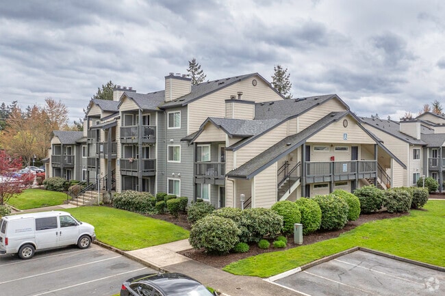
Property Record
11970 Sw Fischer Rd, Portland, OR 97224

Save to a Folder
{{folder.Name}}
{{folder.ListingIds.length}} Properties
{{folder.ListingIds.length}} Property
Create a New Folder
Property Detail
11970 Sw Fischer Rd
R0523179
ACRES 10.01
Apartment
WASHINGTON
R-24
Oregon
B and X Area of moderate flood hazard, usually the area between the limits of the 100-year and 500-year floods.
10.01 AC
2025
Bull Mountain
2026
Portland
030803
Portland-Vancouver-Hillsboro, OR-WA
225,780 SF
NEARBY LISTINGS FOR SALE OR LEASE
DEMOGRAPHICS near 11970 Sw Fischer Rd
1 mile
3 mile
5 mile
2025 Total Population
16,864
92,225
219,364
2030 Population
17,010
93,236
221,817
Pop Growth 2025-2030
+ 0.87%
+ 1.10%
+ 1.12%
Average Age
46
41
41
2025 Total Households
7,694
36,943
85,336
HH Growth 2025-2030
+ 1.03%
+ 1.25%
+ 1.16%
Median Household Inc
$82,569
$103,116
$111,132
Avg Household Size
2.10
2.40
2.50
2025 Avg HH Vehicles
2.00
2.00
2.00
Median Home Value
$476,814
$642,593
$684,286
Median Year Built
1988
1990
1989
Nearby Places
Map Layers
Map Styles
 Street
 Aerial
Layers
 Traffic
 Biking
Places
Listings with unknown addresses are not visible on the map
- Restaurants
- Banks
- Shops
- Fitness
- Groceries
PUBLIC TRANSPORTATION
COMMUTER RAIL
Tualatin (Westside Express Service - Tri-County Metropolitan Transportation District of Oregon Rail (TriMet Rail))
Drive
Walk
Distance
Tualatin (Westside Express Service - Tri-County Metropolitan Transportation District of Oregon Rail (TriMet Rail))
6 min
3.2 mi
Tigard Transit Center (Westside Express Service - Tri-County Metropolitan Transportation District of Oregon Rail (TriMet Rail))
Drive
Walk
Distance
Tigard Transit Center (Westside Express Service - Tri-County Metropolitan Transportation District of Oregon Rail (TriMet Rail))
8 min
3.2 mi
AIRPORT
Portland International
Drive
Walk
Distance
Portland International
40 min
23.7 mi
Freight Ports
Port of Portland
Drive
Walk
Distance
Port of Portland
26 min
14.9 mi
Nearby Properties
Address
Land Use
TOTAL SIZE
Lot Size
Zoning
Address
Land Use
TOTAL SIZE
Lot Size
Zoning
49.34 AC
I-P
Address
Land Use
TOTAL SIZE
Lot Size
Zoning
23.98 AC
EI
Address
Land Use
TOTAL SIZE
Lot Size
Zoning
511,394 SF
18.68 AC
MUC
Address
Land Use
TOTAL SIZE
Lot Size
Zoning
43.20 AC
R-4.5
Address
Land Use
TOTAL SIZE
Lot Size
Zoning
216,381 SF
24.95 AC
CG
Address
Land Use
TOTAL SIZE
Lot Size
Zoning
216,000 SF
64.68 AC
RL
Address
Land Use
TOTAL SIZE
Lot Size
Zoning
14.77 AC
MUE
Address
Land Use
TOTAL SIZE
Lot Size
Zoning
88,000 SF
15.49 AC
R-4.5
Address
Land Use
TOTAL SIZE
Lot Size
Zoning
213,947 SF
14.45 AC
TC-MU
Address
Land Use
TOTAL SIZE
Lot Size
Zoning
27.23 AC
MP
Address
Land Use
TOTAL SIZE
Lot Size
Zoning
0.14 AC
MG
Address
Land Use
TOTAL SIZE
Lot Size
Zoning
9.12 AC
R-7
Address
Land Use
TOTAL SIZE
Lot Size
Zoning
183,133 SF
8.17 AC
R-25
Address
Land Use
TOTAL SIZE
Lot Size
Zoning
174,043 SF
20.35 AC
CC
Address
Land Use
TOTAL SIZE
Lot Size
Zoning
18 AC
RMH
Address
Land Use
TOTAL SIZE
Lot Size
Zoning
88,000 SF
12.62 AC
R-4.5
Address
Land Use
TOTAL SIZE
Lot Size
Zoning
1,232 SF
27.77 AC
EI
Address
Land Use
TOTAL SIZE
Lot Size
Zoning
10.81 AC
RH
Address
Land Use
TOTAL SIZE
Lot Size
Zoning
190,012 SF
4.59 AC
IP
Address
Land Use
TOTAL SIZE
Lot Size
Zoning
294,220 SF
15.10 AC
RH
Address
Land Use
TOTAL SIZE
Lot Size
Zoning
301,940 SF
15.04 AC
MU-CBD
Address
Land Use
TOTAL SIZE
Lot Size
Zoning
18.06 AC
Address
Land Use
TOTAL SIZE
Lot Size
Zoning
68,450 SF
19.39 AC
ML
Address
Land Use
TOTAL SIZE
Lot Size
Zoning
71,930 SF
22.68 AC
CO
Address
Land Use
TOTAL SIZE
Lot Size
Zoning
127,476 SF
13.48 AC
RC
Address
Land Use
TOTAL SIZE
Lot Size
Zoning
121,664 SF
11.65 AC
C-G
Address
Land Use
TOTAL SIZE
Lot Size
Zoning
15,000 SF
21.08 AC
MG
Address
Land Use
TOTAL SIZE
Lot Size
Zoning
22.05 AC
MP
The World's #1 Commercial Real Estate Marketplace
Connect with us
© 2026 CoStar Group
The information above has been obtained from sources believed reliable. While we do not doubt its accuracy we have not verified it and make no guarantee, warranty or representation about it. It is your responsibility to independently confirm its accuracy and completeness. Any projections, opinions, assumptions, or estimates used are for example only and do not represent the current or future performance of the property. The value of this transaction to you depends on tax and other factors which should be evaluated by your tax, financial, and legal advisors. You and your advisors should conduct a careful, independent investigation of the property to determine to your satisfaction the suitability of the property for your needs.