Property Record
11980 State Highway 64 E, Tyler, TX 75707
NEARBY LISTINGS FOR SALE OR LEASE
-
-
View all Tyler listings for sale on LoopNet.com
Property Detail
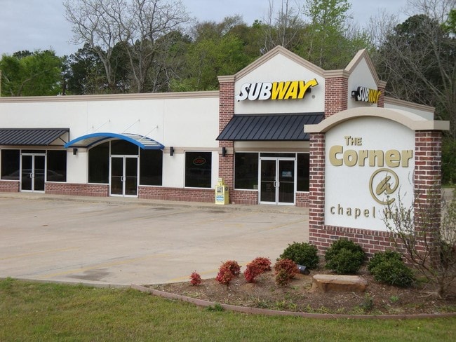
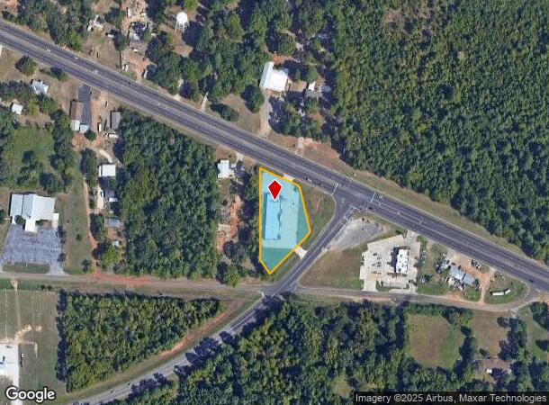
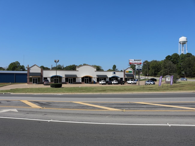
11980 State Highway 64 E
1-00000-1004-00-043040
A1004 E Vansickle
Storebuilding
ABST A1004 E VANSICKLETRACT 43D
X
Smith
48423C0380D
Texas
2024
1.08 AC
2025
Tyler & Longview
001807
Other Market Areas
8,684 SF
Tyler, TX
DEMOGRAPHICS near 11980 State Highway 64 E
1 Mile
3 Mile
5 Mile
2024 Total Population
1,370
14,256
51,206
2029 Population
1,506
15,746
55,866
Pop Growth 2024-2029
+ 9.93%
+ 10.45%
+ 9.10%
Average Age
41
39
38
2024 Total Households
546
5,742
19,706
HH Growth 2024-2029
+ 9.34%
+ 10.24%
+ 8.63%
Median Household Inc
$61,517
$68,901
$63,767
Avg Household Size
2.50
2.30
2.40
2024 Avg HH Vehicles
2.00
2.00
2.00
Median Home Value
$184,146
$191,038
$184,373
Median Year Built
1979
1990
1982
Nearby Places
- Restaurants
- Banks
- Shops
- Fitness
- Groceries
PUBLIC TRANSPORTATION
AIRPORT
Tyler Pounds Regional
DRIVE
WALK
Distance
Tyler Pounds Regional
25 min
14.1 mi
Freight Ports
Port of Shreveport
DRIVE
WALK
Distance
Port of Shreveport
125 min
109.9 mi
SALE & LEASE HISTORY
LISTING DATE
SALE/LEASE

Sep 25, 2016
For Lease
Sep 24, 2016
For Sale
Sep 22, 2023
For Sale
Sep 10, 2020
For Sale
Oct 19, 2021
For Sale
Mar 08, 2018
For Lease
Feb 17, 2023
For Lease
Nearby Properties
Address
Land Use
TOTAL SIZE
Lot Size
Zoning
Address
Land Use
TOTAL SIZE
Lot Size
Zoning
22,500 SF
214.44 AC
R1A
Address
Land Use
TOTAL SIZE
Lot Size
Zoning
3,052 SF
9.20 AC
PMF
Address
Land Use
TOTAL SIZE
Lot Size
Zoning
8,279 SF
14.06 AC
RMF
Address
Land Use
TOTAL SIZE
Lot Size
Zoning
2,676 SF
8.28 AC
RMF
Address
Land Use
TOTAL SIZE
Lot Size
Zoning
2,499 SF
7.77 AC
RMF
Address
Land Use
TOTAL SIZE
Lot Size
Zoning
8,390 SF
12.79 AC
RMF
Address
Land Use
TOTAL SIZE
Lot Size
Zoning
76,216 SF
14.70 AC
PMF
Address
Land Use
TOTAL SIZE
Lot Size
Zoning
27,520 SF
5.91 AC
RMF
Address
Land Use
TOTAL SIZE
Lot Size
Zoning
39.67 AC
Address
Land Use
TOTAL SIZE
Lot Size
Zoning
61,500 SF
82.50 AC
Address
Land Use
TOTAL SIZE
Lot Size
Zoning
4,781 SF
6.32 AC
RMF
Address
Land Use
TOTAL SIZE
Lot Size
Zoning
22.03 AC
R1A
Address
Land Use
TOTAL SIZE
Lot Size
Zoning
1,925 SF
6.78 AC
RMF
Address
Land Use
TOTAL SIZE
Lot Size
Zoning
65,248 SF
21.82 AC
Address
Land Use
TOTAL SIZE
Lot Size
Zoning
13,984 SF
37.24 AC
C2
Address
Land Use
TOTAL SIZE
Lot Size
Zoning
22.62 AC
RMF
Address
Land Use
TOTAL SIZE
Lot Size
Zoning
14.99 AC
C1
Address
Land Use
TOTAL SIZE
Lot Size
Zoning
106,250 SF
19.98 AC
M2
Address
Land Use
TOTAL SIZE
Lot Size
Zoning
28.45 AC
Address
Land Use
TOTAL SIZE
Lot Size
Zoning
18.01 AC
Address
Land Use
TOTAL SIZE
Lot Size
Zoning
20,634 SF
2 AC
Address
Land Use
TOTAL SIZE
Lot Size
Zoning
82,793 SF
1.94 AC
C2
Address
Land Use
TOTAL SIZE
Lot Size
Zoning
9,954 SF
6.08 AC
Address
Land Use
TOTAL SIZE
Lot Size
Zoning
116,370 SF
11.09 AC
M2
Address
Land Use
TOTAL SIZE
Lot Size
Zoning
8.44 AC
R1A
Address
Land Use
TOTAL SIZE
Lot Size
Zoning
9,118 SF
2.18 AC
RMF
Address
Land Use
TOTAL SIZE
Lot Size
Zoning
11,033 SF
3.80 AC
Address
Land Use
TOTAL SIZE
Lot Size
Zoning
3.70 AC
R1A
Address
Land Use
TOTAL SIZE
Lot Size
Zoning
55,907 SF
11.49 AC
M2
Address
Land Use
TOTAL SIZE
Lot Size
Zoning
160,905 SF
8.41 AC
M2
The World's #1 Commercial Real Estate Marketplace
Connect with us
© 2025 CoStar Group
The information above has been obtained from sources believed reliable. While we do not doubt its accuracy we have not verified it and make no guarantee, warranty or representation about it. It is your responsibility to independently confirm its accuracy and completeness. Any projections, opinions, assumptions, or estimates used are for example only and do not represent the current or future performance of the property. The value of this transaction to you depends on tax and other factors which should be evaluated by your tax, financial, and legal advisors. You and your advisors should conduct a careful, independent investigation of the property to determine to your satisfaction the suitability of the property for your needs.