Property Record
11985 S 4000 W, Riverton, UT 84096
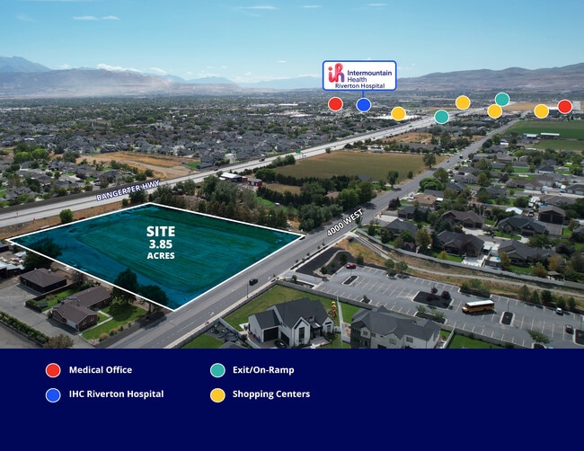
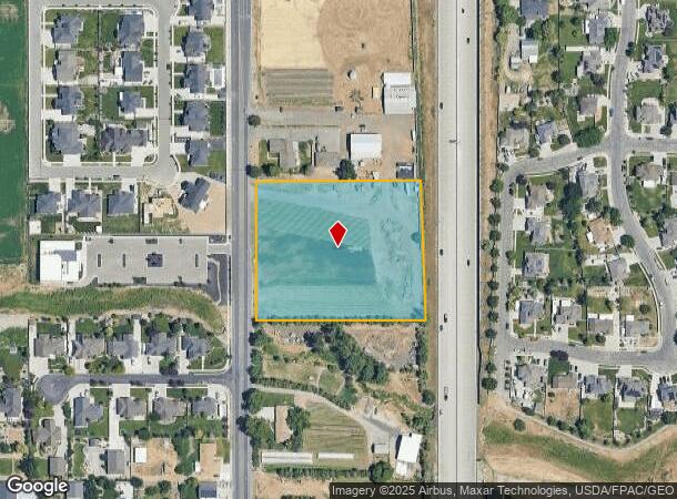
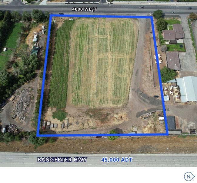
This Property Is For Sale
NEARBY LISTINGS FOR SALE OR LEASE
-
-
-
NWC Mountain View Corridor & 12600 South
Herriman, UT 84096
Rent Upon Request
0.93 - 6.80 AC Lot
Land
-
-
-
-
-
-
-
-
-
View all Riverton listings for sale on LoopNet.com
Property Detail
11985 S 4000 W
Salt Lake City, UT
Bangerter
27-29-101-008-0000
BEG S 0^0932 E 1066.470 FT & N 89^5028 E 33 FT FR NW CORSEC 29, T 3S, R 1W, SLM; N 0^0932 W 374.270 FT; N 89^5028 E 442.249 FT TO WLY RIGHT OF WAY OF BANGERTER HIGHWAY; S 2^0237 E 374.473 FT ALG SD WLY LINE; S 89^5028 W 454.565 FT TO BEG. 3.853 ACRES
Commercialacreage
Salt Lake
X
Utah
49035C0436G
3.85 AC
2024
Southwest Valley
2025
Salt Lake City
113112
DEMOGRAPHICS near 11985 S 4000 W
1 Mile
3 Mile
5 Mile
2024 Total Population
14,105
124,625
245,832
2029 Population
14,447
128,865
254,020
Pop Growth 2024-2029
+ 2.42%
+ 3.40%
+ 3.33%
Average Age
33
34
35
2024 Total Households
3,934
36,567
72,569
HH Growth 2024-2029
+ 2.57%
+ 3.67%
+ 3.55%
Median Household Inc
$123,569
$123,182
$119,195
Avg Household Size
3.60
3.40
3.30
2024 Avg HH Vehicles
3.00
2.00
2.00
Median Home Value
$701,962
$682,536
$673,606
Median Year Built
2006
2009
2006
Nearby Places
- Restaurants
- Banks
- Shops
- Fitness
- Groceries
PUBLIC TRANSPORTATION
COMMUTER RAIL
DRIVE
WALK
Distance
13 min
6.2 mi
DRIVE
WALK
Distance
13 min
6.4 mi
AIRPORT
Salt Lake City International
DRIVE
WALK
Distance
Salt Lake City International
27 min
17.8 mi
Provo Municipal
DRIVE
WALK
Distance
Provo Municipal
44 min
34.4 mi
Nearby Properties
Address
Land Use
TOTAL SIZE
Lot Size
Zoning
Address
Land Use
TOTAL SIZE
Lot Size
Zoning
540,554 SF
63.03 AC
C-R
Address
Land Use
TOTAL SIZE
Lot Size
Zoning
285,200 SF
55.78 AC
1210
Address
Land Use
TOTAL SIZE
Lot Size
Zoning
284,727 SF
26.33 AC
4144
Address
Land Use
TOTAL SIZE
Lot Size
Zoning
554,682 SF
30.25 AC
SLR-SP
Address
Land Use
TOTAL SIZE
Lot Size
Zoning
126,150 SF
25.43 AC
RM
Address
Land Use
TOTAL SIZE
Lot Size
Zoning
591,044 SF
13.87 AC
C-2
Address
Land Use
TOTAL SIZE
Lot Size
Zoning
469,074 SF
5.14 AC
C-P
Address
Land Use
TOTAL SIZE
Lot Size
Zoning
702,100 SF
13.83 AC
P-C
Address
Land Use
TOTAL SIZE
Lot Size
Zoning
73,318 SF
1.36 AC
PC
Address
Land Use
TOTAL SIZE
Lot Size
Zoning
269,342 SF
12.68 AC
MU-2
Address
Land Use
TOTAL SIZE
Lot Size
Zoning
323,922 SF
30.86 AC
PCC
Address
Land Use
TOTAL SIZE
Lot Size
Zoning
137,750 SF
12.64 AC
1210
Address
Land Use
TOTAL SIZE
Lot Size
Zoning
256,933 SF
19.68 AC
P-C
Address
Land Use
TOTAL SIZE
Lot Size
Zoning
59,711 SF
4.77 AC
C-2
Address
Land Use
TOTAL SIZE
Lot Size
Zoning
425,753 SF
2.28 AC
PC
Address
Land Use
TOTAL SIZE
Lot Size
Zoning
398,447 SF
11.04 AC
BMHU
Address
Land Use
TOTAL SIZE
Lot Size
Zoning
333,331 SF
10.13 AC
MU-2
Address
Land Use
TOTAL SIZE
Lot Size
Zoning
348,043 SF
5.35 AC
PC
Address
Land Use
TOTAL SIZE
Lot Size
Zoning
100,474 SF
12.99 AC
R-M-18
Address
Land Use
TOTAL SIZE
Lot Size
Zoning
348,917 SF
6.23 AC
PC
Address
Land Use
TOTAL SIZE
Lot Size
Zoning
456,759 SF
28.63 AC
C-R
Address
Land Use
TOTAL SIZE
Lot Size
Zoning
4.76 AC
PC
Address
Land Use
TOTAL SIZE
Lot Size
Zoning
232,874 SF
7.04 AC
RM-18
Address
Land Use
TOTAL SIZE
Lot Size
Zoning
227,345 SF
34.06 AC
M-1
Address
Land Use
TOTAL SIZE
Lot Size
Zoning
228,360 SF
41 AC
PCC
Address
Land Use
TOTAL SIZE
Lot Size
Zoning
272,200 SF
10.66 AC
SPRM18
Address
Land Use
TOTAL SIZE
Lot Size
Zoning
118.74 AC
4180
Address
Land Use
TOTAL SIZE
Lot Size
Zoning
292,006 SF
29.40 AC
1122
Address
Land Use
TOTAL SIZE
Lot Size
Zoning
Address
Land Use
TOTAL SIZE
Lot Size
Zoning
335,803 SF
8.63 AC
C-D
The World's #1 Commercial Real Estate Marketplace
Connect with us
© 2025 CoStar Group
The information above has been obtained from sources believed reliable. While we do not doubt its accuracy we have not verified it and make no guarantee, warranty or representation about it. It is your responsibility to independently confirm its accuracy and completeness. Any projections, opinions, assumptions, or estimates used are for example only and do not represent the current or future performance of the property. The value of this transaction to you depends on tax and other factors which should be evaluated by your tax, financial, and legal advisors. You and your advisors should conduct a careful, independent investigation of the property to determine to your satisfaction the suitability of the property for your needs.