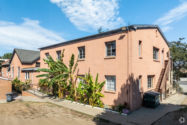
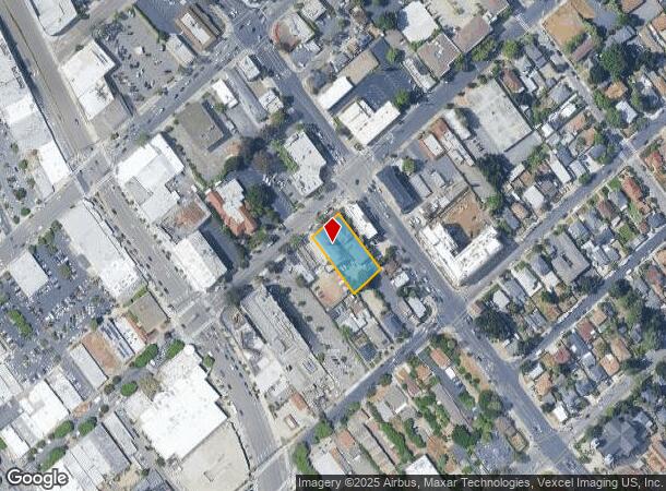
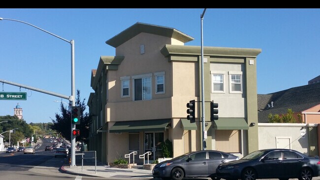
Property Record
1181 B St, Hayward, CA 94541
NEARBY LISTINGS FOR SALE OR LEASE
Property Detail
1181 B St
Religious
Alameda
X
California
06001C0287G
0.45 AC
2024
Hayward/Castro Valley
2025
East Bay/Oakland
435400
Oakland-Fremont-Berkeley, CA
12,916 SF
427-0011-024-01
DEMOGRAPHICS near 1181 B St
1 Mile
3 Mile
5 Mile
2024 Total Population
30,101
215,592
341,167
2029 Population
29,305
208,407
329,776
Pop Growth 2024-2029
(2.64%)
(3.33%)
(3.34%)
Average Age
40
39
40
2024 Total Households
10,924
69,227
110,039
HH Growth 2024-2029
(2.78%)
(3.51%)
(3.53%)
Median Household Inc
$91,581
$96,902
$97,887
Avg Household Size
2.60
3.00
3.00
2024 Avg HH Vehicles
2.00
2.00
2.00
Median Home Value
$713,369
$776,440
$774,307
Median Year Built
1969
1966
1967
Nearby Places
Map Layers
Map Styles
 Street
 Aerial
- Restaurants
- Banks
- Shops
- Fitness
- Groceries
PUBLIC TRANSPORTATION
COMMUTER RAIL
DRIVE
WALK
Distance
4 min
1.5 mi
DRIVE
WALK
Distance
4 min
1.5 mi
AIRPORT
Metro Oakland International
DRIVE
WALK
Distance
Metro Oakland International
16 min
10.5 mi
San Francisco International
DRIVE
WALK
Distance
San Francisco International
32 min
23.4 mi
Norman Y Mineta San Jose International
DRIVE
WALK
Distance
Norman Y Mineta San Jose International
36 min
27.9 mi
Freight Ports
Port of Oakland
DRIVE
WALK
Distance
Port of Oakland
20 min
15.0 mi
SALE & LEASE HISTORY
LISTING DATE
SALE/LEASE

Jun 12, 2018
For Lease
Dec 13, 2019
For Lease
Nearby Properties
Address
Land Use
TOTAL SIZE
Lot Size
Zoning
Address
Land Use
TOTAL SIZE
Lot Size
Zoning
710,091 SF
50.34 AC
Address
Land Use
TOTAL SIZE
Lot Size
Zoning
4.90 AC
Address
Land Use
TOTAL SIZE
Lot Size
Zoning
2.48 AC
Address
Land Use
TOTAL SIZE
Lot Size
Zoning
470,929 SF
31.62 AC
Address
Land Use
TOTAL SIZE
Lot Size
Zoning
1.50 AC
Address
Land Use
TOTAL SIZE
Lot Size
Zoning
150,856 SF
5.99 AC
Address
Land Use
TOTAL SIZE
Lot Size
Zoning
187,926 SF
1.19 AC
Address
Land Use
TOTAL SIZE
Lot Size
Zoning
160,987 SF
7.20 AC
Address
Land Use
TOTAL SIZE
Lot Size
Zoning
297,592 SF
11.65 AC
Address
Land Use
TOTAL SIZE
Lot Size
Zoning
310,072 SF
14.96 AC
Address
Land Use
TOTAL SIZE
Lot Size
Zoning
228,736 SF
5.95 AC
Address
Land Use
TOTAL SIZE
Lot Size
Zoning
169,371 SF
4.63 AC
Address
Land Use
TOTAL SIZE
Lot Size
Zoning
116,485 SF
1.81 AC
Address
Land Use
TOTAL SIZE
Lot Size
Zoning
137,889 SF
18.44 AC
Address
Land Use
TOTAL SIZE
Lot Size
Zoning
116,750 SF
4.72 AC
Address
Land Use
TOTAL SIZE
Lot Size
Zoning
105,730 SF
5.32 AC
Address
Land Use
TOTAL SIZE
Lot Size
Zoning
140,850 SF
9.98 AC
Address
Land Use
TOTAL SIZE
Lot Size
Zoning
89,968 SF
5 AC
Address
Land Use
TOTAL SIZE
Lot Size
Zoning
329,346 SF
29.36 AC
Address
Land Use
TOTAL SIZE
Lot Size
Zoning
119,800 SF
5.72 AC
Address
Land Use
TOTAL SIZE
Lot Size
Zoning
57,497 SF
4.92 AC
Address
Land Use
TOTAL SIZE
Lot Size
Zoning
84,690 SF
6.25 AC
CN
Address
Land Use
TOTAL SIZE
Lot Size
Zoning
120,441 SF
1.34 AC
Address
Land Use
TOTAL SIZE
Lot Size
Zoning
152,950 SF
4.96 AC
Address
Land Use
TOTAL SIZE
Lot Size
Zoning
115,648 SF
11.19 AC
Address
Land Use
TOTAL SIZE
Lot Size
Zoning
92,534 SF
3.04 AC
Address
Land Use
TOTAL SIZE
Lot Size
Zoning
137,422 SF
5.56 AC
RH
Address
Land Use
TOTAL SIZE
Lot Size
Zoning
118,083 SF
4.70 AC
Address
Land Use
TOTAL SIZE
Lot Size
Zoning
94,485 SF
8.31 AC
Address
Land Use
TOTAL SIZE
Lot Size
Zoning
The World's #1 Commercial Real Estate Marketplace
Connect with us
© 2026 CoStar Group
The information above has been obtained from sources believed reliable. While we do not doubt its accuracy we have not verified it and make no guarantee, warranty or representation about it. It is your responsibility to independently confirm its accuracy and completeness. Any projections, opinions, assumptions, or estimates used are for example only and do not represent the current or future performance of the property. The value of this transaction to you depends on tax and other factors which should be evaluated by your tax, financial, and legal advisors. You and your advisors should conduct a careful, independent investigation of the property to determine to your satisfaction the suitability of the property for your needs.