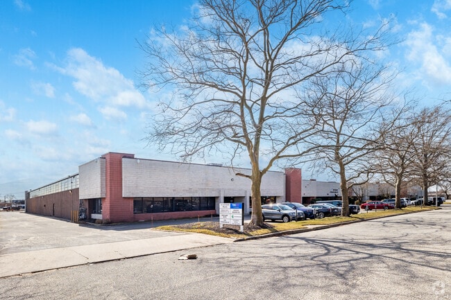
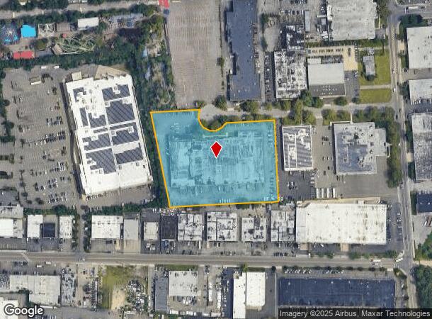
Property Record
10 Dubon Ct, Farmingdale, NY 11735

Current Lease Availabilities
NEARBY LISTINGS FOR SALE OR LEASE
Property Detail
10 Dubon Ct
0100-003-00-01-00-004-009
N-DUBON CT E-NEW HWY S-VARIOUS W-MARCUS
Industrialgeneral
Suffolk
X
New York
36103C0620H
4
2024
3.93 AC
2024
East Farmingdale
122300
Long Island (New York)
78,100 SF
Nassau County-Suffolk County, NY
DEMOGRAPHICS near 10 Dubon Ct
1 Mile
3 Mile
5 Mile
2024 Total Population
3,245
63,070
301,699
2029 Population
3,198
61,809
295,656
Pop Growth 2024-2029
(1.45%)
(2.00%)
(2.00%)
Average Age
46
42
42
2024 Total Households
1,203
20,873
98,007
HH Growth 2024-2029
(2.33%)
(2.15%)
(2.14%)
Median Household Inc
$115,151
$123,624
$122,842
Avg Household Size
2.30
2.90
2.90
2024 Avg HH Vehicles
2.00
2.00
2.00
Median Home Value
$625,553
$559,059
$561,747
Median Year Built
1999
1964
1959
Nearby Places
Map Layers
Map Styles
 Street
 Aerial
- Restaurants
- Banks
- Shops
- Fitness
- Groceries
PUBLIC TRANSPORTATION
COMMUTER RAIL
Pinelawn Station (Ronkonkoma Branch - Long Island Rail Road)
DRIVE
WALK
Distance
Pinelawn Station (Ronkonkoma Branch - Long Island Rail Road)
5 min
1.7 mi
Farmingdale Station (Ronkonkoma Branch - Long Island Rail Road)
DRIVE
WALK
Distance
Farmingdale Station (Ronkonkoma Branch - Long Island Rail Road)
6 min
2.6 mi
AIRPORT
Long Island MacArthur
DRIVE
WALK
Distance
Long Island MacArthur
33 min
20.7 mi
John F Kennedy International
DRIVE
WALK
Distance
John F Kennedy International
39 min
26.9 mi
LaGuardia
DRIVE
WALK
Distance
LaGuardia
47 min
30.2 mi
Freight Ports
NY - Red Hook Container Terminal
DRIVE
WALK
Distance
NY - Red Hook Container Terminal
58 min
38.3 mi
Nearby Properties
Address
Land Use
TOTAL SIZE
Lot Size
Zoning
Address
Land Use
TOTAL SIZE
Lot Size
Zoning
37 AC
I2
Address
Land Use
TOTAL SIZE
Lot Size
Zoning
3.31 AC
R40
Address
Land Use
TOTAL SIZE
Lot Size
Zoning
116,514 SF
382 AC
Address
Land Use
TOTAL SIZE
Lot Size
Zoning
35,978 SF
375.68 AC
Address
Land Use
TOTAL SIZE
Lot Size
Zoning
16,520 SF
160.33 AC
Address
Land Use
TOTAL SIZE
Lot Size
Zoning
1,945 SF
278.09 AC
Address
Land Use
TOTAL SIZE
Lot Size
Zoning
33.80 AC
Address
Land Use
TOTAL SIZE
Lot Size
Zoning
77,270 SF
21.67 AC
Address
Land Use
TOTAL SIZE
Lot Size
Zoning
336,442 SF
43.50 AC
G
Address
Land Use
TOTAL SIZE
Lot Size
Zoning
288 SF
194.85 AC
Address
Land Use
TOTAL SIZE
Lot Size
Zoning
3,951 SF
44.33 AC
Address
Land Use
TOTAL SIZE
Lot Size
Zoning
52.10 AC
Address
Land Use
TOTAL SIZE
Lot Size
Zoning
52,750 SF
55.67 AC
Address
Land Use
TOTAL SIZE
Lot Size
Zoning
37.20 AC
I2
Address
Land Use
TOTAL SIZE
Lot Size
Zoning
24.75 AC
R40
Address
Land Use
TOTAL SIZE
Lot Size
Zoning
183.15 AC
Address
Land Use
TOTAL SIZE
Lot Size
Zoning
11.50 AC
C10
Address
Land Use
TOTAL SIZE
Lot Size
Zoning
2.92 AC
R20
Address
Land Use
TOTAL SIZE
Lot Size
Zoning
12 AC
I1
Address
Land Use
TOTAL SIZE
Lot Size
Zoning
22.20 AC
I1
Address
Land Use
TOTAL SIZE
Lot Size
Zoning
14.40 AC
I1
Address
Land Use
TOTAL SIZE
Lot Size
Zoning
74.90 AC
G
Address
Land Use
TOTAL SIZE
Lot Size
Zoning
157,191 SF
17.70 AC
G
Address
Land Use
TOTAL SIZE
Lot Size
Zoning
114.70 AC
A
Address
Land Use
TOTAL SIZE
Lot Size
Zoning
292.40 AC
A
Address
Land Use
TOTAL SIZE
Lot Size
Zoning
0.26 AC
R20
Address
Land Use
TOTAL SIZE
Lot Size
Zoning
32.60 AC
I1
Address
Land Use
TOTAL SIZE
Lot Size
Zoning
248.60 AC
A
Address
Land Use
TOTAL SIZE
Lot Size
Zoning
16 AC
I1
Address
Land Use
TOTAL SIZE
Lot Size
Zoning
23.66 AC
I1
The World's #1 Commercial Real Estate Marketplace
Connect with us
© 2025 CoStar Group
The information above has been obtained from sources believed reliable. While we do not doubt its accuracy we have not verified it and make no guarantee, warranty or representation about it. It is your responsibility to independently confirm its accuracy and completeness. Any projections, opinions, assumptions, or estimates used are for example only and do not represent the current or future performance of the property. The value of this transaction to you depends on tax and other factors which should be evaluated by your tax, financial, and legal advisors. You and your advisors should conduct a careful, independent investigation of the property to determine to your satisfaction the suitability of the property for your needs.