Property Record
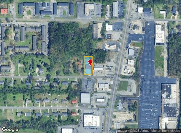
12 24Th Ave Nw, Center Point, AL 35215
NEARBY LISTINGS FOR SALE OR LEASE
Property Detail
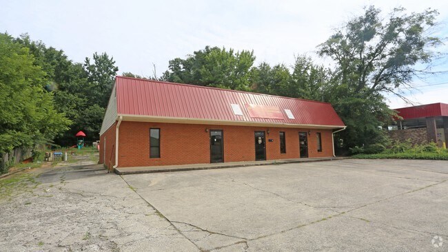
12 24Th Ave Nw
12-00-07-3-013-003.002
COM AT SE COR OF SE 1/4 OF SW 1/4 SEC 7 TP 16 R1W TH WLY 504.7 FT TH N 25.3 FT TO POB TH W 95 FT TH N 200 FT TH E 95 FT TH S 200 FT TO POB
Officebuilding
Jefferson
X
Alabama
01073C0243J
0.44 AC
2024
Center Point
2024
Birmingham
011209
Birmingham-Hoover, AL
3,268 SF
DEMOGRAPHICS near 12 24Th Ave Nw
1 Mile
3 Mile
5 Mile
2024 Total Population
9,743
53,958
86,700
2029 Population
9,607
52,935
84,792
Pop Growth 2024-2029
(1.40%)
(1.90%)
(2.20%)
Average Age
35
37
38
2024 Total Households
3,626
20,211
32,920
HH Growth 2024-2029
(1.41%)
(1.93%)
(2.25%)
Median Household Inc
$41,469
$47,707
$53,044
Avg Household Size
2.60
2.60
2.60
2024 Avg HH Vehicles
2.00
2.00
2.00
Median Home Value
$133,364
$145,911
$157,029
Median Year Built
1972
1976
1977
Nearby Places
Map Layers
Map Styles
 Street
 Aerial
- Restaurants
- Banks
- Shops
- Fitness
- Groceries
PUBLIC TRANSPORTATION
AIRPORT
Birmingham-Shuttlesworth International
DRIVE
WALK
Distance
Birmingham-Shuttlesworth International
17 min
9.9 mi
Freight Ports
Port of Mobile
DRIVE
WALK
Distance
Port of Mobile
299 min
270.8 mi
SALE & LEASE HISTORY
LISTING DATE
SALE/LEASE

Oct 22, 2019
For Sale
Aug 15, 2018
For Sale
Nearby Properties
Address
Land Use
TOTAL SIZE
Lot Size
Zoning
Address
Land Use
TOTAL SIZE
Lot Size
Zoning
150,160 SF
12 AC
INST
Address
Land Use
TOTAL SIZE
Lot Size
Zoning
1 SF
7.08 AC
CB2
Address
Land Use
TOTAL SIZE
Lot Size
Zoning
207,383 SF
17 AC
CR5
Address
Land Use
TOTAL SIZE
Lot Size
Zoning
623,200 SF
50 AC
CM2
Address
Land Use
TOTAL SIZE
Lot Size
Zoning
218,922 SF
21 AC
CR5
Address
Land Use
TOTAL SIZE
Lot Size
Zoning
192,596 SF
13.79 AC
CR5
Address
Land Use
TOTAL SIZE
Lot Size
Zoning
147,200 SF
7.93 AC
CR5
Address
Land Use
TOTAL SIZE
Lot Size
Zoning
531,808 SF
23.96 AC
I4&A
Address
Land Use
TOTAL SIZE
Lot Size
Zoning
502,302 SF
24.61 AC
I4&A
Address
Land Use
TOTAL SIZE
Lot Size
Zoning
95,172 SF
6.40 AC
R2
Address
Land Use
TOTAL SIZE
Lot Size
Zoning
125,252 SF
8.07 AC
R4
Address
Land Use
TOTAL SIZE
Lot Size
Zoning
116,732 SF
4.06 AC
R-4
Address
Land Use
TOTAL SIZE
Lot Size
Zoning
179,464 SF
17.70 AC
M3
Address
Land Use
TOTAL SIZE
Lot Size
Zoning
86,434 SF
8.20 AC
QM1
Address
Land Use
TOTAL SIZE
Lot Size
Zoning
80,834 SF
7.13 AC
CR5
Address
Land Use
TOTAL SIZE
Lot Size
Zoning
43,451 SF
5.22 AC
INST
Address
Land Use
TOTAL SIZE
Lot Size
Zoning
26,169 SF
71 AC
R2
Address
Land Use
TOTAL SIZE
Lot Size
Zoning
109,878 SF
10 AC
C1
Address
Land Use
TOTAL SIZE
Lot Size
Zoning
115,544 SF
12 AC
CB2
Address
Land Use
TOTAL SIZE
Lot Size
Zoning
74,159 SF
2.50 AC
INST
Address
Land Use
TOTAL SIZE
Lot Size
Zoning
43,298 SF
5.59 AC
INST
Address
Land Use
TOTAL SIZE
Lot Size
Zoning
56,360 SF
2.80 AC
INST
Address
Land Use
TOTAL SIZE
Lot Size
Zoning
257,988 SF
CM2
Address
Land Use
TOTAL SIZE
Lot Size
Zoning
69,066 SF
7.30 AC
C1
Address
Land Use
TOTAL SIZE
Lot Size
Zoning
63,736 SF
11 AC
I
Address
Land Use
TOTAL SIZE
Lot Size
Zoning
84,602 SF
11.20 AC
B2
Address
Land Use
TOTAL SIZE
Lot Size
Zoning
118,041 SF
5.10 AC
C1
Address
Land Use
TOTAL SIZE
Lot Size
Zoning
113,175 SF
21.85 AC
I2
Address
Land Use
TOTAL SIZE
Lot Size
Zoning
44,912 SF
14.50 AC
I4-U
Address
Land Use
TOTAL SIZE
Lot Size
Zoning
61,472 SF
18.84 AC
INT-
The World's #1 Commercial Real Estate Marketplace
Connect with us
© 2025 CoStar Group
The information above has been obtained from sources believed reliable. While we do not doubt its accuracy we have not verified it and make no guarantee, warranty or representation about it. It is your responsibility to independently confirm its accuracy and completeness. Any projections, opinions, assumptions, or estimates used are for example only and do not represent the current or future performance of the property. The value of this transaction to you depends on tax and other factors which should be evaluated by your tax, financial, and legal advisors. You and your advisors should conduct a careful, independent investigation of the property to determine to your satisfaction the suitability of the property for your needs.