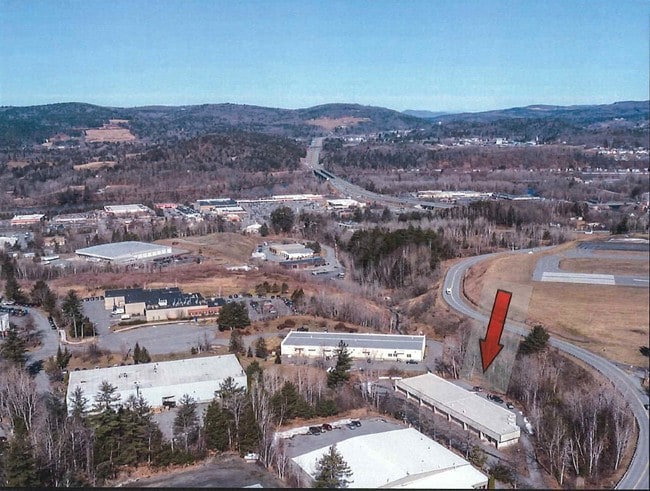
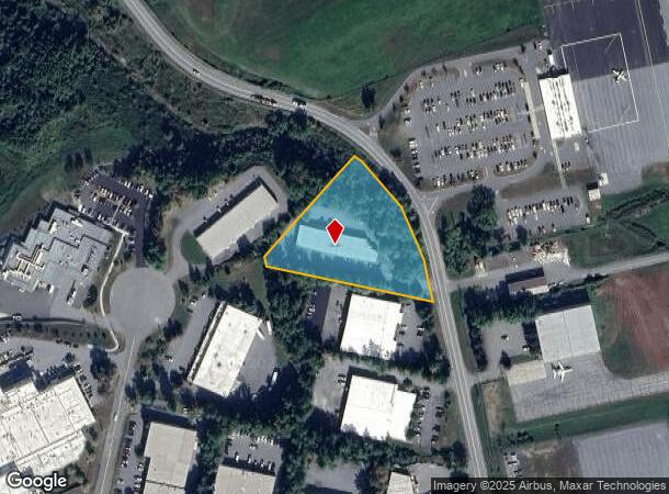
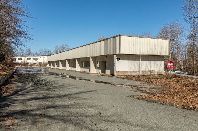
Property Record
12 Airpark Rd, West Lebanon, NH 03784
NEARBY LISTINGS FOR SALE OR LEASE
Property Detail
12 Airpark Rd
Warehouse
Grafton
X
New Hampshire
33009C1060E
2.20 AC
2024
Other Market Areas
2024
Claremont-Lebanon, NH-VT
961801
LBAN-000130-000006
9,930 SF
DEMOGRAPHICS near 12 Airpark Rd
1 Mile
3 Mile
5 Mile
2024 Total Population
46
9,492
23,192
2029 Population
48
9,791
24,039
Pop Growth 2024-2029
+ 4.35%
+ 3.15%
+ 3.65%
Average Age
47
43
43
2024 Total Households
22
4,423
11,010
HH Growth 2024-2029
+ 4.55%
+ 2.96%
+ 3.58%
Median Household Inc
$79,167
$74,156
$82,164
Avg Household Size
2.10
2.10
2.00
2024 Avg HH Vehicles
2.00
2.00
2.00
Median Home Value
$374,999
$277,105
$281,602
Median Year Built
1991
1973
1980
Nearby Places
Map Layers
Map Styles
 Street
 Aerial
- Restaurants
- Banks
- Shops
- Fitness
- Groceries
PUBLIC TRANSPORTATION
COMMUTER RAIL
White River Junction Amtrak Station (Vermonter - Amtrak)
DRIVE
WALK
Distance
White River Junction Amtrak Station (Vermonter - Amtrak)
10 min
3.2 mi
Freight Ports
Albany, NY Port
DRIVE
WALK
Distance
Albany, NY Port
196 min
131.9 mi
SALE & LEASE HISTORY
LISTING DATE
SALE/LEASE

Oct 03, 2018
For Lease
Jan 31, 2019
For Sale
Nearby Properties
Address
Land Use
TOTAL SIZE
Lot Size
Zoning
Address
Land Use
TOTAL SIZE
Lot Size
Zoning
447.50 AC
INDL
Address
Land Use
TOTAL SIZE
Lot Size
Zoning
29.80 AC
GC
Address
Land Use
TOTAL SIZE
Lot Size
Zoning
3.76 AC
GC
Address
Land Use
TOTAL SIZE
Lot Size
Zoning
1,315 SF
16.35 AC
RL3
Address
Land Use
TOTAL SIZE
Lot Size
Zoning
14.11 AC
INDL
Address
Land Use
TOTAL SIZE
Lot Size
Zoning
18.38 AC
R3
Address
Land Use
TOTAL SIZE
Lot Size
Zoning
22.14 AC
GC
Address
Land Use
TOTAL SIZE
Lot Size
Zoning
10.20 AC
R3
Address
Land Use
TOTAL SIZE
Lot Size
Zoning
Address
Land Use
TOTAL SIZE
Lot Size
Zoning
23.33 AC
R3
Address
Land Use
TOTAL SIZE
Lot Size
Zoning
22.88 AC
GC
Address
Land Use
TOTAL SIZE
Lot Size
Zoning
36.71 AC
GC
Address
Land Use
TOTAL SIZE
Lot Size
Zoning
20.61 AC
GC
Address
Land Use
TOTAL SIZE
Lot Size
Zoning
80,493 SF
7.39 AC
GC
Address
Land Use
TOTAL SIZE
Lot Size
Zoning
7.89 AC
GC
Address
Land Use
TOTAL SIZE
Lot Size
Zoning
Address
Land Use
TOTAL SIZE
Lot Size
Zoning
26.70 AC
INDL
Address
Land Use
TOTAL SIZE
Lot Size
Zoning
7.63 AC
GC
Address
Land Use
TOTAL SIZE
Lot Size
Zoning
54.48 AC
R3
Address
Land Use
TOTAL SIZE
Lot Size
Zoning
11.23 AC
GC
Address
Land Use
TOTAL SIZE
Lot Size
Zoning
15.60 AC
GC
Address
Land Use
TOTAL SIZE
Lot Size
Zoning
44,695 SF
35.80 AC
HC
Address
Land Use
TOTAL SIZE
Lot Size
Zoning
163,990 SF
10.19 AC
INDL
Address
Land Use
TOTAL SIZE
Lot Size
Zoning
323.53 AC
INDH
Address
Land Use
TOTAL SIZE
Lot Size
Zoning
99.80 AC
INDH
Address
Land Use
TOTAL SIZE
Lot Size
Zoning
0.87 AC
CB
Address
Land Use
TOTAL SIZE
Lot Size
Zoning
7.28 AC
GC
Address
Land Use
TOTAL SIZE
Lot Size
Zoning
102,489 SF
GC
Address
Land Use
TOTAL SIZE
Lot Size
Zoning
4.54 AC
GC
Address
Land Use
TOTAL SIZE
Lot Size
Zoning
7.88 AC
R2
The World's #1 Commercial Real Estate Marketplace
Connect with us
© 2025 CoStar Group
The information above has been obtained from sources believed reliable. While we do not doubt its accuracy we have not verified it and make no guarantee, warranty or representation about it. It is your responsibility to independently confirm its accuracy and completeness. Any projections, opinions, assumptions, or estimates used are for example only and do not represent the current or future performance of the property. The value of this transaction to you depends on tax and other factors which should be evaluated by your tax, financial, and legal advisors. You and your advisors should conduct a careful, independent investigation of the property to determine to your satisfaction the suitability of the property for your needs.