Property Record
12 Banton St, Dorchester Center, MA 02124

NEARBY LISTINGS FOR SALE OR LEASE
Property Detail
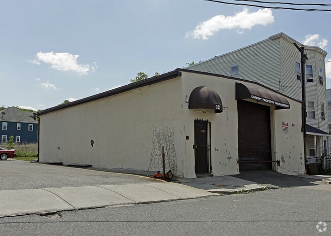
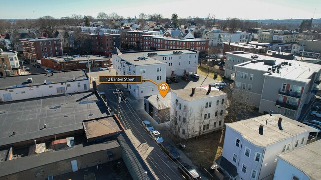
12 Banton St
Commercialbuilding
Suffolk
X
Massachusetts
25025C0087G
0.04 AC
2025
Roxbury/Dorchester
2025
Boston
100500
Boston-Cambridge-Newton, MA-NH
1,560 SF
DORC-000000-000016-001499
DEMOGRAPHICS near 12 Banton St
1 Mile
3 Mile
5 Mile
2024 Total Population
47,547
265,341
635,563
2029 Population
44,269
252,858
611,333
Pop Growth 2024-2029
(6.89%)
(4.70%)
(3.81%)
Average Age
39
39
38
2024 Total Households
16,996
99,256
258,076
HH Growth 2024-2029
(7.58%)
(5.17%)
(4.08%)
Median Household Inc
$77,257
$71,196
$86,175
Avg Household Size
2.60
2.50
2.20
2024 Avg HH Vehicles
1.00
1.00
1.00
Median Home Value
$636,389
$651,056
$737,019
Median Year Built
1946
1948
1949
Nearby Places
Map Layers
Map Styles
 Street
 Aerial
- Restaurants
- Banks
- Shops
- Fitness
- Groceries
PUBLIC TRANSPORTATION
TRANSIT/SUBWAY
Ashmont Station (Ashmont Mattapan High Speed Line - Massachusetts Bay Transportation Authority Subway (The T), Red Line - Massachusetts Bay Transportation Authority Subway (The T))
DRIVE
WALK
Distance
Ashmont Station (Ashmont Mattapan High Speed Line - Massachusetts Bay Transportation Authority Subway (The T), Red Line - Massachusetts Bay Transportation Authority Subway (The T))
2 min
7 min
0.4 mi
Shawmut Station (Red Line - Massachusetts Bay Transportation Authority Subway (The T))
DRIVE
WALK
Distance
Shawmut Station (Red Line - Massachusetts Bay Transportation Authority Subway (The T))
1 min
9 min
0.5 mi
Cedar Grove Station (Ashmont Mattapan High Speed Line - Massachusetts Bay Transportation Authority Subway (The T))
DRIVE
WALK
Distance
Cedar Grove Station (Ashmont Mattapan High Speed Line - Massachusetts Bay Transportation Authority Subway (The T))
2 min
15 min
0.8 mi
Fields Corner Station (Red Line - Massachusetts Bay Transportation Authority Subway (The T))
DRIVE
WALK
Distance
Fields Corner Station (Red Line - Massachusetts Bay Transportation Authority Subway (The T))
2 min
18 min
0.9 mi
COMMUTER RAIL
Talbot Avenue (Fairmount Line - MBTA, Franklin/Foxboro Line - MBTA)
DRIVE
WALK
Distance
Talbot Avenue (Fairmount Line - MBTA, Franklin/Foxboro Line - MBTA)
2 min
19 min
1.0 mi
Morton Street (Fairmount Line - Massachusetts Bay Transportation Authority Commuter Rail (Purple Line))
DRIVE
WALK
Distance
Morton Street (Fairmount Line - Massachusetts Bay Transportation Authority Commuter Rail (Purple Line))
3 min
1.7 mi
AIRPORT
General Edward Lawrence Logan International
DRIVE
WALK
Distance
General Edward Lawrence Logan International
17 min
8.0 mi
Freight Ports
Port of Boston
DRIVE
WALK
Distance
Port of Boston
14 min
5.7 mi
SALE & LEASE HISTORY
LISTING DATE
SALE/LEASE

May 07, 2018
For Sale
Feb 26, 2024
For Sale
Nearby Properties
Address
Land Use
TOTAL SIZE
Lot Size
Zoning
Address
Land Use
TOTAL SIZE
Lot Size
Zoning
262,120 SF
0.62 AC
C
Address
Land Use
TOTAL SIZE
Lot Size
Zoning
259,990 SF
2.84 AC
E
Address
Land Use
TOTAL SIZE
Lot Size
Zoning
303,055 SF
2.15 AC
RC
Address
Land Use
TOTAL SIZE
Lot Size
Zoning
251,272 SF
3.77 AC
BUSC
Address
Land Use
TOTAL SIZE
Lot Size
Zoning
254,856 SF
4.05 AC
BUSC
Address
Land Use
TOTAL SIZE
Lot Size
Zoning
255,257 SF
2.34 AC
A
Address
Land Use
TOTAL SIZE
Lot Size
Zoning
1,940 SF
58.17 AC
E
Address
Land Use
TOTAL SIZE
Lot Size
Zoning
681,518 SF
34.52 AC
Address
Land Use
TOTAL SIZE
Lot Size
Zoning
240.18 AC
E
Address
Land Use
TOTAL SIZE
Lot Size
Zoning
291,918 SF
1.99 AC
RC
Address
Land Use
TOTAL SIZE
Lot Size
Zoning
332,366 SF
4.86 AC
E
Address
Land Use
TOTAL SIZE
Lot Size
Zoning
728,348 SF
11.71 AC
C
Address
Land Use
TOTAL SIZE
Lot Size
Zoning
228,215 SF
2.44 AC
RC
Address
Land Use
TOTAL SIZE
Lot Size
Zoning
526,040 SF
27.79 AC
E
Address
Land Use
TOTAL SIZE
Lot Size
Zoning
383,811 SF
5.86 AC
RESB
Address
Land Use
TOTAL SIZE
Lot Size
Zoning
132,321 SF
3.94 AC
RC
Address
Land Use
TOTAL SIZE
Lot Size
Zoning
88.20 AC
E
Address
Land Use
TOTAL SIZE
Lot Size
Zoning
53.23 AC
E
Address
Land Use
TOTAL SIZE
Lot Size
Zoning
377,249 SF
2.81 AC
RC
Address
Land Use
TOTAL SIZE
Lot Size
Zoning
173,630 SF
4.46 AC
E
Address
Land Use
TOTAL SIZE
Lot Size
Zoning
17.85 AC
BUSC
Address
Land Use
TOTAL SIZE
Lot Size
Zoning
150,987 SF
6.90 AC
PUD
Address
Land Use
TOTAL SIZE
Lot Size
Zoning
201,924 SF
2.17 AC
RC
Address
Land Use
TOTAL SIZE
Lot Size
Zoning
560,065 SF
28.20 AC
Address
Land Use
TOTAL SIZE
Lot Size
Zoning
217,302 SF
13.47 AC
RA
Address
Land Use
TOTAL SIZE
Lot Size
Zoning
221,500 SF
4.99 AC
E
Address
Land Use
TOTAL SIZE
Lot Size
Zoning
275,752 SF
39.06 AC
E
Address
Land Use
TOTAL SIZE
Lot Size
Zoning
167,236 SF
13.61 AC
C
Address
Land Use
TOTAL SIZE
Lot Size
Zoning
247,316 SF
2.75 AC
E
Address
Land Use
TOTAL SIZE
Lot Size
Zoning
24,156 SF
7.65 AC
RESB
The World's #1 Commercial Real Estate Marketplace
Connect with us
© 2025 CoStar Group
The information above has been obtained from sources believed reliable. While we do not doubt its accuracy we have not verified it and make no guarantee, warranty or representation about it. It is your responsibility to independently confirm its accuracy and completeness. Any projections, opinions, assumptions, or estimates used are for example only and do not represent the current or future performance of the property. The value of this transaction to you depends on tax and other factors which should be evaluated by your tax, financial, and legal advisors. You and your advisors should conduct a careful, independent investigation of the property to determine to your satisfaction the suitability of the property for your needs.