Property Record
12 Belchertown Rd, Amherst, MA 01002
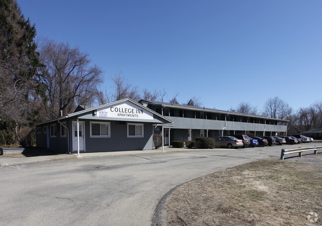
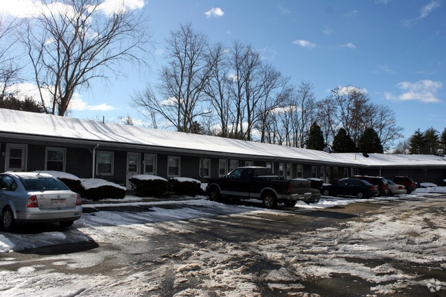

Property Detail
12 Belchertown Rd
AMHE-000015C-000002-000019
HAMPSHIRE
Apartment
Massachusetts
B and X Area of moderate flood hazard, usually the area between the limits of the 100-year and 500-year floods.
19
2025
0.91 AC
2025
Amherst/East Hampshire County
820500
Hartford
4,588 SF
Amherst Town-Northampton, MA
NEARBY LISTINGS FOR SALE OR LEASE
-
-
View all Amherst listings for sale on LoopNet.com
DEMOGRAPHICS near 12 Belchertown Rd
1 mile
3 mile
5 mile
2025 Total Population
5,813
40,778
50,720
2030 Population
5,904
40,989
50,888
Pop Growth 2025-2030
+ 1.57%
+ 0.52%
+ 0.33%
Average Age
32
31
33
2025 Total Households
1,923
9,539
13,634
HH Growth 2025-2030
+ 1.92%
+ 0.69%
+ 0.37%
Median Household Inc
$36,769
$63,472
$73,858
Avg Household Size
2.20
2.30
2.30
2025 Avg HH Vehicles
2.00
2.00
2.00
Median Home Value
$473,484
$468,368
$468,930
Median Year Built
1973
1974
1974
Nearby Places
Map Layers
Map Styles
 Street
 Aerial
Layers
 Traffic
 Biking
Places
Listings with unknown addresses are not visible on the map
- Restaurants
- Banks
- Shops
- Fitness
- Groceries
Nearby Properties
Address
Land Use
TOTAL SIZE
Lot Size
Zoning
Address
Land Use
TOTAL SIZE
Lot Size
Zoning
1,344 SF
284.31 AC
Address
Land Use
TOTAL SIZE
Lot Size
Zoning
168,500 SF
18.25 AC
C+I
Address
Land Use
TOTAL SIZE
Lot Size
Zoning
108,000 SF
14.34 AC
Address
Land Use
TOTAL SIZE
Lot Size
Zoning
23,690 SF
13.98 AC
Address
Land Use
TOTAL SIZE
Lot Size
Zoning
99,483 SF
1.04 AC
Address
Land Use
TOTAL SIZE
Lot Size
Zoning
10,248 SF
26.17 AC
Address
Land Use
TOTAL SIZE
Lot Size
Zoning
5,182 SF
20.70 AC
Address
Land Use
TOTAL SIZE
Lot Size
Zoning
13,426 SF
16 AC
Address
Land Use
TOTAL SIZE
Lot Size
Zoning
31.73 AC
Address
Land Use
TOTAL SIZE
Lot Size
Zoning
54,108 SF
16.47 AC
Address
Land Use
TOTAL SIZE
Lot Size
Zoning
74,959 SF
Address
Land Use
TOTAL SIZE
Lot Size
Zoning
10,080 SF
0.61 AC
Address
Land Use
TOTAL SIZE
Lot Size
Zoning
10,584 SF
7.17 AC
Address
Land Use
TOTAL SIZE
Lot Size
Zoning
16,492 SF
1.32 AC
Address
Land Use
TOTAL SIZE
Lot Size
Zoning
6,768 SF
6.53 AC
Address
Land Use
TOTAL SIZE
Lot Size
Zoning
3,692 SF
2.51 AC
Address
Land Use
TOTAL SIZE
Lot Size
Zoning
4,391 SF
12.40 AC
Address
Land Use
TOTAL SIZE
Lot Size
Zoning
13,664 SF
5 AC
Address
Land Use
TOTAL SIZE
Lot Size
Zoning
11,653 SF
5.54 AC
Address
Land Use
TOTAL SIZE
Lot Size
Zoning
1,156 SF
27.59 AC
Address
Land Use
TOTAL SIZE
Lot Size
Zoning
18,569 SF
Address
Land Use
TOTAL SIZE
Lot Size
Zoning
12,584 SF
3.85 AC
Address
Land Use
TOTAL SIZE
Lot Size
Zoning
7,672 SF
2.83 AC
Address
Land Use
TOTAL SIZE
Lot Size
Zoning
5,046 SF
2.50 AC
Address
Land Use
TOTAL SIZE
Lot Size
Zoning
14,256 SF
0.73 AC
Address
Land Use
TOTAL SIZE
Lot Size
Zoning
6,536 SF
3.33 AC
Address
Land Use
TOTAL SIZE
Lot Size
Zoning
7,312 SF
0.46 AC
Address
Land Use
TOTAL SIZE
Lot Size
Zoning
12,550 SF
1.06 AC
Address
Land Use
TOTAL SIZE
Lot Size
Zoning
6,472 SF
1.02 AC
Address
Land Use
TOTAL SIZE
Lot Size
Zoning
1,915 SF
6.15 AC
The World's #1 Commercial Real Estate Marketplace
Connect with us
© 2026 CoStar Group
The information above has been obtained from sources believed reliable. While we do not doubt its accuracy we have not verified it and make no guarantee, warranty or representation about it. It is your responsibility to independently confirm its accuracy and completeness. Any projections, opinions, assumptions, or estimates used are for example only and do not represent the current or future performance of the property. The value of this transaction to you depends on tax and other factors which should be evaluated by your tax, financial, and legal advisors. You and your advisors should conduct a careful, independent investigation of the property to determine to your satisfaction the suitability of the property for your needs.